![]()
United
Nations
Flood
, processed by ESA, CC BY-SA 3.0 IGO.")
Definition
Facts and figures
Further information
UN-SPIDER Regional Support Offices with hazard-specific expertise
Related content on the Knowledge Portal
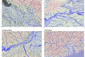 MERIT Hydro is a global hydrography datasets, developed based on the MERIT DEM and multiple inland water maps. It contains flow direction, flow accumulation, hydrologically adjusted elevations, and river channel width., High-resolution raster hydrography maps are a fundamental data source for many geoscience applications. Here we introduce MERIT Hydro, a new global flow direction map at 3 arc-second resolution (~90 m at the equator) derived from the latest elevation data (MERIT DEM) and water body datasets (G1WBM, GSWO, and OpenStreetMap). We developed a new algorithm to extract river networks near-automatically by separating actual inland basins from dummy depressions caused by the errors in input elevation data. After a minimum amount of hand-editing, the constructed hydrography map shows good agreement with existing quality-controlled river network datasets in terms of flow accumulation area and river basin shape. The location of river streamlines was realistically aligned with existing satellite-based global river channel data. Relative error in the drainage area was smaller than 0.05 for 90% of GRDC gauges, confirming the accuracy of the delineated global river networks. Discrepancies in flow…Publishing institution:
To support the National Office of Civil Protection (ONPC) of Tunisia and other government agencies in using space-based information for disaster management, UN-SPIDER conducted a three-day training in Tunis from 9 to 11 March. The course highlighted the relevance and usefulness of remote sensing and satellite data as a decision-making tool in risk and disaster management. It focused on the UN-SPIDER Recommended Practice for flood mapping with Sentinel-1 radar data to support authorities in responding to recurring floods in the country.
Twelve participants attended the event, which introduced them to remote sensing and provided an overview of synthetic-aperture radar (SAR) principles, before walking them step-by-step through downloading, processing and mapping data from the Sentinel-1 satellite using the free and open source software solutions SNAP and QGIS. The training also…
read more10/03/2020
Scientists from 50 scientific institutions, led by the National Aeronautics and Space Administration (NASA) and the European Space Agency (ESA) combined 26 independent satellite datasets to show that the Greenland Ice Sheet melt is increasing. The group studied data from 1992 to 2018, taking direct measurements of the continent-sized glacier. The study found that decade averages for ice melt has increased sevenfold from the 1990s.
The report shows that 1992 to 2002 averaged 1mm/decade in melt, 2008 to 2018 increased to a 7mm/decade loss. The research pulled from USGS’s Landsat mission, the oldest open-access Earth observation data. The total was also calculated using space-based gravity measurements - which measures total mass on the world’s largest island - integrated with remotely sensed height…
read more03/02/2020 SAR-based flood mapping is a standard and reliable method for determining the extent of major floods. SAR can penetrate cloud-cover, operate in any weather conditions and provide timely and crucial information about one of the most frequent and devastating natural disasters: flooding. Too often limited technical know-how separates the disaster community from the information they need; this Recommended Practice provides a near real-time, cloud-based and easy-to-use method for flood extent mapping, designed to overcome technical limitations.Without the need for downloading large and complex…
 ,
,  ,
, 
In order for South Asian Association for Regional Cooperation (SAARC) Member States to be able to incorporate the routine use of space technology-based solutions, there is a need to increase awareness, build national capacity and develop solutions that are customized to their needs. The regional workshop and capacity-building programme on the "Role of Earth Observation in Multi-Hazard Disaster Risk Assessment and Monitoring Targets of the Sendai Framework" is the second regional event in South Asia under the umbrella of the SAARC Disaster Management Center and the United Nations Office for Outer Space Affairs (UNOOSA), through its UN-SPIDER programme. The event took place in collaboration with the International Water Management Institute (IWMI), Sri Lanka, the Space Applications Centre of the Indian Space Research Organisation (ISRO) and the Centre for Space Science and Technology Education in Asia Pacific (CSSTEAP). It was built on the outcome of the first regional workshop and…
read moreRegional Support Offices mentioned:12/12/2019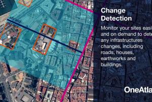 OneAtlas is a collaborative environment to easily access very high resolution imagery, perform large-scale image processing, extract industry specific insights and benefit from Airbus assets to develop solutions. The services include infrastructure change detection, vehicle detection & counting and will soon cover aircraft detection and land use change detection as well . Airbus provides the services through a buy-what-you-need option. It is possible to test the functionalities with a 30-days Free Trial.Publishing institution:
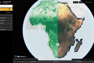 The Digital Earth Africa (DE Africa) Map is a website for map-based access to spatial information. It’s is still being developed by Data61 CSIRO in collaboration with Geoscience Australia. DE Africa is leveraging international Earth Observation (EO) data and science to produce new information and services that benefit African countries. Through translating data into ready-to-use insights, more informed decisions about soil and coastal erosion, agriculture, deforestation, desertification, water quality and changes to human settlements can be made. The data is organized in data-cubes and will be fully available by 2020.Publishing institution:
 Flood hazard assessments are critical to identifying areas at risk and taking relevant preparation and mitigation measures to address the hazard. Using the HEC-RAS 2D model for preparing flood hazard maps, this Recommended Practice explains how to identify flood-prone areas and exposed infrastructure. Through its focus on the prevention and mitigation stages of the disaster management cycle, it complements the Recommended Practice on Flood Mapping and Damage Assessment with Sentinel-2, also developed by SUPARCO.Regional Support Offices mentioned:
The 2019 rainy season in the Far North region of Cameroon has caused the Logone river to overflow and flood the Zina (Logone-et-Chari department), Maga and Kai-Kai districts (Mayo Dany) in the country's Far North region. The United Nations Office for the Coordination of Humanitarian Affairs reports that at least 60 out of 110 villages in the Zina district - 19,359 people - are affected, while 15 villages with a total of 16,215 people are affected in the Kai-Kai district.
UN-SPIDER has requested the activation of the International Charter Space and Major Disasters for the floods on behalf of the Department of Civil Protection (DPC) of Cameroon. SERTIT is acting as the project manager for this activation. An…
read more19/10/2019
The 2019 rainy season in the Far North region of Cameroon has caused the Logone river to overflow and flood Zina district in the Logone-et-Chari department. According to media reports, the floods have left at least 100.000 people on both sides of border between Cameroon and Chad. While the rainy season in Cameroon typically takes place between May and September, this year's heavy rains have continued throughout October.
UN-SPIDER has requested the activation of the International Charter Space and Major Disasters for the floods in Cameroon on behalf of the Department of Civil Protection (DPC). SERTIT is acting as the project manager for this activation.
In July 2019, UN-SPIDER conducted an Institutional Strengthening Mission to Cameroon and ran a workshop focussing on making…
read more
UN-SPIDER Regional Support Offices with hazard-specific expertise
![]()