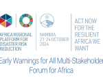
From 20th to 24th October, the United Nations Office for Disaster Risk Reduction (UNDRR), the African Union Commission (AUC), the Southern African Development Community (SADC), and the Republic of Namibia are organizing the 9th Session of the Africa Regional Platform for Disaster Risk Reduction in Windhoek, Namibia.
On 15th October, the European Space Agency (ESA) officially kicked off their new project, Ciseres, at the International Astronautical Congress (IAC) in Milan. Ciseres is a small satellite mission integrating AI directly into the process of identifying relevant information in satellite imagery. Users are provided with rapid “actionable” information within just a few minutes.
“AI-powered Satellite systems will redefine how we respond to disasters” (CEO of Deimos).
This is event is available for participation on an ongoing basis
Synthetic Aperture Radar (SAR) has the capability to observe the Earth's surface both day and night and through most weather conditions, making it an ideal sensor to support a wide range of science and applications. Additionally, unique capabilities of SAR include its ability to penetrate through various mediums (such as vegetation, snow, and soil), measure surface deformation and small movements on the order of centimeters, and its sensitivity to structure and to moisture content.
Disaster response efforts benefit substantially from the use of information on the geographical extent of the hazard that triggered the disaster. For example, maps of the geographical extent of floods allow disaster managers to become aware of all the communities and assets that may have been affected.
In March 2015, 187 Members States of the United Nations launched the Sendai Framework for Disaster Risk Reduction 2015-2030. The framework called for the implementation of efforts at the local, national, regional, and international levels to confront the challenges posed by natural and anthropogenic hazards. Targets included a substantial reduction in global disaster risk mortality, the number of affected people, disaster-related economic losses, and impacts to critical infrastructure.
Nigeria's Minister of Innovation, Science, and Technology, Uche Nnaji, commented that the threat of flooding has significantly decreased according to recent data from the Nigeria Hydrological Services Agency (NIHSA) and from the National Space Research and Development Agency (NASRDA). The collaboration between NIHSA and NASRDA is geared to monitor Lagdo Dam to adopt preventive measures to protect individuals from potential flooding in case flood gates are open by the Dam operators.
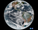
The National Oceanic and Atmospheric Administration (NOAA) has released the first photographs collected by its GOES-19 satellite, which provide a nearly constant view of the Western Hemisphere. GOES-19, the most recent addition to NOAA's Geostationary Operational Environmental Satellites (GOES) network, was launched on 25 June 2024. The Advanced Baseline Imager (ABI) on GOES-19 takes data throughout 16 channels of the electromagnetic spectrum, including the visible, near-infrared, and infrared bands.
This is event is available for participation on an ongoing basis
The Summit is a high-level event, bringing world leaders together to forge a new international consensus on how we deliver a better present and safeguard the future.
Effective global cooperation is increasingly critical to our survival but difficult to achieve in an atmosphere of mistrust, using outdated structures that no longer reflect today’s political and economic realities.
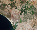
The Sentinel-2C satellite has started providing imagery of Earth only two weeks after launch, demonstrating the capabilities it will offer to the Copernicus program, the Earth observation endeavour in Europe. Having been launched from Europe’s Spaceport in French Guiana on September 5, 2024, Sentinel-2C will provide continuous high-resolution multispectral imagery of Earth’s land, inland waters, islands, and coastal areas.