![]()
United
Nations
Forest Fire
, processed by ESA, CC BY-SA 3.0 IGO.")
Definition
Facts and figures
Further information
UN-SPIDER Regional Support Offices with hazard-specific expertise
Related content on the Knowledge Portal
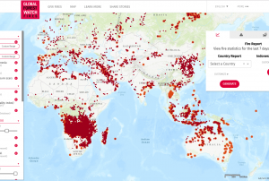 The Global Forest Watch Fires is a dynamic online forest monitoring and fire alert system that provides near real time information to enable people to better combat forest and land fires before they burn out of control.Publishing institution:
The Australian Flammability Monitoring System is a new vegetation condition and flammability online mapping tool that is expected to support fire and land managers in Australia.
The mapping tool uses satellite data to collect information on moisture content in highly flammable vegetation such as fallen bark, leaf litter and grass. It then displays this information on an interactive map, which will help fire managers in determining burning efforts and preparing of firefighting resources.
A team of researchers from the Australian National University (ANU) developed the monitoring tool - the first web-based system of its kind in Australia - as part of the Mapping bushfire hazards and impacts research project with the Bushfire and Natural Hazards CRC.
… read more20/09/2018 of 2.7 m (i.e., less than one floor) and the share of built-up area could be estimated with a MAE of 13.3 %, when compared to a reference data set.") Publishing institution:
Publishing institution: Derived products from various satellites processed by agencies in the field of disaster mapping.Publishing institution:
-
Derived products from various satellites processed by agencies in the field of disaster mapping.Publishing institution:
-
Derived products from various satellites processed by agencies in the field of disaster mapping.Publishing institution:
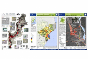
 After the TAM was conducted in Myanmar, innovative impacts were completed following a recommendation. “Emergency Operation Centre (EOC)”, which is comprised of four units including “Remote Sensing Unit” and “Risk Assessment and Emergency Response Unit” was established in the Ministry of Social Welfare, Relief & Resettlement (MSWRR). The capacity building of MSWRR and other related institutes in remote sensing and GIS were strengthened. The Disaster Management Training Centre now conducts courses in remote sensing/GIS. Myanmar has also become the first country in ASEAN to apply for universal access to the International Charter. Myanmar government is aware of the National Spatial Data Infrastructure (NSDI) and one map policy that has been initiated by the Ministry of Education is very crucial.read morePublishing institution:
 ,
, 
In order to encourage the targeted retrieval of space-based information and data by disaster risk reduction practitioners, content on the Portal is systematically enriched with metadata. For instance, data sources are marked up with data about their file type, satellite/sensor and spatial coverage and whether they relate to the disaster risk management or emergency response phase. The tool features a range of filters that draw on the metadata, thereby allowing users to narrow down their search, for example, filtering available GIS software by hazard type. This ensures that users efficiently find the content that is most relevant to them. At the same time, the Portal encourages the discovery of resources related to those accessed by the user, by providing links to them on the same page. This allows for contextualisation and highlights links between resources…
read morePublishing institution: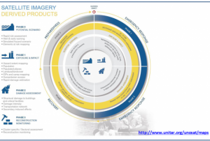 ,
, 
Based on optical and radar images of different resolutions, UNOSAT products are also enriched with the available baseline GIS datasets and crowdsourcing data. Satellite-derived analysis performed by UNOSAT is delivered in the form of GIS Data, Static Maps, Live Web Maps, and Reports, and is then shared with a wide range of end-users such as UN Agencies, International Organizations, and Governments.
Publishing institution: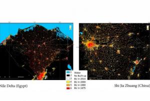 ,
, 
The Global Human Settlement (GHS) framework produces global open source spatial information about the human presence on the planet over time. This is in the form of built up maps, population density maps and settlement maps. This information is generated with evidence-based analytics and knowledge using new spatial data mining technologies. The framework uses heterogeneous data including global archives of fine-scale satellite imagery, census data, and volunteered geographic information. The data is processed fully automatically and generates analytics and knowledge reporting objectively and systematically about the presence of population and built-up infrastructures.
UN-SPIDER Regional Support Offices with hazard-specific expertise
![]()