France

country taxonomy block

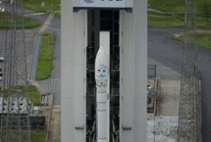
Tomorrow, on Saturday, 4 May 2013 at 03:45 CEST, ESA will launch its new small satellite launcher, Vega, from the Kourou spaceport.

Vega is carrying Proba-V satellite, which will collect data from space on land cover and vegetation changes over the entire globe every couple of days. The two other satellites on board the rocket is an Earth Observation satellite for Vietnam (VNREDSat-1) as well as a nanosatellite build by students in Estonia. VNREDSat-1 is an optical satellite, capable of taking images of the Earth with a resolution of 2.5 metres, build by Astrium.

The launch of Vega tomorrow can be watched live on ESA's livestream. Streaming starts at 03.45 CEST (01:45 GMT) with liftoff scheduled for 04:06 CEST (02:06 GMT) on 4 May. After separation of Proba-V there will be a short break in transmission. Streaming will resume at 05.50 CEST (03:50 GMT), for the release of VNREDSat-1 and ESTCube-1.
Publishing date 03/05/2013

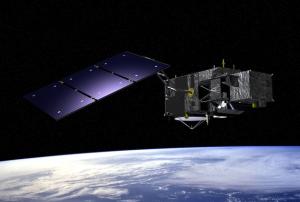
A satellite platform, ESA's Sentinel-3, has been reached an important milestone. It has been delivered to Prime Contractor in France and will be installed and made up for a mission to monitor earth.

Once complete, Sentinel-3 will host an array of a state of the art instruments which focuses on the measurement of different aspects of marine environments and land, as well as atmosphere and cryosphere. The first Sentinel-3 satellite is due to be launched in 2014 and in the second half of this year, it will have its array of instruments installed before going through a stringent testing programme in preparation for launch.

Furthermore, within an operationally robust and sustained near-realtime system, Sentinel-3 will provide policymakers and public authorities with the knowledge required to take decisions with confidence, prepare environmental legislation and policies, monitor their implementation and assess their socio-economic impacts and benefits.


more
Publishing date 07/03/2013

A new era of meteorological satellites under development has begun with a ceremony held at the Palazzo Vecchio town hall in Florence, Italy. This event was an important milestone: the signature of an industrial contract for the provision of four novel lightning imagers.

The challenge of developing the lightning imager instrument now falls to Selex ES under contract from the Meteosat Third Generation (MTG) industrial prime contractor, Thales Alenia Space (France).

The ceremony was attended by Prof. Volker Liebig, ESA Director of Earth Observation Programmes, Alain Ratier, Director General of Eumetsat, Fabrizio Giulianini, CEO Selex ES, Col Luigi De Leonibus, Head of Reparto Meteorologia dello Stato Maggiore Aeronautica, and Patrick Mauté, Senior Vice President for Observation and Science Domain for Thales Alenia Space, France.

Following on from the Meteosat Second Generation satellites, MTG is a cooperative venture between Eumetsat and ESA, and will…

more
Publishing date 08/02/2013

On 16 February, the European Parliament voted on the future of GMES in a resolution that strongly supports the programme being funded within the Multiyear Financial Framework and for it to be operational from 2014. The motion, which was presented in Strasbourg, France, by MEP Norbert Glante on behalf of the Committee on Industry, Research and Energy, was adopted in plenary. In the resolution, the European Parliament urges the European Commissions (EC) to find a suitable solution to have the Global Monitoring for Environment and Security (GMES) programme fully operational from 2014. It highlights that funding the programme outside the Multiyear Financial Framework (MFF) is not considered viable and is, instead, detrimental to the full programme.

In particular, the Parliament reiterates that GMES is one of the European Union’s two flagship space initiatives. It considers that the solution proposed by the EC in its ‘A budget for Europe 2020’ to finance GMES…

more
Publishing date 23/02/2012

The 2019 annual event for researchers and practitioners in integrated disaster risk management (IDRiM) will focus on the issues of “Knowledge-based Disaster Risk Management: Broadening the scope by « Smart Territories » for Sustainable and Resilient Cities and Organizations”.

The main themes of “Smart” are related to integrating the “knowledge society and knowledge economy, sustainable development, and social inclusion”, with complexity theory, such as, for example, the important role of interconnectivity of networks and feedback effects. How and when this connectivity becomes positive or negative is both a challenge for “hard” sciences (e.g. what are the formal methods that provide valid tools to assess the efficiency of networks, as in see graph theory) and “soft” sciences in the field of risk, resilience and disasters (e.g. participative and deliberative governance frameworks).

The IDRiM2019 conference brings together researchers and scientists, regulators, risk…

more

The International Society for Photogrammetry and Remote Sensing is a non-governmental organization devoted to the development of international cooperation for the advancement of photogrammetry and remote sensing and their applications.

The topics of the Conference include:

  • Sensors and constellations for Earth observation

  • Spatial, spectral and temporal analysis of image and range data

  • Industrial, heritage, space, underwater and environmental applications

  • Applications in landuse/landcover, nature resources, weather/atmosphere and climate, cryosphere, coastal and ocean, forestry/agricultural and ecosystems/biodiversity

  • Innovative Geospatial technologies for infrastructure planning and assets mapping

The 4th GEO Blue Planet Symposium will serve as a forum for discussion of ocean and coastal information needs for sustainable development, Blue Growth and societal awareness. The symposium will bring together producers of ocean and coastal information and current and potential users of ocean and coastal information, who will share their experience with the audience.

The goal of the GEO Blue Planet Initiative is to ensure the sustained development and use of ocean and coastal observations for the benefit of society. We do this by promoting collection of continuous ocean and coastal observations, processing of data into information and linking this information with societal needs. The societal needs feed back into ocean and coastal observation requirements and enhancement or modification of the ocean and coastal observation strategy. This requires close working relationships between scientists who collect ocean and coastal observations, those that take these observations and…

more

The ISAE-SUPAERO school, a global leader in higher education focusing on aerospace engineering, will be conducting a four week training certificate on Earth Observation for End Users.  The training certificate will be offered during the month of April 2017, and will be offered on an annual basis in April. 

The training certificate include four topics:

1 - Earth observation systems;

2 - Scientific, environmental and social issues;

3 - Business and services; and

4 - Law, intelligence and international issues.

For more information you may contact Mr. Emmanuel Zenou, Head of the Programme (emmanuel.zenou [at] isae-supaero.fr;  tel.: +33 5 61 33 81 30)

For information on admissions, you may contact Ms. Marie Jentet-Guibbal (marie.jentet [at] isae-supaero.fr;  tel. +33 5 61 33 80 28)

The 21st session of the Conference of the Parties to the United Nations Framework Convention on Climate Change (UNFCCC), or COP21, will be held on the Paris-Le Bourget site, bringing together around 40,000 participants in total - delegates representing each country, observers, and civil society members. It is the largest diplomatic event ever hosted by France and one of the largest climate conferences ever organized.

The aim of the conference is to achieve a legally binding and universal agreement on climate, from all nations of the world and boost the transition towards resilient, low-carbon societies and economies.

more

Floods cause distress and damage wherever they happen and flooding from rivers, estuaries and the sea threatens many millions of people in Europe. Insurance losses from flooding have increased significantly since 1990 and flood management in Europe is changing with a move from flood protection and defence to comprehensive flood risk management.


FLOODrisk 2016 will explore research advances in flood risk analysis and innovations in flood risk management practice. The conference will consider all aspects of flood risk and will cover the causes of floods, their impacts on people, property and the environment, and portfolios of risk management measures. FLOODrisk 2016 is also supported by the Flood Risk Management Research Consortium.

Topics

Theme 1 Characterising the flood hazard

• Probability from all sources
• Climate change
• Multi-hazard
• Data, analysis and modelling

Theme 2 Characterising the consequences…

more