Space-based information has been used extensively to contribute to disaster response efforts since several decades ago. To enhance the use of such space-based information, since the year 2001, national space agencies from many countries have joined forces over the years to integrate the International Charter Space and Major Disasters as a mechanism to provide space-based information free of charge to national disaster management agencies and first responders in case of devastating disasters in all regions of the world.
Heatwaves, which can last for several days, impact societies and their livelihoods in many regions of the world. In August of the year 2003, a severe heatwave impacted Europe. According to the Meteorological Office of the United Kingdom (UK MetOffice), this particular heatwave was the worst one in the last 500 years (https://www.metoffice.gov.uk/weather/learn-about/weather/case-studies/heatwave).
Heavy rainfall triggered severe floods in the Southern region of Mozambique, including areas of Maputo. The National Disaster Risk Management Institute (INGC) reported around 37,000 people affected, and contacted UN-SPIDER. At the request of INGC, UN-SPIDER activated the International Charter Space and Major Disasters. The International Charter was activated on 16 February 2023, designating the International Water Management Institute as project manager and INGC as a value-added provider.
In the early hours of 6 February 2023, a major earthquake of magnitude 7.8 struck the sourthern region of Türkiye. The epicentre was located 23 kilometres east of Nurdagi (Gaziantep Province). The earthquake also affected neighbouring Syria and was followed by very strong aftershocks.
This is event is available for participation on an ongoing basis
The evolution of disaster risk has become more complex due to the effects of climate change, advancements in technology and infrastructure, and growing anthropogenic pressures. The impending risks have wide-ranging and long-term implications for societal sustainable development. Under current development pathways, the world should prepare to face the possibility of more compounding hazards and complex risk landscapes in the future brought on by biological, technological, natural, and man-made hazards, of which many are interrelated and self-perpetuating.
This is event is available for participation on an ongoing basis
Climate change is not only changing the location, frequency, and severity of environmental extremes and hazards, but also the baseline spatial and temporal patterns that have served as the basis for land use planning, the design of infrastructure, and the development of construction standards and practices. To anticipate the emerging impacts on communities, we must improve understanding of exposed assets, including the built infrastructure and its characteristics such as structure type, use, occupance, compliance with engineering standards, and replacement cost.
Advanced-level students interested in risk assessment and climate change adaptation, emergency managers, risk modelers, GIS analysts, EO researchers and analysts, Structural Engineers, climate adaptation researchers and planners
This is event is available for participation on an ongoing basis
This ARSET Training will describe climate risk assessment approaches that originate with stakeholder expertise in the fundamental climate vulnerability and exposure of their system. By identifying at-risk assets and the types of climate conditions that drive problematic responses, stakeholders and scientists can co-develop risk information targeting specific climatic impact-drivers and utilizing climate observations and projections sets selected to suitably address those risks.
This training is primarily intended for local, state, federal, and international entities, including public and private sector organizations to use NASA Earth observations and modeled climate projection datasets for integration into their climate change-related work in different sectors.
This is event is available for participation on an ongoing basis
In November 2000, several space agencies joined forces to establish the International Charter "Space and Major Disasters". The International Charter has been set up as a worldwide collaboration through which products generated from satellite imagery are made available free of charge to those responding to disasters in any region of the world. By combining Earth observation assets from different space agencies, the Charter allows resources and expertise to be coordinated. Since it was launched, the Charter has been activated more than 800 times to contribute to disaster response efforts.
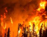
In recent weeks, devastating wildfires have spread in Greece, Italy, Spain, Portugal, Algeria, Tunisia and Canada, causing human casualties as well as massive environmental and economic damage.
While wildfires are a natural part of many ecosystems, scientists have warned that they are becoming more frequent and more widespread. In response, an upgraded version of European Space Agency’s (ESA) World Fire Atlas is now available providing a detailed analysis of wildfires across the globe.
")
")
.")
.")