![]()
United
Nations
Flood
, processed by ESA, CC BY-SA 3.0 IGO.")
Definition
Facts and figures
Further information
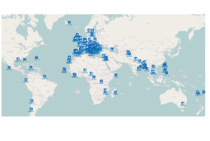
UN-SPIDER Regional Support Offices with hazard-specific expertise
Related content on the Knowledge Portal
 ,
, 
The guidelines will be reviewed and updated periodically, in order to integrate new best practices and to be responsive to evolutions in technology and end-user needs. The IWG-SEM chair has the responsibility to initiate the review, by agreement of the Working Group.
The production and the maintenance of the guidelines are based on a joint effort by the members of the International Working Group on Satellite-based Emergency Mapping (IWG- SEM), a voluntary group of organizations involved in satellite-based emergency mapping. It was founded to improve cooperation, communication and professional standards among the global network of satellite-based emergency mapping providers. The chairperson of the group is nominated for a term of one year and is responsible for organizing the monthly telecons and bi-annual meetings. The current chair is from the Department of Geoinformatics, Z_GIS University of Salzburg / Spatial Services Ltd, Austria…
Publishing institution: ,
,  Publishing institution:
 ,
,  ,
,  ,
, 
Intensive capacity development sessions for Pacific island countries (Cook Islands, Fiji, Kiribati, Micronesia (the Federated States of), Samoa, Solomon Islands, Tonga, and Vanuatu).
The project aims to enhance institutional and technical capacity for using geospatial data and technology applications and promote regional cooperation for sharing geospatial data for disaster management in Pacific island countries.
Publishing institution: ,
,  ,
,  ,
, 
Developed for the needs of the ASEAN sub-region in Asia and the Pacific, the handbooks can also be adapted for use in other regions.
The handbooks have been developed through expert working groups, in collaboration with United Nations partners including UNOOSA/UN-SPIDER, UNITAR-UNOSAT, and OCHA. As well as extensive consultation with space agencies, national disaster management authorities and regional institutions, including GISTDA, LAPAN, ASEAN Coordinating Centre for Humanitarian Assistance on Disaster Management and Asian Institute of Technology.
Publishing institution: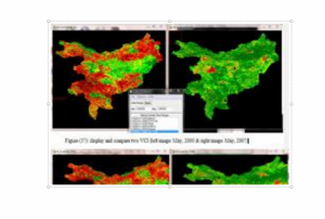 ,
, 
Vegetation Condition Index according to Kogan et al. (1990). Two-weeks normalized Differenced Vegetation Index (NDVI) composites based on 250m MODIS data are freely available for download from the MODIS/NDVI Time Series Database from the Global Agriculture Monitoring (GLAM) Project provided via the website of Geographic Department of Maryland University.
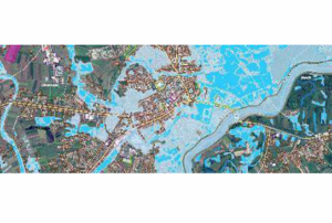
Publishing institution:. The example shows a flood situation in the eastern part of India on September 04, 2016, observed by Sentinel-1 data.")
The automatically derived flood masks are based on Sentinel-1 and TerraSAR-X radar data. TerraSAR-X data can be accessed free of cost via scientific data proposals or are provided by DLR during activations of the International Charter ‘Space and Major Disasters’. Data from Sentinel-1 is accessible free of cost via ESA’s Copernicus Open Access Hub.
read morePublishing institution:") ,
, ") ,
, ")
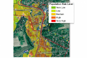
For a comprehensive and objective analysis of the settlement patterns, the DLR additionally developed an approach to display the spatial networks between the mapped settlements. It enables the computation of various form and centrality measures to characterize settlement patterns, at different spatial units, ranging from global to local scale.
Publishing institution: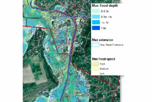 ,
,  ,
, 
CEMS is a core service of the European Union’s Earth Observation programme Copernicus. It supports all phases of the disaster management cycle by delivering warnings and risk assessments of floods and forest fires and by providing geospatial information derived from satellite images on the impact of natural and man-made disasters all over the world (before, during or after a crisis). The two Mapping services of CEMS (Rapid Mapping, Risk and Recovery Mapping) are delivering products since April 2012. The Risk & Recovery Mapping provided for example information for preparedness, disaster risk assessment and risk reduction related to earthquakes in Nepal, several post-disaster assessments for flood and fire events, reconstruction and recovery monitoring in Haiti, and multi-risk assessments for the Azores Islands in Portugal.
CEMS is coordinated by the European Commission (joint coordination between the Directorate Generals ECHO, JRC, GROW). Activation requests…
read morePublishing institution: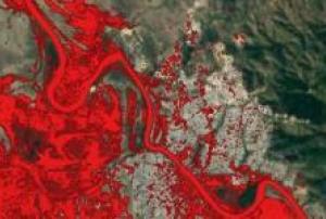 As a means of emergency response after a flooding event or inland inundation, flood mapping helps to estimate the extent of the flood on a large scale. It is a basis of coordinating appropriate recovery activities, rehabilitation and prevention measures for possible upcoming events. This UN-SPIDER Recommended Practice on flood mapping and damage assessment explains the use of Sentinel-2 (S2) optical satellite data from the European Space Agency (ESA), which acquires data in 13 spectral bands. It provides hands-on practice to calculate the Normalized Difference Water Index (NDWI) to determine…Regional Support Offices mentioned:
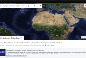
UN-SPIDER Regional Support Offices with hazard-specific expertise
![]()