Recommended Practice: Agriculture Drought Monitoring and Hazard Assessment using Google Earth Engine
Drought is slow on-set disaster which affects agriculture and associated livelihood in many parts of the world. Drought causes stress to vegetation; hence the extent of a drought can be reflected by changes in the vegetation condition. Geospatial scientists have developed drought indices based on remote sensing data to effectively detect drought conditions. The Normalized Difference Vegetation Index (NDVI) is the normalized difference between near-infrared (NIR) and red reflectance. Simple and effective, it is one of the most widely used indices for detecting drought conditions. More recently, many other indices have been developed, such as the Vegetation Condition Index (VCI), which is an indicator of the status of vegetation cover as a function of NDVI minima and maxima encountered for a given ecosystem over many years, or the Vegetation Health Index (VHI), which combines the VCI and land surface temperature.
This Recommended Practice will utilize Google Earth Engine for the preparation of indices. Google Earth Engine is a cloud-based platform and can perform large-scale geospatial analysis to solve real world spatial problems based open-source data. The major advantage of Google Earth Engine is its use of Google’s extensive computational capabilities, resources and datasets, which generally do not require high-performance computing systems at the user end. Therefore, Google Earth Engine appears to be a unique and integrated platform designed to empower not only traditional remote sensing scientists but also a much wider audience that lacks the technical capacity needed to utilize traditional supercomputers or cloud-computing resources.
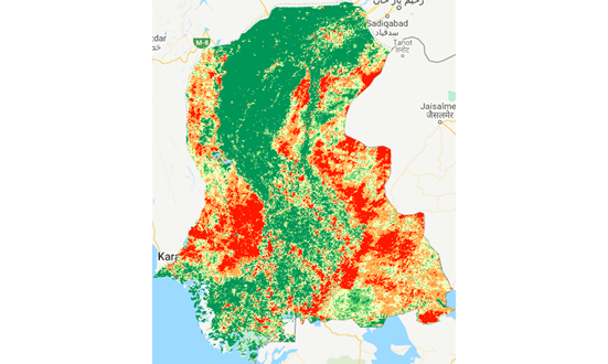
The objective of this practice is to identify the drought extent and severity in the affected region. This information can be used by disaster management agencies and other stakeholders to mitigate, rescue, and relief activities in affected areas.
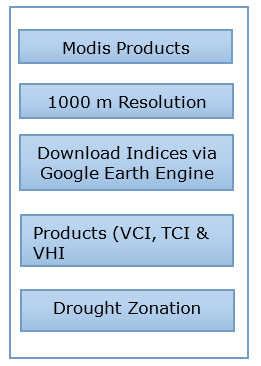
The Recommended Practice was initially applied to the drought-like situation observed in March 2019 using MODIS data for the period 2000 to 2018. The drought affecting the area was extracted from the visible bands (R, G, B, NIR) of MODIS products, which have a 1000 meters resolution, by using Normalized Difference Indices (NDVI, VCI, TCI, and VHI). The resolution can be enhanced up to 500m depending on the spatial extent of AOI.
This practice can be applied to vegetation drought events anywhere in the world.
However, the procedure works best for rainfed agriculture. For irrigated agriculture, the results may not necessarily be satisfying.
Neither UN-SPIDER nor the Regional Support Offices (RSOs) or their partners take any responsibility for the correctness of outputs from this recommended practice or decisions derived as a consequence.