| Organizers | UN-SPIDER and National Disaster Management Organisation (NADMO) |
| Participants | Ghana National Fire Service (GNFS) |
| Centre for Remote Sensing and Geographic Information System (CERSGIS) | |
| Ghana Meteorological Department (G-MET) | |
| Ghana Survey Department (GSD) | |
| Ghana Armed Forces (GAF) | |
| Ghana Irrigation Development Authority (GIDA) | |
| Hydrological Services Department (HSD) | |
| Ghana Police Service (GPS) | |
| Water Resources Commission (WRC) | |
| Ghana Geological Survey Authority | |
| Health Services Department Ghana |
The aims of the UN-SPIDER Institutional Strengthening Mission (ISM) to Ghana were
- To conduct a training course on the use of two UN-SPIDER Recommended Practices: flood extent mapping using Sentinel -1 radar data and drought monitoring using the Standard Vegetation Index (SVI) and the Vegetation Condition Index (VCI)
- To discuss a proposal for NADMO and other government agencies to establish a technical, inter-institutional Earth Observation Team
- To identify potential applications of the Airbus Digital Terrain Model
- To support NADMO in its application to become an Authorised User of the International Charter Space and Major Disasters
The mission consisted of two parts:
Inter-institutional Seminar
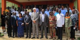
The seminar brought together nearly 50 participants from several government agencies in including NADMO, the Ghana Geological Survey Authority, the Survey Mapping Division, the Police Department, the Land Use Spatial Planning Authority, the Ghana Space Science and Technology Institute, the Ministry of Food and Agriculture, the Ghana Irrigation Authority, the Water Resources Commission, the Ghana Armed Forces and the National Fire Service as well as the Centre for Remote Sensing and Geographic Information Systems of the University of Ghana.
The seminar allowed participants to exchange information on their activities, on joint efforts with NADMO and on the use of remote sensing and geographic information systems in their routine tasks.
Training course
The training course was organized and attended by 25 participants from several government agencies and the University of Ghana. Participants were trained in the use of specific step-by-step procedures to process satellite imagery to map the extent of floods using as an example the recent floods in the White Volta River in the northern region of Ghana. Participants were also trained on the use of another step-by-step procedure to map the comparative impacts of droughts on vegetation in the central region of Ghana. These procedures make use of open satellite imagery and open source software and will enhance the capability of government agencies to generate maps useful to monitor floods and droughts as well as in early warning systems. UN-SPIDER took the opportunity to present to NADMO more than 40 gigabytes of optical and radar, satellite imagery and maps it generated for this mission, covering the entire Republic of Ghana in case of droughts.
- A proposal was successfully made to the International Charter Space and Major Disasters for NADMO to become an Authorised User of the International Charter Space and Major Disasters
- The establishment of an inter-institutional remote sensing and disaster management team called “The Ghana eaRth obsErvATion Technologies Team (GREAT Team)” which will help in designing and managing an Integrated Decision Support System (IDeSS) for disaster risk management and emergency response
- Participants of the four-day training were able to generate their own maps of flood extents which recently occurred on the White Volta River, using radar images from Sentinel-1
- Participants generated more than 400 time series maps from MODIS Terra data for drought monitoring using the Standard Vegetation Index (SVI) and Vegetation Condition Index (VCI) methods
Mission Outlook
- NADMO to carry out two additional training courses with the support of the Ghana Space Science and Technology Institute and the Centre for Remote Sensing and Geographic Information Systems of the University of Ghana to strengthen the skills of the team. These two training courses should give team members a better overview of the software tools used in the procedures (SNAP software developed by the European Space Agency and R Studio).
- The technical Inter-Institutional Team to start the routine generation of maps of the Vegetation Index or the Standard Vegetation Index to track areas that may be affected by drought and incorporate this procedure into the drought early warning system.
- The Technical Inter-Institutional Team to elaborate additional maps of the floods that took place in August and September 2018 and their evolution and discuss how to use this historical information to improve disaster preparedness efforts on the basis of this and other floods.
- NADMO to assess the feasibility of working with UN-SPIDER and Airbus in the generation of maps of areas susceptible to landslides and to tidal waves or storm surges.
- NADMO to complete the steps regarding the incorporation of NADMO as an Authorised User of the International Charter Space and Major Disasters.