![]()
United
Nations


Estimate Hectares of Forest Destroyed or Damaged by Fire for the Sendai Framework Indicator C-2Fo: In Detail
The Sendai Framework
The SFDRR was adopted at the Third UN World Conference in Sendai, Japan, on March 18, 2015. The framework aims to achieve the substantial reduction of disaster risk and losses in lives, livelihoods and health and in the economic, physical, social, cultural and environmental assets of persons, businesses, communities and countries over the 15 years leading to 2030. More information on the Sendai Framework is available here.
The framework sets four priorities for action and seven global targets to reduce the risk of disasters and to avoid the increase in the level of existing risks. The seven targets are assessed through a set of 38 indicators. Government officials and relevant stakeholders involved in monitoring national progress have been designated to report on in the SFM, to support the assessment of global progress in the reduction of risk and losses. Country coordinators also have the option to add custom indicators and targets, which are nationally defined instruments to measure the implementation of the Sendai Priorities, to support states in reporting the relevant data they have.
SFDRR Sub-indicator C-2Fo/C-2Foa of Target C
Target C of the SFDRR has been incorporated to reduce direct disaster economic loss in relation to global gross domestic product (GDP) by 2030. It refers to economic losses to the agricultural sector, productive assets, housing sector, critical infrastructure, and cultural heritage.
Indicator C-2 measures the impact of disasters on agricultural production and assets. As agriculture is understood to include the crops, livestock, fisheries, agriculture, aquaculture and forest sectors as well as associated facilities and infrastructure, C-2 is the sum of five sub-indicators. Sub-indicator C-2Fo measures loss in forests damaged or destroyed by disasters.
Full reporting for the Target C indicators would require data collected from different government ministries, agencies, and/or other relevant stakeholders such as Non-governmental organisations (NGOs). It is likely that the ministry/agency responsible for national forest management would be responsible for collecting the data that states need to report on sub-indicator C-2Fo.
However, reporting country data on economic loss in forest damaged or destroyed by disasters may not be feasible, especially in developing countries which experience frequent forest fires over large areas. This was highlighted in the Sendai Framework Data Readiness Review conducted in 2017, in which 87 countries participated, which found that no single country has all the data required to report on all the targets, and that datasets on economic losses are less available than physical damage and human impact indicators. In countries where there is no methodology to assess economic loss of forests, the TGN therefore specifies that a physical damage indicator, C-2FOa, which measures the number of hectares of forests damaged/destroyed by disasters (disaggregated by hazard) will be accepted in lieu of the corresponding estimated economic loss.
In Detail: acccesing data for C-2Fo (Fires)
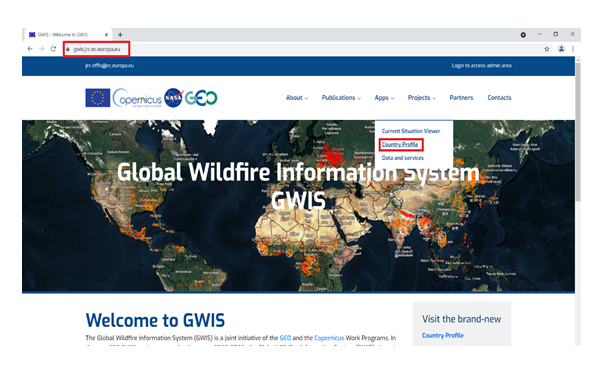
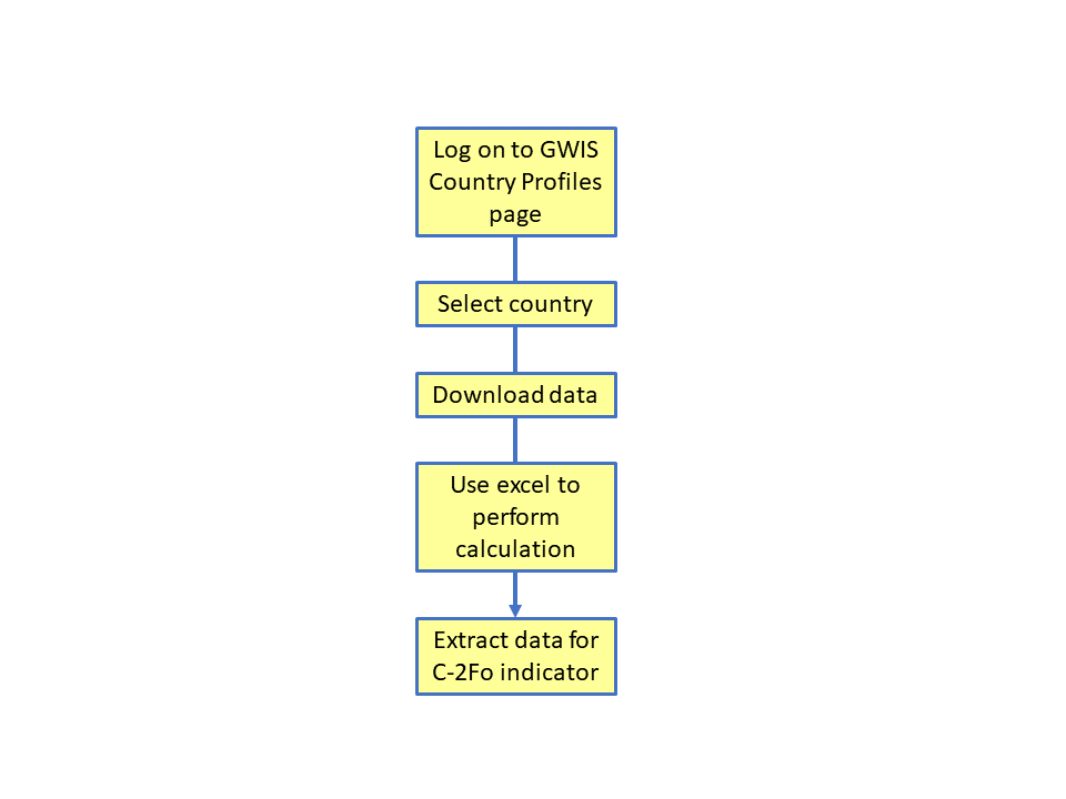
1. Go to GWIS using the following URL: https://gwis.jrc.ec.europa.eu, and select the option Country Profiles under the Apps drop-down menu in the main navigation panel (see figure 1).
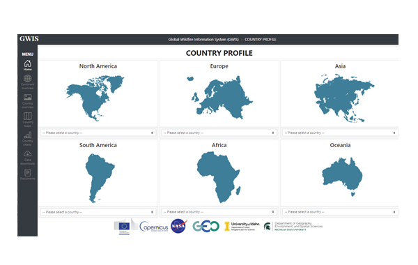
2. Once the new window appears displaying the different regions of the world, select the desired country (Bolivia for example) under the region of interest (e.g. South America) from the drop-down list, and scrolling down to the desired country of interest (see figure 2).
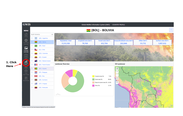
3. After selecting the desired country, the landing page of the desired country appears presenting general data on the country. Click on the "Country charts" menu on the left margin to proceed (see figure 3). It may be that initially, this option appears with a dark grey color font. Nevertheless, it is selectable when clicked and will turn to white color font.
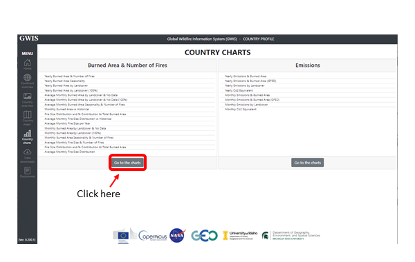
4. A new window will pop up presenting two tables of data. Click on the "Go to the charts" button at the bottom of the left table (see figure 4).
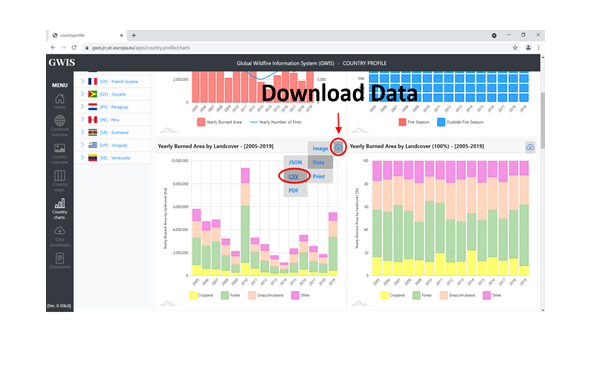
5. Once the new window pops up, slide the circle in the top left slide bar to span the period from the year 2005 to 2019. Then scroll down to the graph entitled ‘Yearly Burned Area by Landcover – [2002-2019]’. Hover over the download icon, and download the data as CSV (see figure 5).
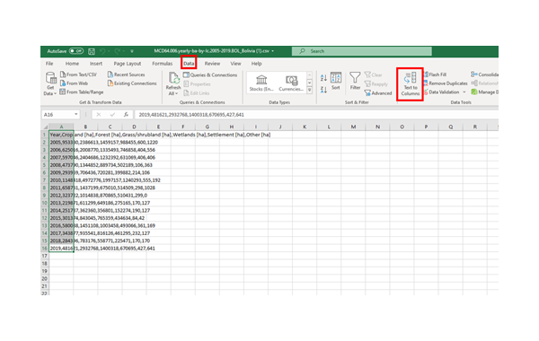
6. Open the excel file that was downloaded. The file name will start with ‘MCD64.006’, referring to the MODIS Collection 6 burned area product MCD64 A1 from which burnt area statistics are computed. MODIS (or Moderate Resolution Imaging Spectroradiometer) is a key instrument aboard the Terra and Aqua satellites. These two satellites are viewing the entire Earth's surface every 1 to 2 days, acquiring data in 36 spectral bands, or groups of wavelengths. The data presented in GWIS employs a combination of daily 500m MODIS surface reflectance and 1km MODIS active fire observations, and applies dynamic thresholds to composite Terra and Aqua imagery generated from a burn-sensitive vegetation index from MODIS 1240 and 2130 nanometer bands and a measure of temporal variability (GWIS, 2021). The algorithms’ coupled use of active-fire and reflectance data enables it to adapt regionally and over varied ecosystems, and performs substantially better in reducing the number of unclassified grid cells due to cloud contaminated observations compared to the heritage Collection 5.1 MODIS products (Giglio et al, 2018).
Note that the data being opened from a csv file will appear in one single column in Excel at first (see figure 6). Select the "Data" menu at the top, then select all data in column A, and use the ‘Text to data‘ function and follow the Convert Text to Columns Wizard‘s instructions.
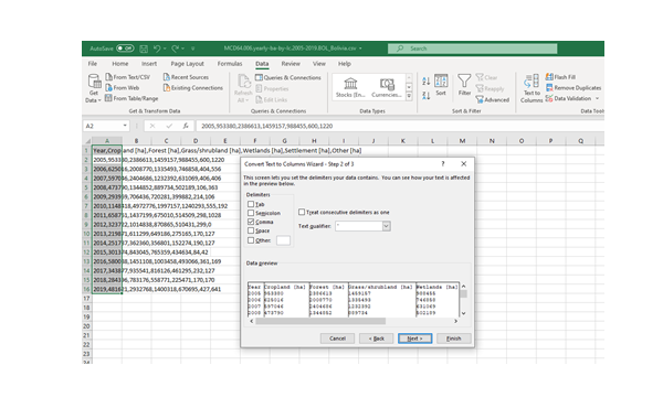
A new pop-up window will appear with options for this transformation. Make sure to use the right delimiter, which is comma in this case and click finish (see figure 7).
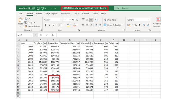
After the transformation from csv data has been completed, the values corresponding to the total burnt area in hectares of forest for years 2015 onwards can be reported as physical damage indicators under sub-indicator C-2Fo. In the SFM, select data entry option ‘Enter hectares manually & monetary value to be calculated’, and the system will calculate an estimate of corresponding economic loss. To include grasslands in C-2Fo reporting, add the yearly values for burned grass/shrubland to those for forests (see figure 8).
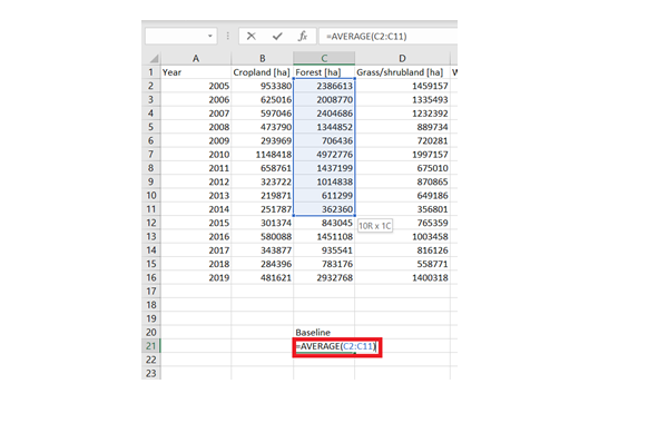
7. Member states are encouraged to include baseline data for Target C for improved analysis of progress over time. To calculate the mean annual burned area for the period for 2005-2014 in Excel, use the AVERAGE function and select cells corresponding to yearly burned area between the years 2005 and 2014 (see figure 9).
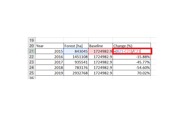
8. To calculate percentage change in any year relative to the baseline, first create a table similar to the one that can be seen in figure 9, containing the data related to the years 2015-2019 and the value for burned forest area and the baseline that was calculated earlier. Subtract the baseline value from the number of hectares burned for any year, and divide by the baseline. Ensure the cell format is converted to ‘Percentage’ (see figure 10).
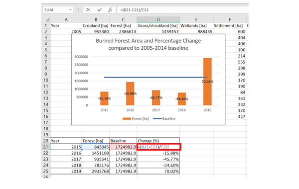
In the example below, we can see that Bolivia experienced a 70.2% increase in number of hectares forests damaged/destroyed by fires in 2019 compared to the 2005-2014 (pre-Sendai) baseline. A chart can be created to present the data for the years 2015 to 2019 in relation to the 2005-2014 baseline as shown in figure 11.

![]()