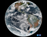
Copernicus Newly Launched Coastal Hub

The coastlines of the world host a rich mix of dense populations, varying industries, and environmental characteristics that are collectively influenced by both land and sea. To facilitate the production of knowledge and data products regarding these complex coastal regions, the European Commission under the Copernicus program has developed a new online resource: The Copernicus Coastal Hub. The Coastal Hub offers a singular resource for data related to coastal regions including examples of use cases and an interactive data and map viewer.

UN-SPIDER/ECLAC/International Charter Training Course for Latin America

This is event is available for participation on an ongoing basis

As in the case of other regions of the world, Latin America is exposed to various types of geological and hydro-meteorological hazards which trigger disasters.  To contribute to strengthen the skills of professionals that contribute to disaster response efforts through the generation of space-based information, UN-SPIDER, ECLAC and the International Charter Space and Major Disasters organised the training course "Project Management using the ESA Charter Mapper".   The training course brought together 15 professionals with skills in project management in case of activ

0
0
Professionals with skills in project management in case of activations of the International Charter
No certificate issued or not known
0.00
USD
11/07/2023, 12:00am - 11/09/2023, 12:00am
not visible
Santiago de Chile

International Charter Space and Major Disasters

ECLAC

UN-SPIDER

Spanish

Introductory Webinar: Introduction to Lightning Observations and Applications

This is event is available for participation on an ongoing basis

It is well-documented that there are approximately 24,000 worldwide fatalities from lightning each year, with about 10 times more being injured from lightning (NIH-NCBI). In addition, lightning strikes are one of the leading causes of wildfire ignition. During storms, lightning strikes on trees, utility poles, and infrastructure, can damage power lines resulting in power outages. Lightning flashes also generate electromagnetic fields (Sferics) that interfere with electrical devices on ground.

0
0
No certificate issued or not known
0.00
USD
03/26/2024, 12:00am - 04/02/2024, 12:00am
not visible

NASA ARSET

1

UN-SPIDER/ASAL/ZFL Workshop: Space-based Solutions for Forest Fires in Algeria

This is event is available for participation on an ongoing basis

Introduction

In recent decades, communities in Africa have experienced disasters triggered by floods, droughts, landslides, forest fires, Ebola pandemics, and locust plagues that have eroded hard-won development gains. Taking note of advances in space technologies and other technological innovations, the African Union indicated in its 2017 African Space Policy that space represented a unique opportunity for cooperation in using and sharing enabling infrastructure and data towards the proactive management of, inter alia, responses to natural hazards and disasters.

0
0
No certificate issued or not known
0.00
USD
11/21/2023, 12:00am - 11/22/2023, 12:00am
not visible
Centre International de Conferences
Algiers

Algerian Space Agency (ASAL)

Center for Remote Sensing of Land Surface (ZFL), University of Bonn

UNOOSA / UN-SPIDER

Arabic
1
French
NASA's PACE Satellite Successfully Launched to Study Ocean Health and Climate

NASA's latest satellite mission, the Plankton, Aerosol, Climate, ocean Ecosystem (PACE), has been launched into orbit, marking a significant step in understanding crucial aspects of Earth's health and climate dynamics. PACE's primary objective is to examine the interplay between various components of Earth's systems, focusing on oceans, atmosphere, and climate.

martin.hilljegerdes Mon, 12 Feb 2024 - 15:10

3rd International Conference Natural Hazards and Risks in a Changing World

This is event is available for participation on an ongoing basis

From 12-13 June 2024, the 3rd International Conference on Natural Hazards and Risks in a Changing World: Addressing Compound and Multi-Hazard Risk will take place in Amsterdam, the Netherlands. The conference is organised by MYRIAD-EU, Risk KAN and NatRiskChange.

0
0
No certificate issued or not known
0.00
USD
06/12/2024, 12:00am - 06/13/2024, 12:00am
Visible
Amsterdam
UNOOSA 2024 Space4Youth Essay Competition

Description

The United Nations Office for Outer Space Affairs (UNOOSA), in collaboration with the Space Generation Advisory Council (SGAC), launched the fifth edition of the Space4Youth Essay Competition! The Competition targets students and young professionals with the aim to highlight governance practices and experiences on the sustainable use of outer space to address the needs of the present in a manner that protects the interests of future generations.

martin.hilljegerdes Tue, 23 Jan 2024 - 09:22

University of Glasgow Research: Satellite Analysis of Rivers Could Provide Improved Flood Warnings

Scientists at the University of Glasgow have pioneered a method for monitoring river flows using satellite analysis, offering an advanced early warning system for flood risk. Current methods rely on expensive and challenging-to-install stream gauges, limiting coverage, especially in remote areas. The Glasgow researchers utilized video footage from a Chinese satellite to measure river discharge during a February 2022 flood along a 12-mile section of Australia's Darling River.

UNOOSA, Costa Rica, and PSIPW jointly organize the Sixth Conference on the Use of Space Technology for Water Management

The United Nations Office for Outer Space Affairs (UNOOSA), the Government of Costa Rica, and the Prince Sultan Bin Abdulaziz International Prize for Water (PSIPW) are jointly organizing a conference to promote the use of space technology in water management to the benefit of developing countries.

martin.hilljegerdes Tue, 16 Jan 2024 - 13:10

Introduction to Google Earth Engine (GEE) for Remote Sensing Analysis

This is event is available for participation on an ongoing basis

Google Earth Engine (GEE) is an example of a cloud-based image service that combines an extensive archive of satellite imagery, historical and current, with application programming interfaces (APIs) that allow analysis to be performed on this imagery without having to move it to the user’s desktop.

Want to learn more about this?

The AgroInformatics Team from the Digitalization and Informatics Division (CSI) of the FAO is launching a new series of interactive trainings, on “Introduction to Google Earth Engine (GEE) for remote sensing analysis”.

0
0
The course is dedicated to beginner users that want to understand how to write scripts in Google Earth Engine
No certificate issued or not known

A minimum understanding of remote sensing principles is recommended, familiarity with scripting languages is a plus.

0.00
USD
01/18/2024, 12:00am - 05/02/2024, 12:00am
not visible