![]()
United
Nations
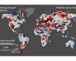
New NASA-led Study Proves Strong Link between Global Warming and Worldwide Intensity of Extreme Wet and Dry Events
 nuria.alonso
Fri, 17 Mar 2023 - 11:09
nuria.alonso
Fri, 17 Mar 2023 - 11:09
NOAA Satellites Play Crucial Role in Preparing for Severe Weather
 deniz.maktav
Wed, 15 Mar 2023 - 23:45
deniz.maktav
Wed, 15 Mar 2023 - 23:45
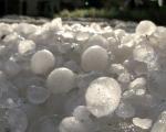
Detecting hailstorms from space - a new method
 nuria.alonso
Tue, 14 Mar 2023 - 09:42
nuria.alonso
Tue, 14 Mar 2023 - 09:42
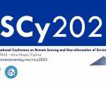
9th International Conference on Remote Sensing and Geoinformation of Environment (RSCy2023)
nuria.alonso
Thu, 9 Mar 2023 - 13:08

![]()