![]()
United
Nations


Step-by-Step: Flood Mapping with Sentinel-1 Interferometric Coherence
The Step-by-Step Explanation is also available as a PDF, which can be downloaded.
1. Downloading the Scenes from the Alaska Satellite Facility
The Alaska Satellite Facility (ASF) downlinks, processes, archives, and distributes remote-sensing data to scientific users worldwide. It is a convenient platform to download Sentinel-1 SLC data:
Each scene has 4 to 5 GB. Based on your AOI, one orbit should be selected, in which all scenes are located. Three S-1 Scenes are necessary: two pre-event scenes and one post-event scene. The scenes need to be of file type L1 Single Look Complex (SLC).
Drawing the AOI:
After loading the page, you can directly start drawing your AOI. Then use the “Filters” option to select the date range. Under “Additional Filters” select “L1 Single Look Complex (SLC)” as file type. If you already know the path, specify it in the section “Path and Frame Filters”.
How to use the Filters:
Select Start Date and End Date: they should be apart by at least one month, end date should be shortly after the disaster happened.
File Type: select L1 Single Look Complex
Path and Frame filters can be specified later
Click „Apply“

After clicking on apply, you will see the scenes (in blue) covering your AOI (yellow/orange). By hovering above the unique rectangles, you will see to what extent they cover your AOI (red). Decide for one rectangle and click on it. In the scene list, you will see it highlighted. You will also see the Path and Frame of the Scene. Use these numbers to go again into “Filters” and add them to path start/end and frame start/end. After clicking again on SEARCH, you will only see one rectangle left on the map.
All three scenes need to be in the same rectangle, i.e., they need to have the same path and frame!


Now, with the shopping cart icon you can add the three scenes to the download section.

In the download tab, you can start the download of the scenes, by clicking on the cloud icon. This will take some time as each scene has between 3 to 5 GB.
So please make also sure that there is enough disk space available on your computer.
2. Processing the Scenes with a pre-defined workflow in SNAP
Drag and Drop the three Scenes (zipped) into the Product Explorer Window in SNAP.
Click on the Graph Builder tool in the tool bar. On the bottom of the Graph Builder Window, click on „Load“. Browse to the directory, where you stored the Coherence.xml file. Double click to open it.
![]()

This is how the loaded Graph should look like. Essentially, this is a processing pipeline, for the three input SLC scenes.
The individual processing steps in the blue boxes can be also found in the normal task bar.

A few things need to be selected manually in the graph window:
For the three Read tabs, the Sentinel-1 scenes need to be selected. This has to be in the right order:
Read = Pre-Event 1
Read(2) = Post-Event
Read(3) = Pre-Event 2TOPSAR-Split Tab, select the Subswath and the bursts. The positioning of the subsets can be seen in the map on the bottom of the window. Apply the same selection to all the TOPSAR-Split tabs (2) and (3).

TOPSAR Split (In Detail)

https://step.esa.int/docs/tutorials/S1TBX%20TOPSAR%20Interferometry%20with%20Sentinel-1%20Tutorial_v2.pdf
Sentinel-1 scenes, that can be used for interferometry, are captured in three sub-swaths (IW1, IW2, IW3), using Terrain Observation with Progressive Scans SAR (TOPSAR). Each sub-swath image consits of a series of bursts, where each burst is processed as a separate image.
That is why we first split the scene, and later deburst it, i.e. put it back together into one image with the TOPSAR Deburst tool.
A few things need to be selected manually in the graph window:
In the Terrain-Correction Tab, you can control the output layers, which should be named:
coh_IWx_VV_pre-Event2_pre-Event1
coh_IWx_VV_pre-Event2_post-Event
If you also selected the VH polarization, two more layers will appear with VH instead of VV in their names.
If the dates are switched, go back to the Read Tabs, and control the selection order described in step 4.

A few things need to be selected manually in the graph window:
In the Write Tab, select the destination directory, to write the output to.
Click on Run.
The execution and the calculation of the coherence will take some time. Depending on your computation capacity, it can take up to a few hours.
If the graph does not work, you can also execute the steps individually in SNAP. You will need more storage capacity on your machine for that, as interim products need to be stored after each step.
Apply Orbit File (10 min)
S-1 TOPS Split (select only VV polarization, up to 3 bursts in one IW swath)
Coregistration: S-1 Back Geocoding (DEM: COP-30; uncheck “Mask out areas with no elevation”)
Coherence Estimation (square pixel size?)
Deburst
Speckle Filtering (median filter?)
Terrain Correction (DEM: COP-30, Map projection: Auto UTM, include layover shadow mask as output band)
3. Exporting the Coherence GeoTIFF
After the processing has finished you can close the graph builder window. In the product explorer window on the left, you will find a new product [4], called
S1A_IW_SLC__1SDV_xxxx_xxxx_xxxx_xxxx_xxxx_Orb_Stack_Coh_Deb_ML_TC
Click on the product, then go to File on the Task bar and select Export. Select GeoTIFF. Choose a directory for your export and click Export Product.
4. Importing the Coherence raster into Google Earth Engine
Open the following Google Earth Engine Script:
In the left panel, go to the Assets Tab, click on the red NEW button, under Image Upload select “GeoTIFF (.tif,.tiff) or TFRecord (.tfrecord + .json).”
Select the exported tif from the previous step, by clicking on SELECT and give a name to the file under Asset Name. Click on UPLOAD.
Under tasks, you will see the upload progressing. Afterwards click on “Run.”


Under the Assets tab on the left side, you will see your raster under CLOUD ASSETS. If it does not show up, click on the Refresh Icon.
By hovering above the file, you will see an arrow, by clicking on which, you can import the raster into the script.

In Detail: Flood Mapping with Sentinel-1 Interferometric Coherence

Downloading the Scenes from the Alaska Satellite Facility
Processing the Scenes with a pre-defined workflow in SNAP
Exporting the Coherence GeoTiff
Importing the Coherence raster into Google Earth Engine
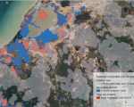
Change Detection in Urban Areas
Map of flooded/damaged areas
Step-by-Step: Flood Mapping with Sentinel-1 and Sentinel-2 Imagery and Digital Terrain Models
Before the Flood
There are multiple steps in this practice, you can already perform before a flood hits your Area of Interest (AOI). This will help you to safe crucial time during the disaster, to ensure a rapid response.
1. Create your AOI on GFM
First, make a user account on GFM: Global Flood Monitoring.
To access the data, you need to create an AOI, which will be stored in your GFM account. You need to assign a name and a description to your AOI. Then click on “Next step”.
In the next step, you can choose between giving the Coordinates to your AOI, drawing the AOI or selecting a region. Most of the time, drawing the AOI is the best idea. Therefore, select the square to the right of the panel, draw the AOI and select Save AOI.


2. Check GloFAS regularly
To know when floods are likely to hit your region, check GloFAS regularly. Check if there are any unusually high precipitations forecasted.
3. Download the FABDEM of your AOI
The FABDEM is a 30m open-access Digital Terrain Model. You can find all necessary information in this Data Application of the Month or in this Scientific Publication: https://iopscience.iop.org/article/10.1088/1748-9326/ac4d4f/meta.
Among other options, FABDEM can be downloaded with Google Earth Engine. With the link below, you can download the FABDEM for your AOI. By clicking on the rectangle tool, you can draw a polygon of your AOI. Then you can click on Run, to run the script. Under tasks, you will see FABDEM popping up. Click on RUN. When the task is finished, you can download the DTM from your Google Drive.
Using other DTMs, for example a high-resolution national DTM or commercial DTMs is also possible. The spatial resolution and accuracy of the DTM is one of the key points to the success of this practice.


https://code.earthengine.google.com/78b037560aa4567b5d950d228531844f
4. Setup Python
This is a step-by-step procedure to setup the Python environment, in which the FLEXTH algorithm will work. If you already have a Python installation on your computer, it still makes sence to follow this guide, to ensure all libraries are installed properly.
We need to install the latest version of Miniforge, which is a light-weight Python distribution. Follow this Link, which leads you to a repository storing the Miniforge3 installers for the different operating sytems (OS). If you are using a Windows 64bit machine, click on „latest“ in the respective row. On the next page look for „Miniforge3-Windows-x86_64.exe“. Click on the link to download the executable.


Double clicks the executable to start the setup. In the setup menu, click on „Next“ , then on „I agree“. Install for „Just Me (recommended)“.
For the Install Location, you can just go with the default folder. Click „next“. For the Advanced Installation Options, you can also go with the default selection. Click „install“.
After the installation click „next“ and then „Finish“. Open the Miniforge Prompt. This is a command line interface. First, we create a new virtual environment for the practice called „flexth_env“. Then we install the necessary libraries into the new environment:


Press Enter after every line of code. You will be asked to confirm some changes with a „Y“ and pressing Enter. Care, that you don‘t adds or miss any spaces in the text.
After activating the environment, you should see the name of the environment in brackets at the beginning of the line. A Python interface called Jupyter Lab will open after the last line of code.
The installation of the libraries will take some time. You will see a progress bar in the terminal window, and it will print „done“ once the installation is terminated.

5. Make yourself familiar with the FLEXTH tool
If everything worked out, you are now able to open Jupyter Lab by writing jupyterlab into the console and executing the command (the last line in the previous code).
The script is divided into 6 sections:
Loading necessary libraries.
Specifying user-specific input and output directories.
Selecting the AOI and DTM sources.
Setting further Parameters
Mosaicing and Reprojecting GFM outputs.
FLEXTH
In Jupyter Lab, on the left side, you can see your directories. Browse to the directory of the FLEXTH script “GFM2FLEXTHnb.ipynb”. Go to the first cell and click on the “Run current Cell” symbol on the task bar.
If the execution of the first cell works without any error messages, you will read “Libraries are loaded” in the console.
Now you are prepared to use the tool in case of a flood.
In Detail: Flood Mapping with Sentinel-1 and Sentinel-2 Imagery and Digital Terrain Models
The workflow can be divided into two sections: 1) Preparedness before the flood and 2) Response after the flood.
Its implementation is done in GFM (Global Flood Monitoring Database), Python, and in the Google Earth Engine.

![]()