![]()
United
Nations
Python
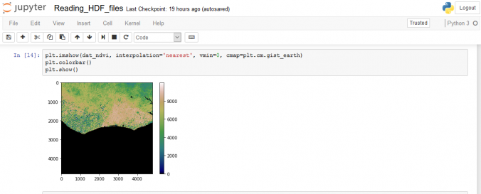
| Description: | Python is a programming language with useful packages, also related to GIS and remote sensing. Several data types, including satellite data, can be processed and analyzed. Anaconda Python is a downloadable distribution including python and several packages for computing (NumPy, SciPy), for visualisation (Matplotlib, Bokeh) and useful IDEs (Jupyter Notebook, Spyder). |
| Software type: | Crowdsourcing/VGI |
| Accessibility: | Install only |
| Requirements: | Install only |
| Computer System: | Windows, MacOSX, Linux |
| Scope: | Image processing, Modelling, Visualisation |
| Vector/Raster: | Vector, Raster |
| Optical data or radar data format: | Optical, Radar |
| Costs: | Free |
| Tutorials: | |

![]()