• English
  • Español
  • Français

United
Nations


Office for Outer Space Affairs
UN-SPIDER Knowledge Portal

  • Home
  • About Us
    • What is UN-SPIDER?
    • About UNOOSA
    • Publications
    • Jobs
    • Meet the Team
    • Contact
  • Space Application
    • Satellite Technology
    • Emergency Mechanisms
    • Recovery Mechanisms
    • International Asteroid Warning Network
    • Space Mission Planning Advisory Group
    • International Space Weather Initiative
    • Space Technologies in the UN
    • User Stories
  • Links & Resources
    • Data Applications
      • Disaster Recovery
    • Data Sources
    • GIS and Remote Sensing Software
    • Online Learning Resources
    • Institutions
  • Risks & Disasters
    • Disaster Risk Management
    • Early Warning Systems
    • Emergency and Disaster Management
    • Natural Hazards
    • Sendai Framework
    • The UN and Disaster Risk Management
    • The UN and Early Warning
    • The UN and Disaster Management
  • Advisory Support
    • Advisory Missions
    • Emergency Support
    • Virtual Advisory Support
    • Recommended Practices
    • Training Activities
    • Practical Uses
  • Network
    • Regional Support Offices
    • GP-STAR
    • MHEWS
    • IWG-SEM
  • Projects
    • SPEAR
    • SEWS-D
    • EvIDENz
    • Flood GUIDE
  • News & Events
    • News
    • Events Calendar
    • UN-SPIDER Events Archive

Breadcrumb

  • Home
  • News and Events
  • View Active News
  • Satellites Show Effects of Long-term Drought On The Congo Rainforest
  • Satellites show effects of long-term drought on the Congo rainforest

Satellites show effects of long-term drought on the Congo rainforest

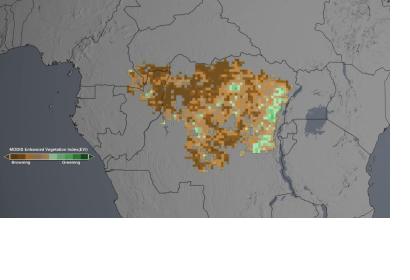
The studies analyzed the "greenness" of the Congo rainforestThe studies analyzed the "greenness" of the Congo rainforest through the Enhanced Vegetation Index.

A new analysis of data derived from various satellite sensors shows that Congo's rainforest, the second-largest tropical rainforest in the world, has suffered from long-term drought over the past ten years. The study included data from the Moderate Resolution Imaging Spectroradiometer (MODIS) instrument on NASA's Terra satellite, the NASA/JAXA Tropical Rainfall Measuring Mission, NASA's Quick Scatterometer (QuikScat), and NASA's Gravity Recovery and Climate Experiment, a joint mission with the German Aerospace Center. It revealed a large-scale decline in greenness of the analyzed areas by calculating the "Enhanced Vegetation Index".

NASA elaborates on their website: "Scientists use the satellite-derived "greenness" of forest regions as one indicator of a forest's health. While this study looks specifically at the impact of a persistent drought in the Congo region since 2000, researchers say that a continued drying trend might alter the composition and structure of the Congo rainforest, affecting its biodiversity and carbon storage."

Lead researcher Liming Zhou of University at Albany, State University of New York said: "It's important to understand these changes because most climate models predict tropical forests may be under stress due to increasing severe water shortages in a warmer and drier 21st century climate."
NASA
Tue, 29 Apr 2014 - 10:04
Congo

Footer menu

  • Contact
  • Terms of Use

User account menu

  • Log in