UN-SPIDER's Regional Support Office in Germany - The Center for Remote Sensing for Land Surfaces (ZFL) – has provided a new practical use case demonstrating the effective utilization of the Copernicus Global Flood Awareness System (GloFAS) for early warning of riverine flood events. This case study, focusing on the devastating floods that occurred in Nigeria in 2022 along the Benue and Niger rivers, showcases the application of GloFAS tools within the disaster management cycle.
Context
In many regions globally, early warning capacities for natural disasters such as floods are limited. Copernicus, as part of the European Union Space Programme, addresses this gap by offering free tools and services to enhance early warning capabilities worldwide. GloFAS, a key component of Copernicus Emergency Management Service’s “Early Warning & Monitoring” portfolio, provides operational flood forecasts with up to a 30-day lead time for major river basins across the globe.
Objective
The primary objective of this case study is to demonstrate how various products available within the GloFAS platform can be effectively utilized in the disaster management cycle, with a focus on flood preparedness.
Application of GloFAS
The case study illustrates the practical application of GloFAS through various tools and features:
- Map Viewer: Utilizing an interactive map viewer to display temporal datasets related to flood risk layers, hydro- and meteorological conditions, and monitoring layers.
- Flood Summary: Interpretation of flood summary layers indicating exceedance probabilities of different return periods, aiding in understanding the potential magnitude of a flood event.
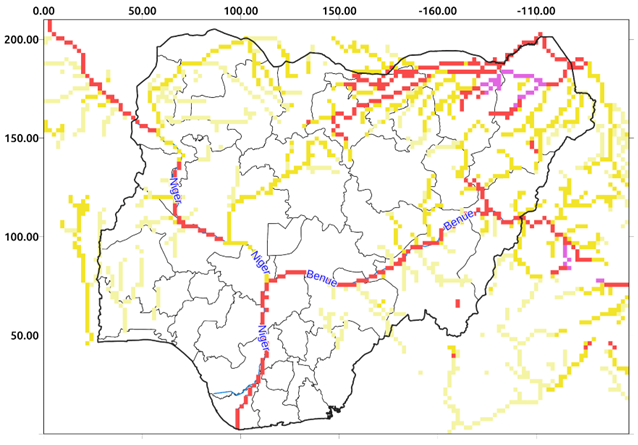
- Reporting Points: Analysis of reporting points along rivers to deduce information about river discharge and flood situations.
- Flood Extent Estimation: Estimation of flood extent based on GloFAS streamflow forecasts, aiding in rapid flood mapping and impact assessment.
- Rapid Impact Assessment: Evaluation of the anticipated impact of floods on administrative units, providing insights for response planning and resource allocation.
Conclusion
The use of GloFAS in the Nigeria flood case study highlights its significance in flood management, particularly in forecasting, warning, and response planning. By leveraging hydrological models and satellite data, GloFAS can provide valuable early warning information, enabling stakeholders to mitigate the impacts of flood disasters effectively.
This practical use case underscores the importance of accessible and reliable early warning systems in disaster management and emphasizes GloFAS's role as a valuable tool in building resilient and adaptive communities.
Find further information, details, and a step-by-step explanation on the page of the Practical Use Case.