• English
  • Español
  • Français

United
Nations


Office for Outer Space Affairs
UN-SPIDER Knowledge Portal

  • Home
  • About Us
    • What is UN-SPIDER?
    • About UNOOSA
    • Publications
    • Jobs
    • Meet the Team
    • Contact
  • Space Application
    • Satellite Technology
    • Emergency Mechanisms
    • Recovery Mechanisms
    • International Asteroid Warning Network
    • Space Mission Planning Advisory Group
    • International Space Weather Initiative
    • Space Technologies in the UN
    • User Stories
  • Links & Resources
    • Data Applications
      • Disaster Recovery
    • Data Sources
    • GIS and Remote Sensing Software
    • Online Learning Resources
    • Institutions
  • Risks & Disasters
    • Disaster Risk Management
    • Early Warning Systems
    • Emergency and Disaster Management
    • Natural Hazards
    • Sendai Framework
    • The UN and Disaster Risk Management
    • The UN and Early Warning
    • The UN and Disaster Management
  • Advisory Support
    • Advisory Missions
    • Emergency Support
    • Virtual Advisory Support
    • Recommended Practices
    • Training Activities
    • Practical Uses
  • Network
    • Regional Support Offices
    • GP-STAR
    • MHEWS
    • IWG-SEM
  • Projects
    • SPEAR
    • SEWS-D
    • EvIDENz
    • Flood GUIDE
  • News & Events
    • News
    • Events Calendar
    • UN-SPIDER Events Archive

Breadcrumb

  • Home
  • News and Events
  • View Active News
  • MODIS: Detecting Managed Bush Fires In Australia
  • MODIS: Detecting managed bush fires in Australia

MODIS: Detecting managed bush fires in Australia

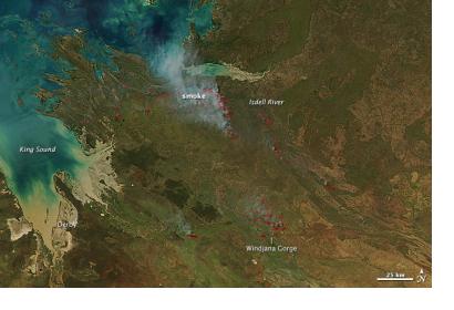
MODIS acquired this image of dozens of managed firesMODIS acquired this image of dozens of managed fires

NASA's Aqua satellite with its Moderate Resolution Imaging Spectroradiometer (MODIS) has acquired an image in Kimberly region on 10 April 2013, Australia showing dozens of managed fires. All of the fires were south and west of the Isdell River; some were burning in and near Windjana Gorge National Park, a popular tourist destination. MODIS detected the fires by thermal infrared energy radiating from the land surface. The locations where MODIS detected fire are labeled with red outlines.

Interestingly, the burns visible in this image are part of the Ecofire program managed by the Australian government and by conservation groups. The goal of the program is to reduce destructive late-season fires by increasing the number of early-season fires. Early-season fires are less dangerous as in the beginning of the dry season in April and May, vegetation has dried enough to burn it is still wet enough that fires won’t grow out of control. Because the early fires tend to burn in a patchwork pattern it becomes easier for vegetation to reestablish itself afterwards. Late-season fires, in contrast, often sweep across the landscape and leave expansive burn scars that alter ecosystems for years.
NASA
Fri, 12 Apr 2013 - 11:53

Footer menu

  • Contact
  • Terms of Use

User account menu

  • Log in