Subsidence refers to the sinking of the ground due to groundwater removal, mining, dissolution of limestone (e.g. karst, sinkholes), extraction of natural gas, and earthquakes. (IRDR)
UN-SPIDER Regional Support Offices with hazard-specific expertise
Subsidence processes, sinkholes, or landslides can cause many problems. Even minor subsidence can weaken buildings and infrastructure and lead to issues such as flooding, and in worst cases abrupt disappearance of sections of land. Monitoring and predicting such processes are essential for adopting mitigating strategies.
The new European Ground Motion Service, created and offered by the Copernicus Land Monitoring Service and implemented by the European Environment Agency, provides free and accessible ground motion data.
Based on radar data from Copernicus Sentinel-1 satellite mission, the service provides information on the motion of land, structures and infrastructure in Copernicus Participating States. Its aim is to give users reliable information on ground motion at a local, regional or national scale.
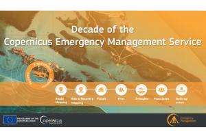
Implementing science to save lives: A Decade of the Copernicus Emergency Management Service
The Copernicus Emergency Management Service (CEMS) celebrates a decade of operation as a world leader in emergency mapping, early warning tools and open-access disaster information.
For the past ten years, CEMS has provided a global service as a fully operation emergency mapping service at no cost to users and with open access data.
Some highlights on the contribution of CEMS in global disaster risk management activities:
576 Rapid Mapping Activations with 5,500+ maps delivered
Designed and implemented the world’s first Global Flood Monitoring tool
Ten years of wildfire forecasts up to ten days into the future
Average of 200+ flood and 500+ flash flood notifications to Member States and authorised users each year
Offers a current and historical database of 7,000+ drought episodes since 1950
The United Nations Office for Outer Space Affairs (UNOOSA) and the National Aeronautics and Space Administration of the United States Government (NASA) signed a landmark Memorandum of Understanding (MoU) on 17 December 2020 pledging cooperation in areas of science and technology to support the peaceful uses of outer space.
The MoU brings together NASA's wealth of open-source spacecraft data, tools, and expertise and UNOOSA's unique position as the only UN entity dedicated to outer space affairs, to expand global opportunities to leverage the benefits of space. The partners will design capacity-building programmes, particularly for institutions in countries that do not yet have or that are developing space capabilities, to help them access space.
Together, UNOOSA and NASA will develop ways to leverage the Artemis programme as part of UNOOSA's Access to Space 4 All Initiative, which offers opportunities for international researchers and institutions, especially in…
According to the latest issue of an annual disaster statistics report, floods were the deadliest type of disasters in 2019, followed by extreme temperature, while storms affected the highest number of people. Published by the Centre for Research on the Epidemiology of Disasters (CRED), “Natural disasters 2019 - Now is the time to not give up” draws on data recorded in the Emergency Events Database (EM-DAT), which saw the addition of 396 disasters that affected a total of 95 million and caused $103 billion in economic losses around the world.
Accounting for 40 per cent of disaster events, Asia suffered the highest impact with 45 per cent of deaths and 74 per cent of total affected. India, which saw cyclone Fani cause destruction in 2019, was the country most…
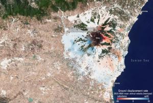
The lowering or sinking of the ground’s surface, referred to as land subsidence, can cause serious damage to infrastructure and private property, and in turn, have an adverse impact on communities, individuals, and the economy. The European Space Agency’s (ESA) Sentinel-1 satellite, part of the Copernicus programme, is being used to monitor cases of land subsidence and contribute to risk assessment and urban development efforts.
From Sentinel-1 radar data collected over time, ground deformation maps can be created, which provide important insights to local authorities charged with implementing hazard mitigation and management strategies. For example, such maps recently helped authorities in…
. Image: Copernicus data (2014)/ESA/DLR Microwave and Radar Institute–SEOM InSARap study.")