![]()
United
Nations
Flood
, processed by ESA, CC BY-SA 3.0 IGO.")
Definition
Facts and figures
Further information
UN-SPIDER Regional Support Offices with hazard-specific expertise
Related content on the Knowledge Portal
 read more
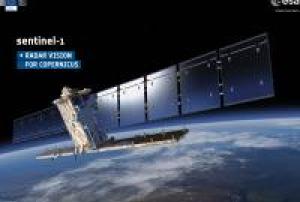
Sentinel-1 is a two satellite constellation with the prime objectives of land and ocean monitoring. The goal of the mission is to provide C-Band Synthetic Aperture Radar (SAR) data continuity following the retirement of ERS-2 and the end of the Envisat mission.
To accomplish this the satellites carry a C-SAR sensor, which offers medium and high resolution imaging in all weather conditiions. The C-SAR is capable of obtaining night imagery and detecting small movement on the ground, which makes it useful for land and sea monitoring.
Sentinel-1 works in a pre-programmed operation mode to avoid conflicts and to produce a consistent long-term data archive built for applications based on long time series.
The mission benefits numerous services. For example, services that relate to the monitoring of Arctic sea-ice extent, routine sea-ice mapping, surveillance of the marine environment, including oil-spill monitoring and ship detection for maritime security, monitoring land-…05/12/2024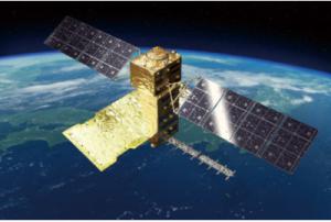
The Advanced Land Observing Satellite-4 (ALOS-4) is a satellite to observe the Earth's surface using its onboard phased array type L-band synthetic aperture radar (PALSAR-3). The L-band radar technology has continuously been developed in Japan. With further improved observation performance compared to the predecessor PALSAR-2 aboard the DAICHI-2 (ALOS-2), JAXA and its prime contractor, Mitsubishi Electric Corporation, are developing the satellite aiming at achieving both high resolution and a broader observation swath.
read more
Unlike observations by an optical sensor, radar images can be acquired day and night as it does not require sunlight. Moreover, since radio waves can penetrate cloud, the images can be obtained regardless of weather condition. The ALOS-4 will leverage these merits for observing and monitoring disaster-hit areas, forests, and sea ice. In addition, it will also challenge new areas such as monitoring infrastructure displacement.
The ALOS-4 will be equipped…01/07/2024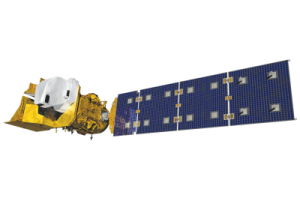
Landsat 9 was successfully launched on Monday, Sept. 27, 2021 from Vandenberg Space Force Base in California. Landsat 9 data is publicly available from USGS.
Landsat 9—a partnership between NASA and the U.S. Geological Survey— continues the Landsat program’s critical role in monitoring, understanding and managing the land resources needed to sustain human life.
Today’s increased rates of global land cover and land use change have profound consequences for weather and climate change, ecosystem function and services, carbon cycling and sequestration, resource management, the national and global economy, human health, and society.
Landsat is the only U.S. satellite system designed and operated to repeatedly observe the global land surface at a moderate scale that shows both natural and human-induced change.
Since reducing the risk of a Landsat data gap is a high priority of the U.S. Sustainable Land Imaging Program, Landsat 9 has a design very similar…
read more27/09/2021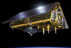 read more
The Sentinel-6 Michael Freilich satellite was launched into orbit on November 21, 2020. The launch was a culminated European-American effort that involved organisations from both sides of the atlantic. The European Space Agency (ESA), the European Organisation for the Exploitation of Meterological Satellites (EUMETSAT), the National Aeronautics and Space Administration (NASA), the National Oceanic and Atmospheric Administration (NOAA) and the National Centre for Space Studes (CNES) all collaborated together to make the launch of Sentinel-6 Michael Freilich a reality. The Sentinel-6 Michael Freilich satellite is the first of the Sentinel-6 satellites. An identical satellite, Sentinel-6B will follow in 2025. At an altitude of 1336 km the Sentinel-6 Michael Freilich satellite will use instruments on board to provide highly accurate measurements of the sea level in an effort to combat…
21/11/2020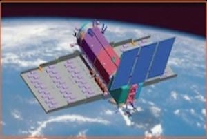
The Argentinean Microwaves Observation Satellite 1B (SAOCOM 1B) was launched into orbit on August 30, 2020 from Space Launch Complex 40 at Cape Canaveral Air Force Station in Florida, United States of America. Developed by the National Argentinean Space Commission (CONAE) in corporation with the Italian Space Agency (ASI), this new satellite joined SAOCOM 1A and four Italian COSMO-SkyMed to complete the Italian-Argentinean Satellite System for Emergency Management (SIASGE). The SAOCOM 1B satellite orbits at 620 km above the earth's surface and is fitted with a Synthetic Aperture Radar (SAR) sensor that makes use of microwaves in the electromagnetic L-band. The spatial resolution of its imagery ranges between 10 and 100 meters. The data collected by SAOCOM 1B helps monitor climatological disasters (forest fires, glacial lake outbursts, droughts) and hydrological disasters (landslides and floods).
30/08/2020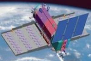
The Argentinean Microwaves Observation Satellite 1B (SAOCOM 1B) was launched into orbit on August 30, 2020 from Space Launch Complex 40 at Cape Canaveral Air Force Station in Florida, United States of America. Developed by the National Argentinean Space Commission (CONAE) in corporation with the Italian Space Agency (ASI), this new satellite joined SAOCOM 1A and four Italian COSMO-SkyMed to complete the Italian-Argentinean Satellite System for Emergency Management (SIASGE). The SAOCOM 1B satellite orbits at 620 km above the earth's surface and is fitted with a Synthetic…
read more30/08/2020
Cartosat-3 satellite is a third generation agile advanced satellite having high resolution imaging capability. Cartosat-3 will address the increased user’s demands for large scale urban planning, rural resource and infrastructure development, coastal land use and land cover etc.
27/11/2019
Comprised of three identical Earth observation satellites working together, Canada's RADARSAT Constellation Mission (RCM) provides daily information about the condition of the Earth's surface. Launched on 12 June 2019, the satellites build upon a legacy of Canadian RADARSAT satellites that spans over twenty years. The RCM will ensure that this data remains available to Canadians, and will provide information to assist in areas such as maritime surveillance, disaster management, and ecosystem monitoring. In terms of maritime surveillance, information collected by the RCM contributes to ice, surface wind, oil pollution, and ship monitoring. RCM information can aid disaster management efforts in terms of mitigation, warning, recovery, and response, and can allow for detailed ecosystem monitoring including in the areas of agriculture, wildlife habitat, wetlands, forestry, and coastal change. The constellation's use of Synthetic Aperture Radar (SAR) allows data to be collected day…
read more12/06/2019Constellation of multiple satellites
03/12/2018
MetOp-C is the third and last satellite of the MetOp series that forms the space segment of the EUMETSAT Polar System (EPS).
read more
MetOp (Meteorological Operational) is Europe's first polar-orbiting operational meteorological satellite. It is the European contribution to the Initial Joint Polar System (IJPS), a co-operative agreement between Eumetsat and the US National Oceanic and Atmospheric Administration (NOAA) to provide data for climate and environmental monitoring and improved weather forecasting.
MetOp-A (launched on 19 October 2006), MetOp-B (launched on 17 September 2012) and MetOp-C (launched 7 November 2018) are in a lower polar orbit, at an altitude of 817 kilometres, to provide more detailed observations of the global atmosphere, oceans and continents. The three satellites will operate in unison for as long as Metop-A's available capacities bring benefits to users. NOAA still continues to operate its mid-afternoon orbit satellite service as part of the…07/11/2018
UN-SPIDER Regional Support Offices with hazard-specific expertise
![]()