![]()
United
Nations
Office for Outer Space Affairs
UN-SPIDER Knowledge Portal
The objective of this practice is to carry out flood hazard assessment, identify the potential flood prone areas and potentially affected infrastructure namely roads, settlements, agriculture and in-land areas etc. against flood hazard of particular return period i.e. 2, 5, 10, 25, 50 and 100 years.
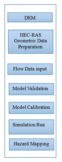
This Recommended Practices uses the HEC-RAS 2D flood model. The model was developed by US Army Corp of Engineer’s Hydrological Engineering Center (HEC). The model can solve 1D and 2D flood hazard problems through 1D, 2D and 1D/2D coupling approaches.
HEC-RAS 2D requires following geometric datasets:
The insights obtained through this Recommended Practice can be used by disaster management agencies and other stakeholders to plan flood rescue, relief and mitigation activities.
Neither UN-SPIDER nor the Regional Support Offices (RSOs) or their partners take any responsibility for the correctness of outputs from this recommended practice or decisions derived as a consequence.
![]()