 |
 |
 |
 |
The duration and intensity of droughts have generally increased in several regions of the world. Agriculture is especially affected, triggering direct consequences on food security, health, and the economic situation of a country. In the recent years, South Africa and Ukraine have severely experienced agricultural droughts which has a direct impact on people and economy respectively. Considering South Africa and Ukraine as pilot countries, the project Earth Observation Based Information Products for Drought Risk Reduction at the National Level (EvIDENz) develops new Earth-Observation-based methods to monitor agricultural drought impacts in both countries.
The project consortium has developed workflows which can be used to contribute to the monitoring of the implementation of the Sendai Framework for Disaster Risk Reduction 2015-2030. Therefore, the workflows have been developed in accordance with the Technical Guidance for Monitoring and Reporting on Progress in Achieving the Global Targets of the Sendai Framework for Disaster Risk Reduction. The aim is to raise awareness regarding the use of space-based technology for monitoring progress in disaster risk management as recommended in the UNDRR Technical Guidance. These workflows will be given global visibility and will be promoted through the recommended practices included in the UNOOSA /UN-SPIDER Knowledge Portal.
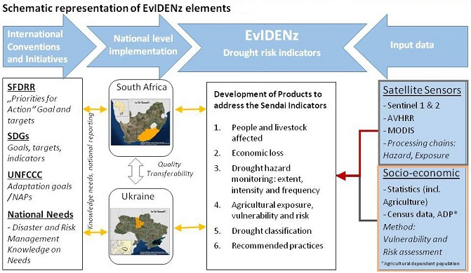
The workflow developed by the Centre for Remote Sensing of Land Surfaces (ZFL) of the University of Bonn and by the United Nations University Institute for Environment and Human Security (UNU-EHS) as part of the EvIDENz project aims to contribute to the estimation of:
- The number of people engaged in agricultural activities that are affected by droughts; Such an estimation will contribute to assess the effectiveness of efforts conducted by countries such as South Africa to achieve Target B of the Technical Guidance for Monitoring and Reporting on Progress in Achieving the Global Targets of the Sendai Framework for Disaster Risk Reduction (Substantially reduce the number of affected people globally by 2030, aiming to lower the average global figure per 100,000 between 2020-2030 compared with 2005-2015)
- The direct economic loss attributed to disasters in relation to global gross domestic product (direct crop loss); this estimate aimed to measure the achievements due to efforts conducted in Ukraine to achieve Target C of the Technical Guidance for Monitoring and Reporting on Progress in Achieving the Global Targets of the Sendai Framework for Disaster Risk Reduction(Reduce direct disaster economic loss in relation to global gross domestic product (GDP) by 2030)
The first segment of the workflow has been developed by the Centre for Remote Sensing of the Land Surfaces (ZFL) using a weighted drought hazard classification based on a set of remote sensing indicators. This segment is based on the Vegetation Condition Index taking into consideration the drought timing such as; the start, end and peak of the season which are the vulnerable growing stages of crop development. This assessment is based on an analysis of the Vegetation Condition Index, phenological metrics and then employs a weighted linear combination (WLC) of the both.
The second segment of the workflow has been developed by UNU-EHS and builds on the drought hazard classification with the assessment of exposed elements for a quantitative measure of the Sendai indicator B-5 (The number of people whose livelihoods were disrupted or destroyed, attributed to agricultural drought) for the Republic South Africa, and the indicator C2c (direct crop loss) for Ukraine. To generate estimates on the economic value of crops directly loss due to a specific disaster and the number of people affected by a disaster, this part of the workflow makes use of the in-situ data generated by the agricultural community and in particular the social-economic data provided by the ministry of agriculture and national authorities.