The VIII Regional Platform for Disaster Risk Reduction in the Americas and the Caribbean (RP23) has successfully concluded in Punta del Este, Uruguay. The event was held in a hybrid format from February 28 to March 2, 2023, under the theme, “Science and Technology for Integrated Disaster Risk Management”. The Government of Uruguay hosted the forum, which aimed to bring together a wide range of stakeholders to discuss and address the issue of disaster risk reduction.
This is event is available for participation on an ongoing basis
The United Nations World Data Forum (UNWDF), which will be held in Hangzhou, China from 24 to 27 April 2023, is inviting Member States, civil society, the private sector, UN agencies, and other organizations to showcase their good practices and success around the four themes of the Forum.
With over 100 events, 70 parallel sessions, 30 learning labs, and exhibits, the Forum will bring together experts and stakeholders from around the world to discuss and exchange ideas on the latest trends, challenges, and opportunities related to global data.
Zambia is a drought-prone country that experiences droughts every 4 to 5 years. This frequency is projected to increase due to climate change. The inadequate infrastructure together with the rural and poor population makes the country highly vulnerable to droughts.
Southern and Central provinces in Zambia are underwater after long-term rainfall starting 11 January, causing overflowing rivers. The floods, reported as “catastrophic” by Zambia’s Disaster Management and Mitigation Unit, have caused widespread damage to homes, farmland, and livestock. The floods have also left numerous communities isolated and sanitation facilities completely submerged, exposing the population to a high risk of waterborne diseases.
UN-SPIDER/DLR/GLOFAS/ZFL Workshop On Space Technologies for Flood Management
The United Nations Platform for Space-based Information for Disaster Management and Emergency Response (UN-SPIDER) in collaboration with the German Aerospace Centre (DLR), the Global Flood Awareness System (GLOFAS) of the Copernicus Programme of the European Commission, and the University of Bonn’s Centre for Remote Sensing of Land Surfaces (ZFL), conducted an international training workshop on space-based technologies for flood management. The workshop was held at the UN Bonn Campus on 20-22 February 2023.
This is event is available for participation on an ongoing basis
Geospatial technologies and remote sensing are valuable resources to monitor the United Nation's Sustainable Development Goals (SDGs) and their corresponding targets and indicators. They allow for unbiased observation and analysis across borders, administrative boundaries, and nations. Furthermore, geospatial information and technologies are particularly critical to strengthening urban and rural resilience, where economic, agricultural, and various social sectors intersect.
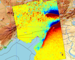
Satellite Data Aids Emergency Response and Recovery Efforts Following Earthquakes in Turkey and Syria
Turkey and Syria recently experienced two devastating earthquakes of magnitude 7.8 and closely followed by a magnitude 7.5, resulting in extensive damage and destruction. The International Charter 'Space and Major Disasters' was activated by Turkish authorities, the United Nations, and the International Federation Red Cross & Red Crescent Societies in response to the earthquakes. The Charter provided more than 350 crisis images from 17 space agencies worldwide, which were used to create damage and situation maps to estimate the hazard impact and support relief actions.
UNDRR published a report detailing the main findings and recommendations of the midterm review of the implementation of the Sendai Framework for Disaster Risk Reduction 2015-2030. The report provides valuable insights into the progress made towards achieving the Sendai Framework's goals and identifies key areas for action moving forward. The findings and recommendations are likely to be of interest to policymakers, disaster risk management practitioners, and others working in the field of disaster risk reduction.
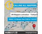
UN Mappers Activation - Mapathon to support Turkey
UN Mappers calls all mappers to support the Turkish Open Street Map community following the earthquake that hit southern Turkey and northern Syria on Monday 6 February.
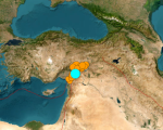
Earthquake in Turkey and Syria - International Charter and Copernicus active
A major earthquake of magnitude 7.8 struck Turkey with epicentre on 23 kilometres east of Nurdagi (Gaziantep Province) on February 6, 2023. By the activity spreading to adjacent faults, the region was hit by a 6.7- magnitude and a 7.5- magnitude aftershocks respectively. The earthquake also affected neighbouring Syria.