Application of NASA SPoRT-Land Information System (SPoRT-LIS) Soil Moisture Data for Drought

This is event is available for participation on an ongoing basis

This training is focused on the introduction of the NASA Land Information System (LIS) output of soil moisture at various depths for drought analysis and monitoring. As a result of the NASA Short-term Prediction Research and Transition Center (SPoRT) program and its research-to-operations (R2O) work, this training will demonstrate how LIS output of soil moisture from a land surface model (LSM) can be included in traditional drought monitoring applications.

0
0
No certificate issued or not known
0.00
USD
05/17/2023, 12:00am - 05/31/2023, 12:00am
not visible
1

NOAA Upgrades Model to Improve Storm Surge Forecasting

The National Oceanic and Atmospheric Administration (NOAA) has recently upgraded its Probabilistic Storm Surge (P-Surge) model ahead of 2023 Hurricane Season beginning on June 1. The P-Surge is the primary model for predicting storm surge associated with high-impact weather, such as hurricanes and tropical storms. The version 3.0 advances storm surge modeling and forecasting for the continental United States, Puerto Rico, and the Virgin Islands.

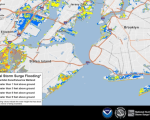
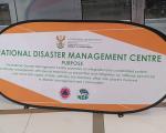
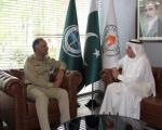
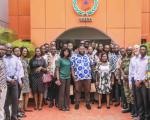
UN-SPIDER’s Institutional Strengthening Mission to South Africa

As part of its efforts to provide advisory support to national disaster management agencies and other stakeholders in Africa, UN-SPIDER is carrying out an Institutional Strengthening Mission to South Africa from 8 to 12 May 2023.

martin.hilljegerdes Wed, 10 May 2023 - 09:27

Pakistan and Kuwait to Collaborate in Disaster Mitigation and Utilizing Satellite Technology

The Ambassador of Kuwait to Pakistan recently met with the Chairman of the National Disaster Management Authority (NDMA) to discuss potential strategies for participative investment in pre-disaster planning and management.

66th Session of the Committee on the Peaceful Uses of Outer Space (COPUOS): 2023

This is event is available for participation on an ongoing basis

The Committee on the Peaceful Uses of Outer Space (COPUOS) was set up by the General Assembly in 1959 to govern the exploration and use of space for the benefit of all humanity: for peace, security and development. The Committee was tasked with reviewing international cooperation in peaceful uses of outer space, studying space-related activities that could be undertaken by the United Nations, encouraging space research programmes, and studying legal problems arising from the exploration of outer space.

0
0
No certificate issued or not known
0.00
USD
05/31/2023, 12:00am - 06/09/2023, 12:00am
Visible
Vienna

Ghana's pledge of a new National Disaster Preparedness Baseline Assessment

Ghana's National Disaster Management Organization (NADMO) is undertaking a new National Disaster Preparedness Baseline Assessment in collaboration with the University of Hawaii's Pacific Disaster Center (PDC). This new assessment responds to the initiative of further developing Ghana's risk reduction capacity concerning multiple hazards.

WMO publishes State of the Global Climate report for 2022

The World Meteorological Organization (WMO) has launched its "State of the Global Climate 2022" annual report on April 21, 2023. The report focuses on key climate indicators, such as greenhouse gases, sea level rise, temperatures, ocean heat and acidification, sea ice and glaciers, and highlights the impacts of climate change and exteme weather. 

Anticipatory Action in 2022: A Global Overview

The Anticipation Hub has published this week the "Anticipatory Action in 2022: A Global Overview" annual report that captures for the first time the scale of anticipatory action worldwide. The report discusses how the scope of anticipatory action expanded in 2022, in terms of hazards, triggers in place, and anticipatory actions implemented. It also shows how 35 countries implemented anticipatory actions in 2022 and are ready to act ahead of forecast hazards.

Webinar on Remote Sensing for Flood Risk and Hazard Management

This is event is available for participation on an ongoing basis

The Multidisciplinary Digital Publishing Institute (MDPI) is organizing a continuation of the EO&GEO Series with the online webinar "Remote Sensing for Flood Risk and Hazard Management", taking place online on May 11. In this webinar, three internationally recognized experts will present some of the great developments in the areas of hydrology and flood management, discussing recent advances in topography, flood modeling, discharge measurements, and flood disaster mapping.<

0
0
No certificate issued or not known
0.00
USD
05/11/2023, 12:00am
not visible
1