• English
  • Español
  • Français

United
Nations


Office for Outer Space Affairs
UN-SPIDER Knowledge Portal

  • Home
  • About Us
    • What is UN-SPIDER?
    • About UNOOSA
    • Publications
    • Jobs
    • Meet the Team
    • Contact
  • Space Application
    • Satellite Technology
    • Emergency Mechanisms
    • Recovery Mechanisms
    • International Asteroid Warning Network
    • Space Mission Planning Advisory Group
    • International Space Weather Initiative
    • Space Technologies in the UN
    • User Stories
  • Links & Resources
    • Data Applications
      • Disaster Recovery
    • Data Sources
    • GIS and Remote Sensing Software
    • Online Learning Resources
    • Institutions
  • Risks & Disasters
    • Disaster Risk Management
    • Early Warning Systems
    • Emergency and Disaster Management
    • Natural Hazards
    • Sendai Framework
    • The UN and Disaster Risk Management
    • The UN and Early Warning
    • The UN and Disaster Management
  • Advisory Support
    • Advisory Missions
    • Emergency Support
    • Virtual Advisory Support
    • Recommended Practices
    • Training Activities
    • Practical Uses
  • Network
    • Regional Support Offices
    • GP-STAR
    • MHEWS
    • IWG-SEM
  • Projects
    • SPEAR
    • SEWS-D
    • EvIDENz
    • Flood GUIDE
  • News & Events
    • News
    • Events Calendar
    • UN-SPIDER Events Archive

Breadcrumb

  • Home
  • MetOp-B
  • MetOp-B

MetOp-B

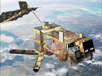
METOP (Meteorological Operational) is Europe's first polar-orbiting operational meteorological satellite. It is the European contribution to the Initial Joint Polar System (IJPS), a co-operative agreement between Eumetsat and the US National Oceanic and Atmospheric Administration (NOAA) to provide data for climate and environmental monitoring and improved weather forecasting.
Metop-A (launched on 19 October 2006), Metop-B (launched on 17 September 2012) and Metop-C (launched 7 November 2018) are in a lower polar orbit, at an altitude of 817 kilometres, to provide more detailed observations of the global atmosphere, oceans and continents. The three satellites will operate in unison for as long as Metop-A's available capacities bring benefits to users. NOAA still continues to operate its mid-afternoon orbit satellite service as part of the Polar Orbit Enviromental Satellites (POES) system.

Instruments:
A/DCS (Advanced Data Collection System)
AMSU (Advanced Microwave Sounding Unit)
ASCAT (Advanced Scatterometer)
AVHRR/3 (Advanced Very High Resolution Radiometer)
GOME-2 (Global Ozone Monitoring Experiment-2)
GRAS (GNSS Receiver for Atmospheric Sounding)
HIRS/4 (High Resolution Infrared Sounder)
IASI (Infrared Atmospheric Sounding Interferometer)
MHS (Microwave Humidty Sounder)
SARP/3 (Search And Rescue Processor)
SARR (Search And Rescue Repeater)
SEM-2 (Space Environmental Monitor)
17 Sep 2012
15years
Low Earth
Sun synchronous
101 minutes
Advanced Microwave Sounding Unit - A
Advanced Microwave Sounding Unit - B
Global Ozone Monitoring Experiment-2
GOME -2
Microwave Humidity Sounder
NOAA
EUMETSAT
ESA
CNES
Providing weather data services to monitor the climate and improve weather forecasts
Drought
Extreme Temperature
Flood
Severe Storm
No
Information about MetOp-A on ESA web page

Footer menu

  • Contact
  • Terms of Use

User account menu

  • Log in