
The oil slick creeping toward Iran's Hara wetlands shows why remote sensing is no longer optional in conflict zones
As the conflict continues in the Persian Gulf, satellite imagery is helping to reveal an unfolding environmental disaster and highlighting the importance of systematic remote monitoring of environmental impacts.
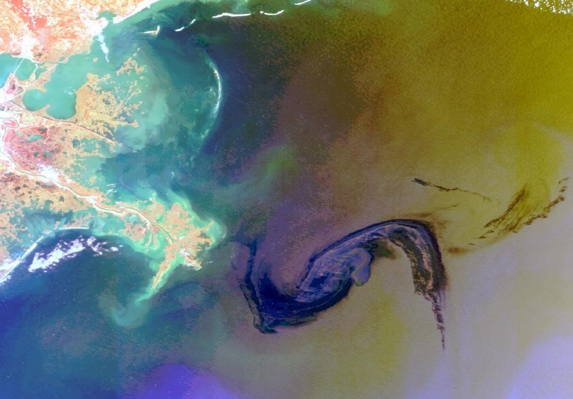
A slow-moving environmental crisis is unfolding in one of the Persian Gulf's most ecologically vital corners. The Shahid Bagheri, an Iranian drone carrier struck by US warplanes in early March, has been leaking heavy fuel oil into the narrow Khuran strait near the island of Qeshm. Satellite image analysis suggests the slick has been drifting steadily toward the Hara biosphere reserve, the largest mangrove forest on the Persian Gulf shoreline, and a critical habitat for migrating birds, endangered turtles, and the fishing communities that depend on the sea for their livelihoods. Analysts tracking the spill warn it could become the most ecologically significant in the region since the first Persian Gulf War (The Guardian, 2026).
Environmental analysts warn the cumulative risk is severe: the Persian Gulf's enclosed, ecologically sensitive waters have little margin for error when warships and tankers become targets.

What satellites can (and cannot) see
What makes this crisis visible at all is satellite remote sensing. From hundreds of kilometers above, satellites are tracking the oil's slow westward progress day by day, giving analysts and conservation groups data they could not otherwise obtain from areas with restricted or limited ground access. This highlights the type of scenario where space-based information can be particularly valuable.
Environmental damage such as oil spills is among the hazard events that become visible from space almost immediately, making them particularly well-suited to satellite-based monitoring. Yet the broader challenge is one of access, scale, and political economy. Very-high resolution (VHR) satellite imagery, defined as imagery with a ground resolution below five meters, is increasingly used to visualize the effects of armed conflicts in near-real time, but these data are typically commercial and generally released selectively or for a fee, which can limit accessibility for scientific and humanitarian applications (Bennett et al., 2022).
Researchers have called for three concrete steps to address this: archiving VHR images for scientific and humanitarian use; producing analysis-ready, conflict-wide mosaics that extend beyond urban centers to harmonize monitoring; and forming a sustainably funded public VHR satellite program that could transform these data into a genuine global public good. A multilateral effort inspired by the European Space Agency's Copernicus and Sentinel programs, perhaps involving NASA, ESA, and other national space agencies, could help ensure that satellite imagery of conflicts is available worldwide, rather than primarily provided by commercial operators, often influenced by national regulations and priorities (ibid.).
Freely available imagery: Environmental monitoring in complex emergency contexts
The good news is that freely available, moderate-resolution imagery from programs like the ESA's Sentinel constellations is increasingly capable of supporting environmental monitoring and impact assessment in complex contexts. While much research focus has been on high spatial resolution imagery, freely available satellite images with moderate spatial but high temporal resolution, reviewed at regular intervals rather than tasked on demand, can lead to more scalable and transferable monitoring options. Progress in deep learning is making change detection at the sub-pixel level increasingly possible, meaning that algorithms can pick up on subtle environmental changes that even trained human analysts might miss. However, there are also risks to acknowledge. AI-based detection systems only provide likelihood estimates, not certainties. Biases in training data can create biases in what gets flagged and what gets ignored; potentially underreporting hazards, or systematically missing certain types of environmental harm.(Sticher et al., 2023).
Combining optical imagery with synthetic aperture radar (SAR), which can see through clouds and does not depend on daylight, further strengthens the toolkit. SAR sensors actively emit a microwave signal, meaning they can acquire images independently of sunlight, and their sensitivity to subtle surface changes makes them particularly valuable for detecting damage that optical imagery might miss, such as a collapsed structure with an intact roof. The Sentinel-1 and Sentinel-2 constellations, operated by the ESA and freely available to researchers, offer both optical and SAR coverage of the entire globe at regular intervals (ibid.).
What monitoring systems can realistically do
For organizations seeking to monitor environmental damage from conflicts, the most feasible near-term applications are those that provide a general sense of the scope and geographic distribution of harm, rather than requiring human verification of every individual event. Remote monitoring can also serve as an early warning system, particularly for slow-onset environmental crises in areas receiving little international attention. The Hara wetland crisis fits that description almost perfectly: ecologically catastrophic in potential, geographically remote, and unfolding in a conflict zone where no cleanup crews can yet reach.
Researchers and practitioners have called for interdisciplinary collaboration and conflict-sensitive monitoring solutions to ensure that the growing power of remote sensing is harnessed to support humanitarian and environmental objectives. They also highlight the importance of making non-sensitive data available for research purposes, where appropriate, to accelerate the development of better detection models and larger shared datasets (Sticher et al., 2023).
Sources:
- Bennett, M. M., Van Den Hoek, J., Zhao, B., & Prishchepov, A. V. (2022). Improving satellite monitoring of armed conflicts. Earth’s Future, 10(9), e2022EF002904. https://doi.org/10.1029/2022EF002904
- Sticher, V., Wegner, J. D., & Pfeifle, B. (2023). Toward the remote monitoring of armed conflicts. PNAS Nexus, 2(6), pgad181. https://doi.org/10.1093/pnasnexus/pgad181
- The Guardian. (2026, April 7). Oil slick from bombed Iranian ship threatens protected wetland. https://www.theguardian.com/environment/2026/apr/07/oil-slick-shahid-bagheri-iran-ship-hara-wetland