• English
  • Español
  • Français

United
Nations


Office for Outer Space Affairs
UN-SPIDER Knowledge Portal

  • Home
  • About Us
    • What is UN-SPIDER?
    • About UNOOSA
    • Publications
    • Jobs
    • Meet the Team
    • Contact
  • Space Application
    • Satellite Technology
    • Emergency Mechanisms
    • Recovery Mechanisms
    • International Asteroid Warning Network
    • Space Mission Planning Advisory Group
    • International Space Weather Initiative
    • Space Technologies in the UN
    • User Stories
  • Links & Resources
    • Data Applications
      • Disaster Recovery
    • Data Sources
    • GIS and Remote Sensing Software
    • Online Learning Resources
    • Institutions
  • Risks & Disasters
    • Disaster Risk Management
    • Early Warning Systems
    • Emergency and Disaster Management
    • Natural Hazards
    • Sendai Framework
    • The UN and Disaster Risk Management
    • The UN and Early Warning
    • The UN and Disaster Management
  • Advisory Support
    • Advisory Missions
    • Emergency Support
    • Virtual Advisory Support
    • Recommended Practices
    • Training Activities
    • Practical Uses
  • Network
    • Regional Support Offices
    • GP-STAR
    • MHEWS
    • IWG-SEM
  • Projects
    • SPEAR
    • SEWS-D
    • EvIDENz
    • Flood GUIDE
  • News & Events
    • News
    • Events Calendar
    • UN-SPIDER Events Archive

Breadcrumb

  • Home
  • News and Events
  • View Active News
  • UN-SPIDER Highlights Role of Earth Observation In Understanding Exposure of Urban Infrastructure To Hazards At Resilient Infrastructure Forum
  • UN-SPIDER highlights role of Earth observation in understanding exposure of urban infrastructure to hazards at Resilient Infrastructure Forum

UN-SPIDER highlights role of Earth observation in understanding exposure of urban infrastructure to hazards at Resilient Infrastructure Forum

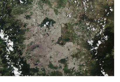
Natural-colour Sentinel-2A image of Mexico City and surroundings. Image: Copernicus Sentinel data (2015)/ESA, CC BY-SA 3.0 IGO.Natural-colour Sentinel-2A image of Mexico City and surroundings. Image: Copernicus Sentinel data (2015)/ESA, CC BY-SA 3.0 IGO.

Under the annual theme "Towards A Safer Urban Future", the 2nd Resilient Infrastructure Forum took place in Colombia from 4 to 6 June 2019. The Forum aimed to develop a coordinated long-term strategy to overcome challenges posed by disasters, such as severe storms, tsunamis or earthquakes in Latin America and the Caribbean. At the event, UN-SPIDER underlined the benefits of space-based information for understanding the exposure of coastal urban infrastructure to natural hazards and highlighted how land-use changes, which can be observed through a combination of space data and aerial photography, lead to more frequent and more intense floods in cities in the region.

By enhancing the capacity of the region's institutions and private sector to plan, design and implement investments in disaster resilient infrastructure, RIF2019 provides a platform for specialists to support various stakeholders, such as governments or regional agencies to develop resilient strategies and to introduce international technology and service providers.

At RIF2019, UN-SPIDER provided inputs on how the combination of information on exposure derived from Earth observation, information on coastal hazards and vulnerability can be used to improve early warning efforts in coastal areas due to tsunamis and storm surges.

Besides, satellite imagery offers information on the physical infrastructure that is exposed to natural hazards. In coastal areas, this is important to assess the potential impact of a tsunami in coastal cities. Information on exposed elements and critical infrastructure allow to identify the location of highly vulnerable groups and places that congregate vast amounts of people (main bus stands, train stations, public markets, shopping areas, etc). Such information can then be used to develop “impact-based forecasts” and to develop warning strategies (who to warn first, for example) and evacuation routes.  

Furthermore, the combination of aerial photography from decades ago and satellite imagery from recent years allows city planners to understand how urban growth is taking place over the decades. In that way, risks and risks drivers can be better understood and mitigated.
 

2nd Resilient Infrastructure Forum Website
Thu, 6 Jun 2019 - 17:29
Latin America and Caribbean

Footer menu

  • Contact
  • Terms of Use

User account menu

  • Log in