• English
  • Español
  • Français

United
Nations


Office for Outer Space Affairs
UN-SPIDER Knowledge Portal

  • Home
  • About Us
    • What is UN-SPIDER?
    • About UNOOSA
    • Publications
    • Jobs
    • Meet the Team
    • Contact
  • Space Application
    • Satellite Technology
    • Emergency Mechanisms
    • Recovery Mechanisms
    • International Asteroid Warning Network
    • Space Mission Planning Advisory Group
    • International Space Weather Initiative
    • Space Technologies in the UN
    • User Stories
  • Links & Resources
    • Data Applications
      • Disaster Recovery
    • Data Sources
    • GIS and Remote Sensing Software
    • Online Learning Resources
    • Institutions
  • Risks & Disasters
    • Disaster Risk Management
    • Early Warning Systems
    • Emergency and Disaster Management
    • Natural Hazards
    • Sendai Framework
    • The UN and Disaster Risk Management
    • The UN and Early Warning
    • The UN and Disaster Management
  • Advisory Support
    • Advisory Missions
    • Emergency Support
    • Virtual Advisory Support
    • Recommended Practices
    • Training Activities
    • Practical Uses
  • Network
    • Regional Support Offices
    • GP-STAR
    • MHEWS
    • IWG-SEM
  • Projects
    • SPEAR
    • SEWS-D
    • EvIDENz
    • Flood GUIDE
  • News & Events
    • News
    • Events Calendar
    • UN-SPIDER Events Archive

Breadcrumb

  • Home
  • News and Events
  • View Active News
  • Satellites Assist Emergency Response After The Tianjin Blasts
  • Satellites assist emergency response after the Tianjin blasts

Satellites assist emergency response after the Tianjin blasts

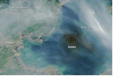
Satellite image of smoke produced by massive explosions in Tianjin (Image: NASA)Satellite image of smoke produced by massive explosions in Tianjin (Image: NASA)

On the morning of August 13 the China Aerospace Science and Technology Corp activated its emergency response mechanism, after the fatal warehouse explosions that hit Tianjin port city. It used at least eight of its satellite constellation to monitor rescue and damage operatins thanks to their clear images.

Specifically, the Gaofen 1 and 2 high-resolution Earth observation satellites, the Ziyuan 3 Earth mapping satellite, the Shijian 9A technology test satellite, the Huanjing 1A low-resolution Earth observation satellite, the CBERS 4 remote sensing satellite, the Fengyun 2G and Fengyun 3B satellites were employed. Additionally, the National Satellite Meteorological Center also mobilized its weather satellites. They captured images in order to detect fires in the blast zones and sent them to government departments in order to carry out damage evaluation and support rescue activities. 

According to an anonymous space expert, "Earth observation satellites have many types of imaging devices, so compared with other observation platforms they are more resistant to bad weather and can obtain high-definition pictures through smoke caused by the blasts."
EARSC
Mon, 24 Aug 2015 - 16:01
China

Footer menu

  • Contact
  • Terms of Use

User account menu

  • Log in