• English
  • Español
  • Français

United
Nations


Office for Outer Space Affairs
UN-SPIDER Knowledge Portal

  • Home
  • About Us
    • What is UN-SPIDER?
    • About UNOOSA
    • Publications
    • Jobs
    • Meet the Team
    • Contact
  • Space Application
    • Satellite Technology
    • Emergency Mechanisms
    • Recovery Mechanisms
    • International Asteroid Warning Network
    • Space Mission Planning Advisory Group
    • International Space Weather Initiative
    • Space Technologies in the UN
    • User Stories
  • Links & Resources
    • Data Applications
      • Disaster Recovery
    • Data Sources
    • GIS and Remote Sensing Software
    • Online Learning Resources
    • Institutions
  • Risks & Disasters
    • Disaster Risk Management
    • Early Warning Systems
    • Emergency and Disaster Management
    • Natural Hazards
    • Sendai Framework
    • The UN and Disaster Risk Management
    • The UN and Early Warning
    • The UN and Disaster Management
  • Advisory Support
    • Advisory Missions
    • Emergency Support
    • Virtual Advisory Support
    • Recommended Practices
    • Training Activities
    • Practical Uses
  • Network
    • Regional Support Offices
    • GP-STAR
    • MHEWS
    • IWG-SEM
  • Projects
    • SPEAR
    • SEWS-D
    • EvIDENz
    • Flood GUIDE
  • News & Events
    • News
    • Events Calendar
    • UN-SPIDER Events Archive

Breadcrumb

  • Home
  • News and Events
  • View Active News
  • NOAA's GOES-T Satellite Launched Successfully
  • NOAA's GOES-T satellite launched successfully

NOAA's GOES-T satellite launched successfully

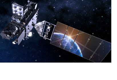
NOAA's GOEST-T Satellite (Image: NOAA)NOAA's GOEST-T Satellite (Image: NOAA)

The National Oceanic & Atmospheric Administration (NOAA) (U.S. Department of Commerce) successfully launched its newest weather satellite GOES-T on 1 March 2022.  

NOAA’s GOES-T is the third satellite in the Geostationary Operational Environmental Satellites (GOES) – R Series, a Western Hemisphere’s weather observing and environmental monitoring system. 

The GOES-R Series provides advanced imagery and atmospheric measurements, real-time mapping of lightning activity, and space weather monitoring. After GOES-T launches, it will be renamed GOES-18 once it reaches geostationary orbit. Following a successful on-orbit checkout of its instruments and systems, NOAA plans to put GOES-T immediately into operational service, replacing GOES-17 as GOES West. GOES-18 will work in tandem with GOES-16, NOAA’s operational GOES East satellite. Together, GOES-16 and GOES-18 will watch over more than half the globe – from the west coast of Africa to New Zealand. GOES-17 will become an on-orbit spare.

The primary instrument on the GOES Series for imaging Earth's weather, oceans and environment is the Advanced Baseline Imager (ABI) and is used for a wide range of applications, among others related to weather, hurricanes and natural hazards.

Image: NOAA's GOEST-T Satellite (Credit: NOAA) https://www.nesdis.noaa.gov/next-generation/goes-t/goes-t-media-resources 
https://www.nesdis.noaa.gov/next-generation/goes-t-launch
Fri, 4 Mar 2022 - 14:24

Footer menu

  • Contact
  • Terms of Use

User account menu

  • Log in