The joint NISAR (NASA–ISRO Synthetic Aperture Radar) mission has captured its first radar images of the Earth’s surface, previewing data that will soon support global monitoring of land, ice, and vegetation. Launched by the Indian Space Research Organisation (ISRO) on July 30, 2025, the satellite was raised to its operational 747-kilometer orbit in mid-September and will survey land and ice twice every 12 days using a 12-meter drum-shaped antenna reflector, the largest NASA has flown.
Radar Capabilities and Applications
The L-band operates at a 25-centimeter wavelength, allowing signals to penetrate forest canopies and measure soil moisture and ground or ice motion down to fractions of an inch. This sensitivity supports tracking land and ice movement before, during, and after earthquakes, volcanic eruptions, and landslides. The images show that the L-band radar can distinguish land cover types, such as low-lying vegetation, trees, and human structures, making it vital for monitoring changes to forest and wetland ecosystems and seasonal crop growth worldwide.
The mission also carries an S-band radar from ISRO’s Space Applications Centre that uses a 10-centimeter wavelength more sensitive to small vegetation, effective for monitoring certain agriculture and grassland ecosystems. NISAR is the first satellite to carry both L- and S-band radars, providing a comprehensive view of Earth’s surface changes. The mission’s radar imagery will provide decision-makers with actionable information to support disaster response and agricultural management.

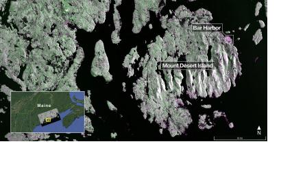
On August 21, 2025, NISAR’s L-band Synthetic Aperture Radar (SAR) system, built by NASA’s Jet Propulsion Laboratory (JPL), imaged Mount Desert Island on the coast of Maine, in which the water appears dark, forests are green, and built-up or bare surfaces are magenta. The radar’s 5-meter resolution revealed narrow waterways and offshore islets. Two days later, NISAR imaged northeastern North Dakota, capturing farmland, wetlands, and forests along the Forest River. The radar distinguished fallow fields and active cropland, with circular patterns indicating center-pivot irrigation, highlighting its potential for agricultural and land-use monitoring.
Mission Collaboration
NISAR is a long-standing NASA–ISRO partnership, promoting space cooperation between the US and India. ISRO provided the S-band SAR, spacecraft bus, launch vehicle, and launch services. Key deployments and operations are executed and monitored by the ISRO Telemetry, Tracking and Command Network’s global ground stations.
NASA’s JPL leads the US contribution, including the L-band SAR, reflector and boom, high-rate science communications subsystem, solid-state data recorder, and payload data subsystem. NASA’s Goddard Space Flight Center manages the Near Space Network, which receives NISAR’s L-band data.
A Global Scientific Milestone
Emphasizing the importance of early observations, Nicky Fox, associate administrator of NASA’s Science Mission Directorate, declared, “These initial images are just a preview of the hard-hitting science that NISAR will produce — data and insights that will enable scientists to study Earth’s changing land and ice surfaces in unprecedented detail while equipping decision-makers to respond to natural disasters and other challenges.”
The preliminary L-band images offer an early glimpse of the detailed observations NISAR will routinely provide once full science operations begin in November. As NISAR transitions to full operations, the mission will deliver a continuous, high-resolution record of Earth’s dynamic surface changes, paving the way to advance global disaster management.

