• English
  • Español
  • Français

United
Nations


Office for Outer Space Affairs
UN-SPIDER Knowledge Portal

  • Home
  • About Us
    • What is UN-SPIDER?
    • About UNOOSA
    • Publications
    • Jobs
    • Meet the Team
    • Contact
  • Space Application
    • Satellite Technology
    • Emergency Mechanisms
    • Recovery Mechanisms
    • International Asteroid Warning Network
    • Space Mission Planning Advisory Group
    • International Space Weather Initiative
    • Space Technologies in the UN
    • User Stories
  • Links & Resources
    • Data Applications
      • Disaster Recovery
    • Data Sources
    • GIS and Remote Sensing Software
    • Online Learning Resources
    • Institutions
  • Risks & Disasters
    • Disaster Risk Management
    • Early Warning Systems
    • Emergency and Disaster Management
    • Natural Hazards
    • Sendai Framework
    • The UN and Disaster Risk Management
    • The UN and Early Warning
    • The UN and Disaster Management
  • Advisory Support
    • Advisory Missions
    • Emergency Support
    • Virtual Advisory Support
    • Recommended Practices
    • Training Activities
    • Practical Uses
  • Network
    • Regional Support Offices
    • GP-STAR
    • MHEWS
    • IWG-SEM
  • Projects
    • SPEAR
    • SEWS-D
    • EvIDENz
    • Flood GUIDE
    • CommonSpace Initiative
  • News & Events
    • News
    • Events Calendar
    • UN-SPIDER Events Archive

Breadcrumb

  • Home
  • News and Events
  • View Active News
  • New Online Resources For Copernicus Marine Environment Monitoring Service
  • New online resources for Copernicus Marine Environment Monitoring Service

New online resources for Copernicus Marine Environment Monitoring Service

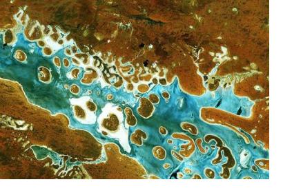
Sentinel-2A captured Lake Amadeus in Australia’s Northern TerritorySentinel-2A captured Lake Amadeus in Australia’s Northern Territory on 19 December 2015. Image: ESA/2015.

The Copernicus Marine Environment Monitoring Service (CMEMS) has published a number of new free online tutorials on how to use the information services provided by it.

35 video tutorials covering a variety of topics from beginner to advanced level have been uploaded and can now be accessed by anyone interested in marine environment monitoring. Among them are videos on a range of satellite products with which it is, for instance, possible to learn more about sea surface temperature observation or ocean colour.

Furthermore, a new series of introductory videos on the Copernicus programme and its services is now available on YouTube. The videos range from providing a general introduction to the programme to explaining in detail how to download a subset of data. Additional information on how to access Copernicus data can also be found here.

The Copernicus Programme aims at developing European information services based on satellite earth observation and non space-based data. It adopts a full,free and open data policy its services address six main thematic areas including the CMEMS:

  • Marine Environment Monitoring
  • Land Monitoring
  • Atmosphere Monitoring
  • Emergency Management
  • Security
  • Climate Change

These services are based on data from the Sentinel satellites, a dedicated constellation of satellites developed to meet the specific needs of the Copernicus programme. The most recent addition to this constellation, the Sentinel-5 Precursor satellite, was launched into space on 13 October and will carry out atmospheric measurements.
New tutorials on the Copernicus Marine Environment Monitoring Service now avail…
Tue, 17 Oct 2017 - 10:16
Europe

Footer menu

  • Contact
  • Terms of Use

User account menu

  • Log in