• English
  • Español
  • Français

United
Nations


Office for Outer Space Affairs
UN-SPIDER Knowledge Portal

  • Home
  • About Us
    • What is UN-SPIDER?
    • About UNOOSA
    • Publications
    • Jobs
    • Meet the Team
    • Contact
  • Space Application
    • Satellite Technology
    • Emergency Mechanisms
    • Recovery Mechanisms
    • International Asteroid Warning Network
    • Space Mission Planning Advisory Group
    • International Space Weather Initiative
    • Space Technologies in the UN
    • User Stories
  • Links & Resources
    • Data Applications
      • Disaster Recovery
    • Data Sources
    • GIS and Remote Sensing Software
    • Online Learning Resources
    • Institutions
  • Risks & Disasters
    • Disaster Risk Management
    • Early Warning Systems
    • Emergency and Disaster Management
    • Natural Hazards
    • Sendai Framework
    • The UN and Disaster Risk Management
    • The UN and Early Warning
    • The UN and Disaster Management
  • Advisory Support
    • Advisory Missions
    • Emergency Support
    • Virtual Advisory Support
    • Recommended Practices
    • Training Activities
    • Practical Uses
  • Network
    • Regional Support Offices
    • GP-STAR
    • MHEWS
    • IWG-SEM
  • Projects
    • SPEAR
    • SEWS-D
    • EvIDENz
    • Flood GUIDE
  • News & Events
    • News
    • Events Calendar
    • UN-SPIDER Events Archive

Breadcrumb

  • Home
  • News and Events
  • View Active News
  • NASA Maps Location and Faults of Iran Earthquakes
  • NASA maps location and faults of Iran earthquakes

NASA maps location and faults of Iran earthquakes

Earthquake and plate tectonics data in Iran

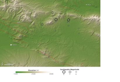
On August 11, 2012 two strong earthquakes shook Iran. The NASA Earth Observatory image shows earthquake locations, magnitudes and faults that are superimposed on a digital elevation map, made from the ASTER Global Digital Elevation Model Version 2 (GDEM2) using earthquake and plate tectonics data from the USGS Earthquake Hazard Program.

The two earthquakes were separated only by 11 minutes and 10 kilometers. The U.S. Geological Survey (USGS) explained that they occurred in the crust of the Eurasian Plate. In this region, the Arabian Plate moves around 26 millimeters per year northward with respect to the Eurasian Plate, but USGS stated that these earthquakes happened about 300 kilometers east of the plate boundary. Probably the events occurred due to an oblique strike-slip fault, where blocks of Earth slide past each other, but because of the location was so far from a plate boundary it is difficult to give accurate explanation.
NASA Earth Observatory
Tue, 14 Aug 2012 - 09:41
Iran (Islamic Republic of)

Footer menu

  • Contact
  • Terms of Use

User account menu

  • Log in