• English
  • Español
  • Français

United
Nations


Office for Outer Space Affairs
UN-SPIDER Knowledge Portal

  • Home
  • About Us
    • What is UN-SPIDER?
    • About UNOOSA
    • Publications
    • Jobs
    • Meet the Team
    • Contact
  • Space Application
    • Satellite Technology
    • Emergency Mechanisms
    • Recovery Mechanisms
    • International Asteroid Warning Network
    • Space Mission Planning Advisory Group
    • International Space Weather Initiative
    • Space Technologies in the UN
    • User Stories
  • Links & Resources
    • Data Applications
      • Disaster Recovery
    • Data Sources
    • GIS and Remote Sensing Software
    • Online Learning Resources
    • Institutions
  • Risks & Disasters
    • Disaster Risk Management
    • Early Warning Systems
    • Emergency and Disaster Management
    • Natural Hazards
    • Sendai Framework
    • The UN and Disaster Risk Management
    • The UN and Early Warning
    • The UN and Disaster Management
  • Advisory Support
    • Advisory Missions
    • Emergency Support
    • Virtual Advisory Support
    • Recommended Practices
    • Training Activities
    • Practical Uses
  • Network
    • Regional Support Offices
    • GP-STAR
    • MHEWS
    • IWG-SEM
  • Projects
    • SPEAR
    • SEWS-D
    • EvIDENz
    • Flood GUIDE
  • News & Events
    • News
    • Events Calendar
    • UN-SPIDER Events Archive

Breadcrumb

  • Home
  • News and Events
  • View Active News
  • NASA’s New Satellite Will Improve Weather Observation
  • NASA’s new satellite will improve weather observation

NASA’s new satellite will improve weather observation

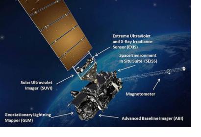
GOES-R. Courtesy of NASAGOES-R. Courtesy of NASA

The Geostationary Operational Environmental Satellite-R (GOES-R), recently launched by NASA, is the first in a sequence of highly advanced geostationary weather satellite to serve the National Oceanic and Atmospheric Administration (NOAA). The main goal of this satellite is to generate precise data to be used to create and isue opportune and precise watches, forecasts, and warnings.

After the checkout and validation of its six new instruments, the new satellite will be operational in approximately a year. Among the instruments there is the first operational lightning mapper in geostationary orbit, which forecasters will use to hone in on the greatest threats: storms.

The main instrument, the advanced Baseline Imager, will provide images of Earth’s weather, oceans and environment and climate sensors on board will monitor the sun and provide vital information so forecasters will be able to provide space weather alerts and warnings. The 34 weather products provided by GOES-R will be innovative meteorological solar and space weather ones. To know more about this satellite network please click here. 
NASA Successfully Launches NOAA Advanced Geostationary Weather Satellite
Tue, 22 Nov 2016 - 06:28
United States of America

Footer menu

  • Contact
  • Terms of Use

User account menu

  • Log in