• English
  • Español
  • Français

United
Nations


Office for Outer Space Affairs
UN-SPIDER Knowledge Portal

  • Home
  • About Us
    • What is UN-SPIDER?
    • About UNOOSA
    • Publications
    • Jobs
    • Meet the Team
    • Contact
  • Space Application
    • Satellite Technology
    • Emergency Mechanisms
    • Recovery Mechanisms
    • International Asteroid Warning Network
    • Space Mission Planning Advisory Group
    • International Space Weather Initiative
    • Space Technologies in the UN
    • User Stories
  • Links & Resources
    • Data Applications
      • Disaster Recovery
    • Data Sources
    • GIS and Remote Sensing Software
    • Online Learning Resources
    • Institutions
  • Risks & Disasters
    • Disaster Risk Management
    • Early Warning Systems
    • Emergency and Disaster Management
    • Natural Hazards
    • Sendai Framework
    • The UN and Disaster Risk Management
    • The UN and Early Warning
    • The UN and Disaster Management
  • Advisory Support
    • Advisory Missions
    • Emergency Support
    • Virtual Advisory Support
    • Recommended Practices
    • Training Activities
    • Practical Uses
  • Network
    • Regional Support Offices
    • GP-STAR
    • MHEWS
    • IWG-SEM
  • Projects
    • SPEAR
    • SEWS-D
    • EvIDENz
    • Flood GUIDE
  • News & Events
    • News
    • Events Calendar
    • UN-SPIDER Events Archive

Breadcrumb

  • Home
  • News and Events
  • View Active News
  • Measuring Earth’s Temperature
  • Measuring Earth’s Temperature

Measuring Earth’s Temperature

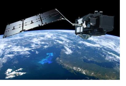
Sentinel-3A. Image: Courtesy of ESASentinel-3A. Image: Courtesy of ESA

The Sentinel-3A, one of the most complete Copernicus missions, has advanced instruments to measure the temperature on oceans, land, ice and atmosphere. After going through testing and improvements since its launch on February 2016, it has released high quality information from the Ocean and Land Colour Instrument in October this year.

This satellite is currently offering information from its Sea and Land Surface Temperature Radiometer.  This data can be used for ocean and weather forecasting activities by helping in the creation of global maps of sea-surface temperature.  In the case of land, this tool can perceive heat stress in order to improve agricultural practices and monitor urban heat islands, a major concern as urban expansion continues.

The radiometer includes measuring fire channels, a remarkable feature that will assist to assess damage and estimate recuperation of burned areas.  

Transforming information into ocean- and land- surface temperature maps requires additional data processing which will be published at the beginning of 2017.

This mission is mutually managed by ESA and Eumetsat, being the latest in charge of the day-to-day operations. While ESA is responsible for the land data products, Eumetsat is in charge of the marine ones. For more information on Sentinel-3A please click here. 
Sentinel-3A Takes Earth's Temperature
Thu, 1 Dec 2016 - 06:54
Europe

Footer menu

  • Contact
  • Terms of Use

User account menu

  • Log in