Following the massive earthquake and tsunami that hit Japan on 11 March, satellite imagery has been vital in providing a clear picture of the extent of devastation to aid the relief effort now underway. In response to this event, which turned out to be the biggest earthquake Japan has suffered in living memory, the International Charter 'Space and Major Disasters' was triggered by the Cabinet Office of Japan the same day the earthquake struck.
As a result, satellite images from several space agencies and operators from around the world are being used to map and assess the stricken areas. The value of the initiative lies in the way it has been set up to gather and coordinate a range of different satellite data, turn them into usable products and provide a single access point to the products 24 hours a day, 7 days a week, and at no cost to the user.
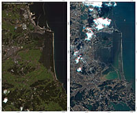
Demonstrating the incredible power that Earth can unleash, the devastation caused by the 8.9-magnitude quake has left the world stunned. Japan's northwestern coastline is thought to have shifted by as much as 4 m to the east and whole towns have been washed away by the tsunami, completely changing the landscape. Satellite maps are providing essential information for search and rescue teams on the ground and for damage assessment. Before-and-after images show how the land has changed and where buildings and roads once stood.
Over 63 satellite acquisitions were made in the first 48 hours following the event. These are being used by relief teams and decision-makers responding to the disaster. A large collaboration is at work to exploit data offering value-adding analysis with specialist centres from France (Sertit), Germany (DLR-ZKI) and the United Nations (UNITAR/UNOSAT), while JAXA provide dedicated mapping service to the Japanese authorities.
Over the coming weeks, access to updated satellite products will prove essential for continued crisis response and also to start precise damage assessment for recovery, rehabilitation and reconstruction. Satellite data will also be used to help further our understanding of these geological threats and ultimately help with future warning systems.