  • English
  • Español
  • Français

United
Nations


Office for Outer Space Affairs
UN-SPIDER Knowledge Portal

  • Home
  • About Us
    • What is UN-SPIDER?
    • About UNOOSA
    • Publications
    • Jobs
    • Meet the Team
    • Contact
  • Space Application
    • Satellite Technology
    • Emergency Mechanisms
    • Recovery Mechanisms
    • International Asteroid Warning Network
    • Space Mission Planning Advisory Group
    • International Space Weather Initiative
    • Space Technologies in the UN
    • User Stories
  • Links & Resources
    • Data Applications
      • Disaster Recovery
    • Data Sources
    • GIS and Remote Sensing Software
    • Online Learning Resources
    • Institutions
  • Risks & Disasters
    • Disaster Risk Management
    • Early Warning Systems
    • Emergency and Disaster Management
    • Natural Hazards
    • Sendai Framework
    • The UN and Disaster Risk Management
    • The UN and Early Warning
    • The UN and Disaster Management
  • Advisory Support
    • Advisory Missions
    • Emergency Support
    • Virtual Advisory Support
    • Recommended Practices
    • Training Activities
    • Practical Uses
  • Network
    • Regional Support Offices
    • GP-STAR
    • MHEWS
    • IWG-SEM
  • Projects
    • SPEAR
    • SEWS-D
    • EvIDENz
    • Flood GUIDE
  • News & Events
    • News
    • Events Calendar
    • UN-SPIDER Events Archive

Breadcrumb

  • Home
  • News and Events
  • View Active News
  • Keeping An Eye – From The Sky – On Volcanoes
  • Keeping an eye – from the sky – on volcanoes

Keeping an eye – from the sky – on volcanoes

The ‘Monitoring Volcanoes’ article made reference to a study of over 440 active volcanoes in 16 developing countries which revealed most volcanoes around the world are not monitored effectively  or are not monitored at all:  384 volcanoes have rudimentary or no monitoring, out of which 65 volcanoes  pose a high risk to large populations.

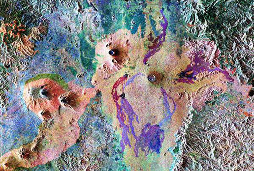
Earth observing satellites, such as ESA’s Envisat, can detect unrest of currently unmonitored volcanoes. Movement of magma underground may cause deformation of the surface above, thus InSAR can be used to monitor volcanoes. InSAR or Interferometric Synthetic Aperture Radar  is a remote sensing technique where two or more radar images over the same area are combined to detect slight surface changes occurring between acquisitions. Tiny changes on the ground lead to rainbow coloured interference patterns in the combined image.

Thus  Satellites are finding that volcanoes previously thought to be dormant are showing signs of unrest. 

ESA
Wed, 28 Mar 2012 - 10:46

Footer menu

  • Contact
  • Terms of Use

User account menu

  • Log in