• English
  • Español
  • Français

United
Nations


Office for Outer Space Affairs
UN-SPIDER Knowledge Portal

  • Home
  • About Us
    • What is UN-SPIDER?
    • About UNOOSA
    • Publications
    • Jobs
    • Meet the Team
    • Contact
  • Space Application
    • Satellite Technology
    • Emergency Mechanisms
    • Recovery Mechanisms
    • International Asteroid Warning Network
    • Space Mission Planning Advisory Group
    • International Space Weather Initiative
    • Space Technologies in the UN
    • User Stories
  • Links & Resources
    • Data Applications
      • Disaster Recovery
    • Data Sources
    • GIS and Remote Sensing Software
    • Online Learning Resources
    • Institutions
  • Risks & Disasters
    • Disaster Risk Management
    • Early Warning Systems
    • Emergency and Disaster Management
    • Natural Hazards
    • Sendai Framework
    • The UN and Disaster Risk Management
    • The UN and Early Warning
    • The UN and Disaster Management
  • Advisory Support
    • Advisory Missions
    • Emergency Support
    • Virtual Advisory Support
    • Recommended Practices
    • Training Activities
    • Practical Uses
  • Network
    • Regional Support Offices
    • GP-STAR
    • MHEWS
    • IWG-SEM
  • Projects
    • SPEAR
    • SEWS-D
    • EvIDENz
    • Flood GUIDE
  • News & Events
    • News
    • Events Calendar
    • UN-SPIDER Events Archive

Breadcrumb

  • Home
  • News and Events
  • View Active News
  • IGAC: Agro-climatic Drought Risk Management Using NDVI
  • IGAC: Agro-climatic Drought Risk Management using NDVI

IGAC: Agro-climatic Drought Risk Management using NDVI

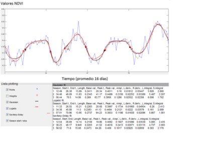
Time series of NDVI average 2001-2004 of clean pasture areasTime series of NDVI average 2001-2004 of clean pasture areas in the Atlántico region, Magdalena and Bolivar (northern Colombia).

Continuing progress in studies and advancing in the area of drought monitoring in agricultural areas, the Remote Sensing Group of the Center for Research and Development in Geographic Information of IGAC (CIAF) in Colombia, has been analyzing time series of the Normalized Differenced Vegetation Index (NDVI) based on MODIS data obtained by NASA's Terra satellite.

Specifically, the researchers used MOD13Q images to obtain historical data on the severity and duration of drought in different regions of the country.

To automatically determine the maximum and minimum NDVI values, and also to identify the start and the end of the seasonal periods of pastures, CIAF uses the freely available software TIMESAT. This programme allows to adjust three statistical models, Gaussian, logistic and Savitsky-Golay, to analyze the seasonality of any spectral index calculated. In this way, the team looks to model future climate anomalies such as El Niño and its possible impact on the agricultural sector.

The image above shows a time series of NDVI average from 2001-2004 for clean pasture areas in the Atlántico region, Magdalena and Bolivar (northern Colombia). This time period recorded an El Niño event from May 2002 (Time 30) to March 2003 (Time 60).

IGAC is the Agustin Codazzi Geographic Institute of Colombia and host to a UN-SPIDER's Regional Support Office.
IGAC
Thu, 28 Aug 2014 - 13:53
Colombia
Colombia Regional Support Office

Footer menu

  • Contact
  • Terms of Use

User account menu

  • Log in