
To support emergency response efforts, the International Centre for Integrated Mountain Development (ICIMOD) has mapped the extent of floods in Bangladesh following Cyclone Amphan, which caused widespread damage in the country and neighboring India in mid-May. The maps are based on Sentinel-1 radar imagery. Radar satellite data is commonly used for flood mapping purposes due to its ability to make measurements irrespective of daytime and cloud cover of the scene.
By providing an overview of the extent of inundation caused by the floods, these maps are useful in the context of disaster management, as humanitarian agencies are able to detect areas that have been affected by the floods the most and can coordinate relief and rescue activities accordingly.
The tropical cyclone caused at least 96 deaths in Bangladesh and inflicted substantial damage to infrastructure. The continuous flooding resulting from the cyclone comes during the ongoing COVID-19 pandemic, complicating social distancing norms significantly.
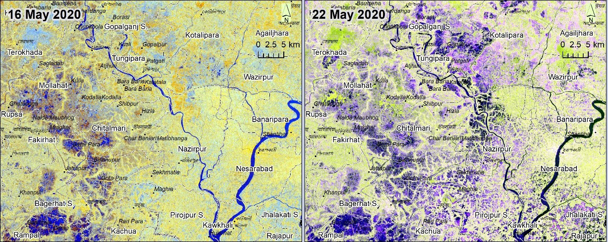
Figure 1. Pre/post flooding: Sentinel-1 satellite imageries from before (16 May) and after (22 May) Cyclone Amphan. The extent of inundation caused by the floods is assessed by comparing perennial waterbodies from before the cyclone with flooding caused by the cyclone, indicated by the blue sections of the maps. Image: ICIMOD.
Earth observation can support identifying flood-damaged areas after a disaster strikes as well as flood early warning and risk assessments. To support countries in making use of the benefits of space technologies, UN-SPIDER regularly publishes so-called Recommended Practices, which are step-by-step procedures for downloading, processing and mapping space-derived data. Its Recommended Practice on flood hazard assessments explains how to identify potential flood-prone areas and potentially affected infrastructure, namely roads, settlements, agriculture and in-land areas etc. against a flood hazard of particular return period i.e. 2, 5, 10, 25, 50 and 100 years. The Recommended Practice on flood mapping and damage assessments using Sentinel-1 data in Google Earth Engine help obtain a quick first overview of the situation to support emergency response efforts.
ICIMOD is one of 24 UN-SPIDER Regional Support Offices.