• English
  • Español
  • Français

United
Nations


Office for Outer Space Affairs
UN-SPIDER Knowledge Portal

  • Home
  • About Us
    • What is UN-SPIDER?
    • About UNOOSA
    • Publications
    • Jobs
    • Meet the Team
    • Contact
  • Space Application
    • Satellite Technology
    • Emergency Mechanisms
    • Recovery Mechanisms
    • International Asteroid Warning Network
    • Space Mission Planning Advisory Group
    • International Space Weather Initiative
    • Space Technologies in the UN
    • User Stories
  • Links & Resources
    • Data Applications
      • Disaster Recovery
    • Data Sources
    • GIS and Remote Sensing Software
    • Online Learning Resources
    • Institutions
  • Risks & Disasters
    • Disaster Risk Management
    • Early Warning Systems
    • Emergency and Disaster Management
    • Natural Hazards
    • Sendai Framework
    • The UN and Disaster Risk Management
    • The UN and Early Warning
    • The UN and Disaster Management
  • Advisory Support
    • Advisory Missions
    • Emergency Support
    • Virtual Advisory Support
    • Recommended Practices
    • Training Activities
    • Practical Uses
  • Network
    • Regional Support Offices
    • GP-STAR
    • MHEWS
    • IWG-SEM
  • Projects
    • SPEAR
    • SEWS-D
    • EvIDENz
    • Flood GUIDE
  • News & Events
    • News
    • Events Calendar
    • UN-SPIDER Events Archive

Breadcrumb

  • Home
  • News and Events
  • View Active News
  • Earth Observation of Night Time Lights For Flood Risk Management
  • Earth Observation of night time lights for flood risk management

Earth Observation of night time lights for flood risk management

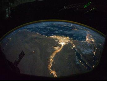
River Nile and its Delta hosting two of the biggest cities in EgyptCairo and Alexandria

Flood is one of the most common geohazards, which also costs most devastation to society. There are areas more vulnerable to floods, where measures are taken to mitigate the impacts, but further research is needed for identifying flood vulnerability in order to make communities in such vulnerable areas more resilient.

Professor Alberto Montanari from the University of Bologna found new ways of pinpointing vulnerable areas by using satellite observation of night time lights from homes or businesses and combining this data with river network data.

The Institute of Hazard, Risk and Resilience explains: "Since night lights are a useful indicator for human settlements it can be used to identify and prioritise vulnerable populations that live close to streams or rivers. The data presented by Montanari shows an increase in night lights in areas that are near rivers. In the case of countries in Asia the trends are especially pronounced. In North America the presence of night lights are actually decreasing but this could be due to the implementation of policies to reduce light pollution."
IHRR Blog
Wed, 19 Mar 2014 - 15:10
Italy

Footer menu

  • Contact
  • Terms of Use

User account menu

  • Log in