• English
  • Español
  • Français

United
Nations


Office for Outer Space Affairs
UN-SPIDER Knowledge Portal

  • Home
  • About Us
    • What is UN-SPIDER?
    • About UNOOSA
    • Publications
    • Jobs
    • Meet the Team
    • Contact
  • Space Application
    • Satellite Technology
    • Emergency Mechanisms
    • Recovery Mechanisms
    • International Asteroid Warning Network
    • Space Mission Planning Advisory Group
    • International Space Weather Initiative
    • Space Technologies in the UN
    • User Stories
  • Links & Resources
    • Data Applications
      • Disaster Recovery
    • Data Sources
    • GIS and Remote Sensing Software
    • Online Learning Resources
    • Institutions
  • Risks & Disasters
    • Disaster Risk Management
    • Early Warning Systems
    • Emergency and Disaster Management
    • Natural Hazards
    • Sendai Framework
    • The UN and Disaster Risk Management
    • The UN and Early Warning
    • The UN and Disaster Management
  • Advisory Support
    • Advisory Missions
    • Emergency Support
    • Virtual Advisory Support
    • Recommended Practices
    • Training Activities
    • Practical Uses
  • Network
    • Regional Support Offices
    • GP-STAR
    • MHEWS
    • IWG-SEM
  • Projects
    • SPEAR
    • SEWS-D
    • EvIDENz
    • Flood GUIDE
  • News & Events
    • News
    • Events Calendar
    • UN-SPIDER Events Archive
  • Admin
    • SAM Items

Breadcrumb

  • Home
  • News and Events
  • View Active News
  • Cuba Promotes Use of Satellite Remote Scanning and Detecting
  • Cuba promotes use of satellite remote scanning and detecting

Cuba promotes use of satellite remote scanning and detecting

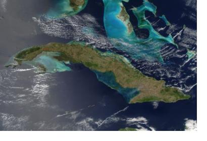
Cuba from space (Image: NASA)Cuba from space (Image: NASA)

At the Cuban Convention on Earth Sciences, the country presented “A Look to the Outer Space” which promotes the use of satellite remote scanning and detecting to be used for the country”s economy.

Dr. Manuel Iturralde, president of the Cuban Society of Geology, said that satellite technology has many applications in everyday life and social practice of Cuba. He continued that there are many groups working on issues involving the use of satellite pictures in their research and everyday practice in Cuba, and that is working on the creation of a national remote sensing center, which favors the work between those who work related to this specialty in the country.

According to Prensa Latina the Cuban expert stressed the importance of the use of satellite remote sensing use in areas such as agriculture, as well as in studies of risk prevention of disasters such as floods, drought and earthquakes. That discipline has applications also in meteorology, geology, mineral prospecting, mapping, urban planning, hydrography, oceanography, environmental monitoring, among other areas.

Nearly 1,000 professionals from 29 countries attended the 6th Cuban Earth Sciences Convention under the theme "Geosciences in the service of society and development". 
Prensa Latina
Mon, 11 May 2015 - 17:12
Cuba

Footer menu

  • Contact
  • Terms of Use

User account menu

  • Log in