A new Earth-observation satellite was successfully launched by China on Thursday, 7th April 2022, from the Jiuquan Satellite Launch Center in the north-western part of the country.
Long March-4C rocket launched Gaofen-3 03 at 7:47 a.m. (Beijing Time) and it went into orbit as planned.
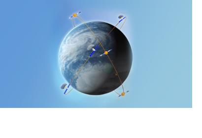
Together with two satellites from the Gaofen-3 series that have already been launched, the three will work together to make a "sky eye" in space.
The three satellites are all on the same orbital plane, and they work together to be more efficient by going around the Earth every 99 minutes.
To assist China's maritime development, environmental resource monitoring, and disaster prevention and mitigation, the design will increase the number of times satellites view the Earth, improve their revisiting capabilities, and expand worldwide coverage.
The Gaofen-3 02 and 03 include an auto-identification system (AIS) and other improvements over the first satellite of its type, launched in 2016.
With the new satellite network, it only takes five hours for a satellite to return to the same location as the first satellite, which took 3.5 days.
Using three satellites, the same region may be imaged five times a day with high-resolution synthetic aperture radar pictures.
Tuesday, 12th April, it was reported that data has been successfully received from the freshly launched Gaofen-3 03 satellite, according to the Aerospace Information Research Institute under the Chinese Academy of Sciences.
There were 44 gigabytes of data sent to the remote sensing satellite ground station in Miyun on the borders of Beijing and the ground station in southern China, Sanya.
Together with Gaofen-3 and Gaofen-3 02 satellites, Gaofen-3 03 satellite will provide a land-sea radar network capable of capturing high-quality synthetic aperture radar (SAR) imagery.
Image: A demonstration of China's geological environment and disaster monitoring and forecasting satellite constellation, August 23, 2017. (Image credit: China National Space Administration)

