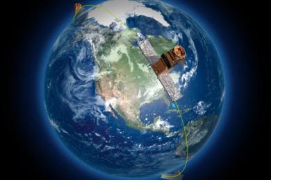
On 12 June 2019, a trio of identical Canadian Earth observation satellites, which will help monitor climate change and save lives during natural disasters, among other applications, were successfully launched into space from a SpaceX Falcon 9 rocket.
The satellites, collectively referred to as the RADARSAT Constellation Mission (RAM), follow the legacy of over two decades of Canadian RADARSAT satellites that have provided important insights about the Earth’s surface. RAM builds upon this foundation and will provide increased information for researchers to better understand our planet. According to a news release from the Canadian Space Agency, “The constellation of three satellites will provide daily images of Canada's vast territory and maritime approaches, as well as images of the Arctic, up to four times a day. It will have daily access to 90 per cent of the world's surface.” This represents an increase in coverage, in comparison to what Canada’s RADARSAT-2 satellite, which operates alone, is able to observe at any one point in time.
RAM’s use of Synthetic Aperture Radar (SAR) allows images to be captured day and night, and in cloudy conditions, making it a valuable resource for accruing continuous data and monitoring changes in the Earth’s surface over time. This enhanced visibility function is also critically important for response efforts during natural disasters, when cloud cover resulting from rain or smoke often emerges. In comparison with traditional optical satellites and aerial image techniques, which are often less effective when attempting to see through clouds, SAR imagery allows emergency first responders to gain a clearer view of the Earth’s surface, better identify problem areas, and focus their efforts on the right locations in order to save lives and reduce damages.
Data collected by RAM will also be used to track changes in permafrost and ground movement, which helps individuals and local Canadian authorities make safe decisions when constructing homes and infrastructure. Additionally, RAM imagery can help in monitoring the stability of infrastructure, like highways, bridges, and railways, among other uses. These applications are important for improving safety and reducing the likelihood and impact of damage, which are core components of disaster risk reduction. Moreover, as the Canadian Space Agency is a contributing member of the International Charter “Space and Major Disasters,” RAM data will be available to assist countries around the world in times of need.

