![]()
United
Nations
World Water Quality Information and Capacity Building Portal (IIWQ - UNESCO/IOC, EOMAP)
| Data provided by: | Intergovernmental Oceanographic Commission (UNESCO/IOC), EOMAP |
| Data accessibility: | visualization of data (e.g. web GIS or real time monitoring) |
| Link to the data: | |
| File type: | webmap |
| Data type: | hazard specific data |
| Hazard: | Harmful Algal Bloom, Pollution |
| Disaster cycle phase: | Disaster Risk Management, Response, Recovery |
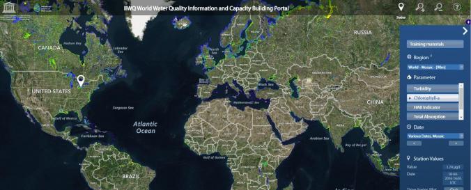
| Space-based Information: | The World Water Quality Information and Capacity Building Portal (IIWQ) is a webmap that illustrates data on turbidity, chlorophyll-a, total absorption as well as the EOMAP specific harmful algal bloom indicator (HAB indicator). Where access to in-situ data is available station values are presented. |
| Satellites and Sensors: | Landsat 7, Landsat 8, Sentinel-3A |
| Spatial coverage: | Global |
| Spatial resolution: | 10m |
| Temporal coverage: | Near-real time |
| Content dates: | varying |
| Technical Specifications: | |
| Costs: | free |
| Contact: | UNESCO IIWQ |
| Tutorials on the use of data: | User Guide, Whitepaper, Training Materials |
| Restrictions/ Citation of the dataset: |
Provider
![]()