![]()
United
Nations
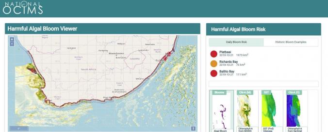
Harmful Algal Bloom Viewer (National OCIMS)
| Data accessibility: | visualization of data (e.g. web GIS or real time monitoring) |
| Link to the data: | |
| Requirements: | Web-browser and Java |
| File type: | webmap |
| Data type: | hazard specific data |
| Hazard: | Harmful Algal Bloom |
| Disaster cycle phase: | Disaster Risk Management, Response, Recovery |
| Space-based Information: | Webmap of Algal bloom detections, CHl-A from MODIS nFLH, Sea Surface Temperature (Odyssea), Chlorophyll-A from Sentinel OLCI. The HAB Decision Support Tool (DeST) provides a capability for monitoring and assessing risk of HAB events for the South African coastal area to approximately 50km offshore. Risk assessment and monitoring is based on quantified understanding of bloom dynamics (Pitcher & Nelson, 2006), hypoxic impacts (Pitcher et al 2014), and earth observation monitoring capabilities (Bernard et al 2006). Maps of various ocean colour-derived phytoplankton biomass proxies, sea surface temperature, and ocean state (wind, current, sea state) are used to provide information on the presence and movement of blooms, and extracted time series of these data provide a "virtual buoy" capability giving a multi-parameter risk index. |
| Satellites and Sensors: | Aqua, Sentinel-3A |
| Temporal coverage: | Near-real time |
| Costs: | free |
| Contact: | Forum |
| Restrictions/ Citation of the dataset: | OCIMS |
Provider
![]()