
What is free satellite data used for?
Satellite data can be applied for monitoring almost any natural hazard across the globe, and is therefore a crucial component for all phases of the disaster management cycle. More and more satellite imagery is available for free, and the image archives are continuously growing. This is a great data treasure, which is still underexploited for operational disaster and risk management. Some good examples of data usage are outlined below.
In relation to the response phase of a disaster, the Copernicus GIO Emergency Mapping Service (GIO EMS-Mapping) utilises freely accessible satellite data (such as Sentinel-1imagery), as well as commercial data, to provide all involved actors with timely and accurate geospatial information relating to that particular disaster. The resulting information products can be used as supplied (e.g. as digital or printed map outputs), or may be further combined with other data sources (e.g. as digital feature sets in a geographic information system). In both cases, it is hugely beneficial for supporting geospatial analysis and decision making processes of emergency managers.
In the recovery phase of the disaster management cycle free satellite data is used for loss and damage assessment. For example, through the use of high resolution freely accessible satellite imagery (such as SPOT imagery), it is possible to analyse the amount of land lost to burning following a forest fire. By using free satellite data for loss and damage assessment, this enables emergency managers to more effectively plan how they can go about the recovery/rehabilitation of a disaster struck area.
Free satellite data is also used to aid with Disaster Risk Reduction (DRR). Exposure, vulnerability and risk assessments make use of freely accessible satellite data to map areas that are vulnerable or at high risk to natural disasters, and by utilizing this knowledge, emergency managers can increase mitigation efforts in these vulnerable areas in order to reduce the impact of any future occurring disasters. UN-SPIDER is an active member of the Global Partnership, which spearhead efforts regarding the use of Earth Observations and Space-based applications to contribute to the monitoring and implementing of the targets of the Sendai Framework for Disaster Risk Reduction 2015-2030. Explicitly, space-based information can contribute to target b on affected population (e.g. by using of EO-derived population data, downscaling of administrative population data, use of settlement information like the Global Human Settlement Layer or the Global Urban Footprint), to target c on economic loss (e.g. economic loss in the agricultural sector using satellite-derived crop information), to target d on disaster damage to critical infrastructure (e.g. exposure and vulnerability mapping at national level), and target g on early warning and risk information (e.g. using image archives for information on changes in risks over time).
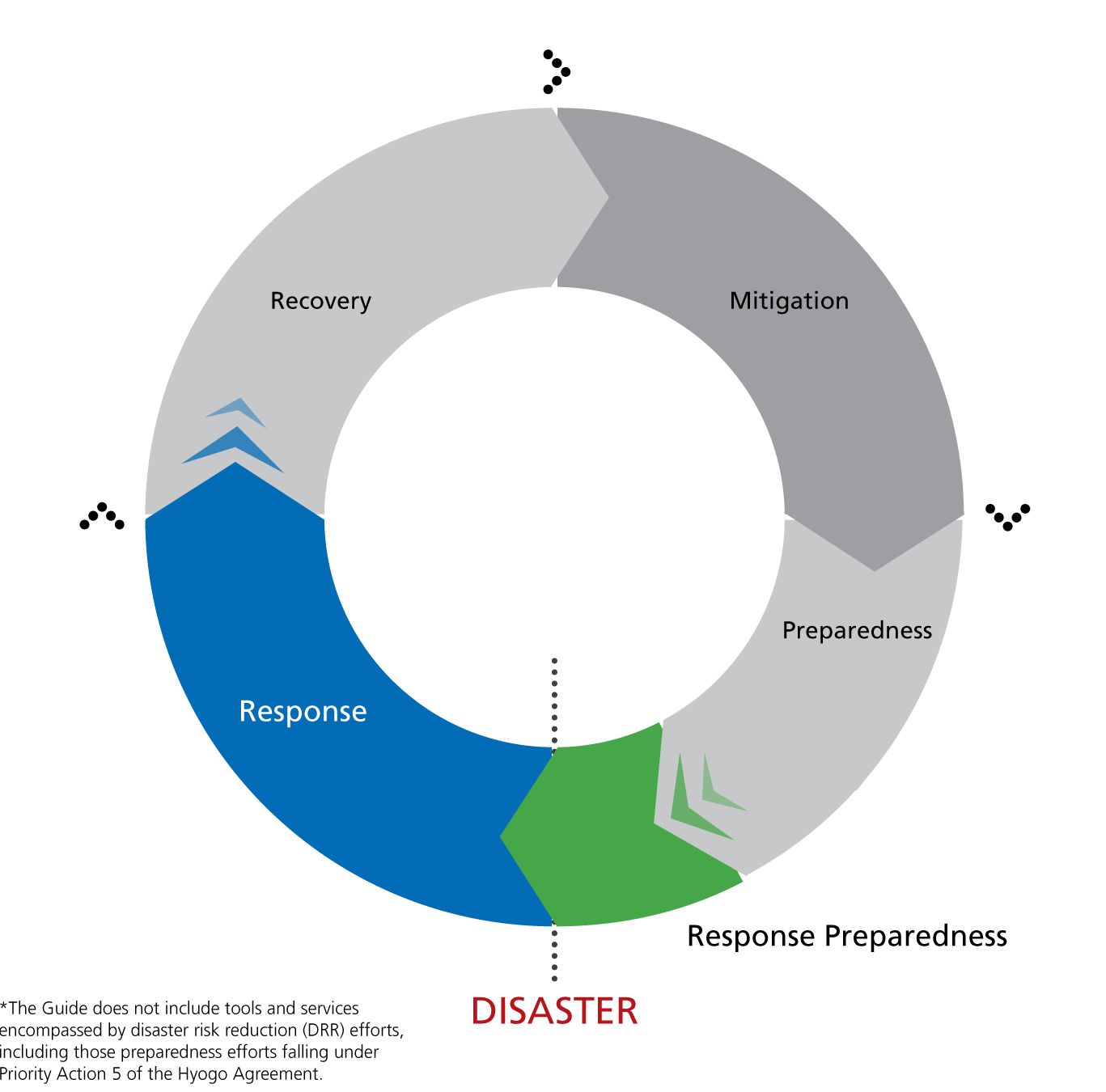
Figure 1: Disaster Management Cycle (Source: UNOCHA, Disaster response in Asia and The Pacific)
How is free satellite data processed to extract meaningful information?
Once remotely sensed data has been obtained by the satellite, there are several steps in the processing chain through which it needs to pass before meaningful freely accessible information can be extracted by the user. The following methodology describes the key processes in this chain:
How can I access free satellite data?
Free satellite data is obtainable for both optical (passive) an SAR (active) satellite sensors, at various different resolutions. The majority of freely accessible satellite data can be downloaded via Earth Explorer, EO Portal, or the Sentinel Scientific Data Hub.
Optical (passive)
Very high resolution:
High resolution:
Medium resolution:
MODIS Level 1, Atmosphere and Land data products (NASA)
SAR (active)
High resolution:
How are the datasets used for disaster risk management and emergency response?
Free satellite data is commonly used for many different purposes in disaster risk management and emergency response. Below are two case study examples from previous articles on the Knowledge Portal, which indicate the broad range of applications to which free satellite data can be applied.
1) The Iranian Space Agency, one of UN-SPIDER Regional Support Offices, has prepared a recommended practice on drought monitoring, which is used for monitoring the impacts of meteorological drought on natural vegetation. Based on NDVI data derived from freely accessible MODIS satellite data, the Vegetation Condition Index (VCI) is calculated to assess whether the state of the vegetation in a current month is better or worse compared to same month of the previous years. More information in relation to this case study is available here on the Knowledge Portal.
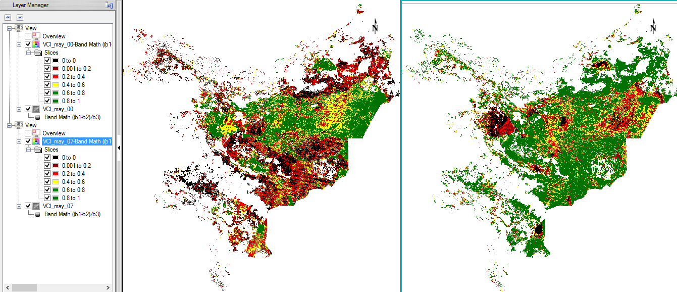
Figure 2: Resulting Vegetation Condition Index (VCI) for Iran, derived from freely accessible MODIS data (https://www.isa.ir/)
2) Using freely accessible MODIS hotspot (also known as active fire products or hotspots) data, a study was undertaken in Thailand to examine the quality and precision of using satellite data for forest fire control and management. A quantitative evaluation of MODIS hotspot products was carried out for the 2007-2009 forest fire seasons. High accuracy of 91.84 %, 95.60% and 97.53% for the 2007, 2008 and 2009 fire seasons were observed, resulting in increased confidence in the use of MODIS hotspots for forest fire control and management in Thailand. More information in relation to this case study is available here on the Knowledge Portal.