The Coyolate river is one of several rivers that originates in the highlands of Guatemala and in the foothills of the Fuego and Acatenango volcanoes. Its lower basin, in the Pacific coastal plains, experiences floods triggered by intense precipitation and is affected by massive sedimentation as a result of the transport of volcanic material from the cone of the active Fuego volcano during the rainy season.
Several decades ago, the former National Emergency Committee and more recently the National Coordinating Agency for Disaster Reduction (SE-CONRED) have conducted efforts in communities located in the floodplain of the Coyolate river to enhance disaster preparedness, including through the implementation of a community-based flood early warning system in 1997.
At the request of UN-SPIDER, the Geographic Information Systems Department of SE-CONRED conducted a comparative analysis of the modelling of floods using two digital elevation models (DEM):
- The DEM developed by the United States National Aeronautics and Space Administration (NASA) based on its Shuttle Radar Topography Mission (SRTM), and
- The WorldDEMTM developed by Airbus Defence and Space GmbH.
Both data sets are digital surface models (DSM), which represent the surface of the Earth including buildings, infrastructure and vegetation.
This comparison was conducted using the IBER software version 2.3.2. Figure 1 presents the geographic area where this analysis was conducted.
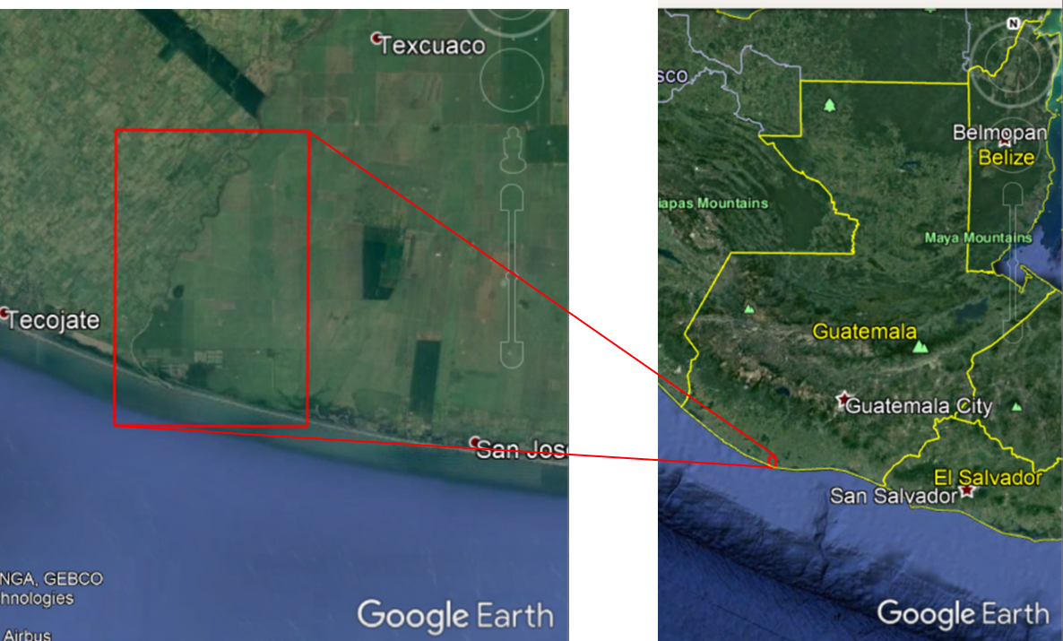
Figure 1: Segment of the floodplain of the Coyolate river in Guatemala where the flood modelling was conducted.
This article presents the results of this comparison.
Data and model
Flood modelling in this segment of the floodplain of the Coyolate river was conducted using data related to floods with a period of return of 50 years. Two digital elevation models were used in the comparison:
- The digital elevation model WorldDEMTM developed by Airbus Defence and Space GmbH, and
- The digital elevation model developed from the Shuttle Radar Topography Mission (SRTM) of the United States National Aeronautics and Space Administration (NASA).
Table 1 presents the characteristics of these two digital elevation models:
| PARAMETER | WORLDDEMTM | SRTM DSM |
|---|---|---|
| XY coordinate system | GCS WGS 1984 | GCS WGS 1984 |
| Vertical coordinate system | EGM2008 geiod height | EGM1996 geiod height |
| Resolution | 0.4 arc sec (approx. 12m) | 1 arc sec (approx. 30m) |
| Vertical accuracy | 2m (relative) / 4m (absolute) | 16m (with 90% confidence) |
| Data acquisition date | 2011 - 2015 | 2000 |
Table 1: Comparison of parameters of WorldDEMTM and SRTM
For this analysis, the following parameters were employed:
Discharge (period of return = 50 years): 730 – 1530 m3/s
Manning coefficient:
River: 0.25
Main channel: 0.04
Floodplain: 0.07
Flood modeling was conducted using the software IBER version 2.3.2 and the software iRIC version 3.9.0.62. Figure 2 shows the results regarding discharge in the area of interest. 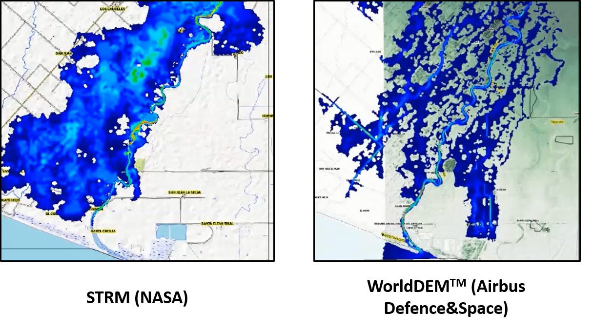
Figure 2: Comparison of the specific discharge according to the SRTM DEM (left) and WorldDEMTM (right).
Analysis
The use of IBER software and the two DEMs leads to the following results:
- The area affected by floods is wider when using the WorldDEMTM and narrower when using the SRTM DEM. In addition, when using the SRTM DEM, simulated floods take place mostly in the western side of the channel of the river. When using WorldDEMTM, simulated floods take place in the two sides of the channel of the river.
- When using the SRTM DEM, the flooded area is wide, with few islands and few areas not inundated. When using WorldDEMTM, simulated floods appear in some regions of the floodplains, while other areas of the floodplains remain unaffected. This result is in line with aerial photographs of the lower basin of the river during floods, where some areas are flooded while other areas are not flooded.
The differences can be attributed to the higher resolution of the WorldDEMTM that allows for a more precise detection of small differences in elevation in the area of interest.
Focusing on Santa Odilia village
Through the use of the iRIC software and WorldDEMTM, it is possible to identify that one of the communities exposed to floods called Santa Odilia village is located in a region that is slightly higher than neighboring areas. Nevertheless, the modelling of floods with this software and the WorldDEMTM indicates that in case of a large flood, this village will be incommunicated by land, meaning that any humanitarian assistance will need to be delivered using boats or helicopters. Figure 3 presents the location of Santa Odilia village and the simulated floods around it.
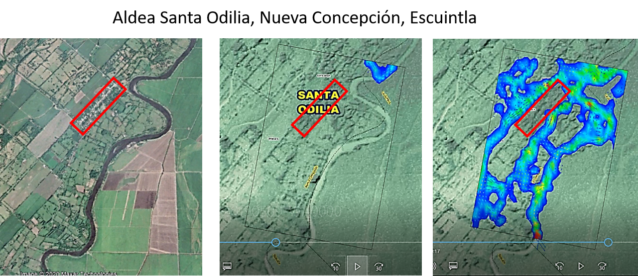
Figure 3: Santa Odilia village in the Coyolate floodplains and modelling of floods in the vicinity. As can be seen, in case of floods the village may not be inundated, but access to the village by road will not be possible.
Conclusions
The comparison of the results of the flood modelling using WorldDEMTM and SRTM DEM leads to the conclusion that the higher resolution of WorldDEMTM allows for the modelling of floods with higher precision, identifing more precisely which areas will be flooded and which areas may not be flooded.
Nevertheless, it is important to stress that these DEMs were developed on the basis of space missions conducted in different decades and so, there may be some differences which have to be attributed to changes in morphology of the river and sorrounding areas over time. Changes over time in the lower basin of the Coyolate river may be due to:
- Changes in crop types (land-cover) at the time the SRTM mission was conducted and at the time when the satellite imagery used to develop the WorldDEMTM were acquired.
- Changes in the morphology of the channel due to transport of sediments (volcanic material) or the construction of levees to minimize floods over those two decades.
It is important to be aware of the different characteristics of WorldDEMTM and SRTM to be able to correctly evaluate the results. The main differences are:
- Acquisition dates: The acquisition period of WorldDEMTM is December 2010 to January 2015 and thus the WorldDEMTM is more than 10 years more up to date than SRTM (SRTM acquisition time is February 2000).
- Accuracy: The vertical accuracy of WorldDEMTM with a global average of LE90ABS less than 4 meters, which is much higher than SRTM (LE90ABS less than 16m)
- Resolution: The level of detail of WorldDEMTM has a relative accuracy of less than 2 meters for slopes less than 20%; and less than 4 meters for slope above 20%. This is very beneficial in regions of moderate and plain terrain where accuracy of flood modelling results strongly correlates with the accuracy of the DEM used as input.
To compare WorldDEMTM to SRTM, the WorldDEMTM digital surface model has been used. However, to reduce the impact of surface features such as vegetation, digital terrain models (DTM) are usually preferred for the purpose of flood modelling. Since 2019 Airbus Defence and Space GmbH offers a global, automatically derived DTMlite product in a resolution of 24 meters.
Acknowledgements
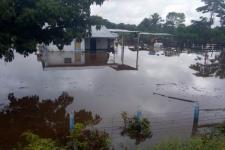
![]() This user story has been provided by Danilo Juarros of the Executive Secretariat of the National Coordinating Agency for Disaster Reduction of Guatemala (SE-CONRED). The first image of the article, courtesy of CONRED, shows floods in Las Cruces, Petén, in 2019.
This user story has been provided by Danilo Juarros of the Executive Secretariat of the National Coordinating Agency for Disaster Reduction of Guatemala (SE-CONRED). The first image of the article, courtesy of CONRED, shows floods in Las Cruces, Petén, in 2019.
The WorldDEMTM data has been provided by Airbus Defence and Space GmbH in the framework of the MOU between UNOOSA and Airbus Defence and Space.
References
- IBER software: https://www.iberaula.es/
- NASA SRTM: https://www2.jpl.nasa.gov/srtm/
- WorldDEMTM Technical Product Specification Document, Version 2.5, April 2019
- WorldDEMTM DTMlite Technical Product Specification Document, Version 1.0
- WorldDEMTM of Airbus Defence and Space Website: https://www.intelligence-airbusds.com/en/8703-worlddem