![]()
United
Nations
Volcanic Eruption
 on the Landsat 8 satellite acquired this top image of Mount Etna on December 28, 2018. The image highlights the active vent and thermal infrared signature from lava flows, which can be seen near the newly formed fissure on the southeastern side of the volcano. The image was created with data from OLI (bands 4-3-2) and the Thermal Infrared Sensor (TIRS) on Landsat 8. Image: NASA.")
Definition
Facts and figures
Further information
UN-SPIDER Regional Support Offices with hazard-specific expertise
Related content on the Knowledge Portal
") Publishing institution:
Publishing institution: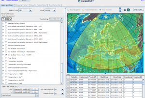 Meteosat 10 (SEVIRI-MSG), Meteosat 9 (SEVIRI-MSG), Meteosat 8 (SEVIRI-MSG), Meteosat 7 (MVIRI-MTP), Meteosat 6 (MVIRI-MTP), Meteosat 5 (MVIRI-MTP), Meteosat 4 (MVIRI-MTP), Meteosat 3 (MVIRI-MTP), Meteosat 2 (MVIRI-MTP), Metop (IASI), Metop (GOME-2), Metop (ASCAT), Metop (AMSU-A), Metop (MHS), Metop (AVHRR), Metop (GRAS), Metop (HIRS), Metop (A-DCS), Metop (SARSAT), Metop (SEM)Publishing institution:
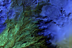 Publishing institution:


-
The Azores archipelago is exposed to different geological and meteorological hazards already responsible for thousands of deaths and severe damages. In order to detect precursory signals and develop early warning systems a multi-parametric monitoring network is under operation. Geophysical, geodetic, geochemical and meteorological independent techniques provide data that are integrated in the scope of a continuous hazard and risk assessment programme to support civil protection regional and local authorities.
On 13 September 2012, Fuego volcano in Guatemala again erupted, forcing the National Coordinating Agency for Disaster Reduction (CONRED) to declare an institutional "Orange Alert" and evacuated more than 10,000 inhabitants from communities located on the foothills of this volcano. The Departmental and Municipal Coordinating Agencies for Disaster Reduction (CODRED and COMRED respectively) also decalred orange alerts within their jurisdictions as a way to prevent loss of life. Given the fact that this is the rainy season in Guatemala, CONRED also is observing this activity with a particular focus on potental lahars which may manifest themselves in the Guacalate and Achiguate rivers. Using satellite imagery from MODIS TERRA, CATHALAC, one of UN-SPIDER's Regional Support Offices, elaborated maps depicting how the ash cloud was dispersed to the west of the volcano.
On Saturday evening 19 May 2012, the volcano also manifested a…
read more
UN-SPIDER Regional Support Offices with hazard-specific expertise
![]()