  • English
  • Español
  • Français

United
Nations


Office for Outer Space Affairs
UN-SPIDER Knowledge Portal

  • Home
  • About Us
    • What is UN-SPIDER?
    • About UNOOSA
    • Publications
    • Jobs
    • Meet the Team
    • Contact
  • Space Application
    • Satellite Technology
    • Emergency Mechanisms
    • Recovery Mechanisms
    • International Asteroid Warning Network
    • Space Mission Planning Advisory Group
    • International Space Weather Initiative
    • Space Technologies in the UN
    • User Stories
  • Links & Resources
    • Data Applications
      • Disaster Recovery
    • Data Sources
    • GIS and Remote Sensing Software
    • Online Learning Resources
    • Institutions
  • Risks & Disasters
    • Disaster Risk Management
    • Early Warning Systems
    • Emergency and Disaster Management
    • Natural Hazards
    • Sendai Framework
    • The UN and Disaster Risk Management
    • The UN and Early Warning
    • The UN and Disaster Management
  • Advisory Support
    • Advisory Missions
    • Emergency Support
    • Virtual Advisory Support
    • Recommended Practices
    • Training Activities
    • Practical Uses
  • Network
    • Regional Support Offices
    • GP-STAR
    • MHEWS
    • IWG-SEM
  • Projects
    • SPEAR
    • SEWS-D
    • EvIDENz
    • Flood GUIDE
  • News & Events
    • News
    • Events Calendar
    • UN-SPIDER Events Archive

Breadcrumb

  • Home
  • Taxonomy Pages
  • Taxonomy Pages

Dominica

country taxonomy block

CATHALAC: Support to flood-stricken Eastern Caribbean islands
In some areas, rainfall was 1839 percent above the average

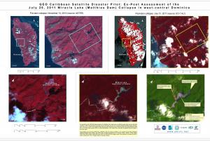
Between December 24 and 25, 2013, the eastern Caribbean islands of Dominica, Saint Lucia and Saint Vincent and the Grenadines were affected by torrential rains which triggered massive flooding and local landslides. The Associated Press reported that on the three islands, there were some 20 casualties. The Prime Ministers of those countries declared the state of national disaster, and even the head of the Organization of American States gave a statement on the tragedy.

In response to requests coming from the affected countries, and in the context of CATHALAC's role as a UN-SPIDER Regional Support Office in the region, CATHALAC's Division of Applied Research and Development prepared an analysis of the events triggering the disaster. The analysis was based on satellite-derived estimates of rainfall, principally from NOAA's Satellite and Information Service (NESDIS), and climatology data from the WorldClim 1.4 database. The results of the analysis showed that a…

more
Publishing date 30/01/2014
Regional Support Offices mentioned:
Water Center for the Humid Tropics of Latin America and the Caribbean (CATHALAC)
CDEMA publishes situation report on the Matthieu Dam's collapse

In the early morning of July 28, 2011, Dominica's Matthieu Dam was breached, damaging infrastructure downstream in the Layou River valley. In the context of the ongoing Caribbean Satellite Disaster Pilot, an initiative involving a host of entities including the Caribbean Disaster & Emergency Management Agency, CATHALAC, NASA, UN-SPIDER, and others, recently completed an assessment of the Matthieu Dam collapse. That assessment indicates that the collapse of the Matthieu Dam reduced the Miracle Lake's surface by some ~8.25 hectares, and as evident in the July 31, 2011 imagery, the banks of the Layou River below the Dam were also breached, putting an additional 4.58 hectares of land under water.

Please follow the link to the original article for a situation report on the Matthieu Dam's collapse.

Publishing date 17/08/2011

Footer menu

  • Contact
  • Terms of Use

User account menu

  • Log in