  • English
  • Español
  • Français

United
Nations


Office for Outer Space Affairs
UN-SPIDER Knowledge Portal

  • Home
  • About Us
    • What is UN-SPIDER?
    • About UNOOSA
    • Publications
    • Jobs
    • Meet the Team
    • Contact
  • Space Application
    • Satellite Technology
    • Emergency Mechanisms
    • Recovery Mechanisms
    • International Asteroid Warning Network
    • Space Mission Planning Advisory Group
    • International Space Weather Initiative
    • Space Technologies in the UN
    • User Stories
  • Links & Resources
    • Data Applications
      • Disaster Recovery
    • Data Sources
    • GIS and Remote Sensing Software
    • Online Learning Resources
    • Institutions
  • Risks & Disasters
    • Disaster Risk Management
    • Early Warning Systems
    • Emergency and Disaster Management
    • Natural Hazards
    • Sendai Framework
    • The UN and Disaster Risk Management
    • The UN and Early Warning
    • The UN and Disaster Management
  • Advisory Support
    • Advisory Missions
    • Emergency Support
    • Virtual Advisory Support
    • Recommended Practices
    • Training Activities
    • Practical Uses
  • Network
    • Regional Support Offices
    • GP-STAR
    • MHEWS
    • IWG-SEM
  • Projects
    • SPEAR
    • SEWS-D
    • EvIDENz
    • Flood GUIDE
  • News & Events
    • News
    • Events Calendar
    • UN-SPIDER Events Archive

Breadcrumb

  • Home
  • Taxonomy Pages
  • Taxonomy Pages

Chad

country taxonomy block

International Charter again activated for Floods in Africa

The International Charter "Space and Major Disaster" was activated twice last week for floods in Africa: Chad and Nigeria.

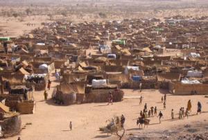
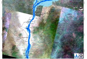
UNITAR/UNOSAT on behalf of UNICEF activated the mechanism for Chad on 10 October 2012. Heavy rains which started in early August had caused continuing floods in Chad. Hundreds of thousands of people have been affected by the floods, with damage to both property and agriculture. In the Rig Rig District of the Kanem Region, 220 houses were destroyed and 3000 people were displaced. In the Sila Region, more than 13,000 houses were affected and the flood waters blocked major humanitarian supplies. In Guera, an estimated 850 people were in need of emergency support. And floods have also been reported in the capital, N'Djamena. In September the flood waters were still present, and had affected an estimated 466,000 people, and killed 34. 96,000 houses were reported destroyed and 255,000 hectares of crops lost.

In Nigeria, the Nigerian National…

more
Publishing date 15/10/2012
Satellite Images Help Doctors Count People from Space

For the first time, the population of an entire city has been estimated from space through a pioneering project to speed up medical and disaster relief efforts. By analysing satellite images of disaster zones and famine, war or disease-hit areas where census data is unreliable, or cities unreachable, researchers hope to make rapid and more accurate estimates of how many people might need help.

"Population numbers are crucial to everything we do," says Ruby Siddiqui of the global charity, Medicins Sans Frontières, a collaborator in the project to evaluate the satellite counting technique. "We need to plan the size, scale and mode of interventions, and without population numbers we can't do this," she says.

At present, groups like MSF rely on the "quadrat" method to estimate population size. Surveyors visit a sample of individual households to find out how many people live in each type of dwelling. From this, they estimate the…

more
Publishing date 30/05/2012

Footer menu

  • Contact
  • Terms of Use

User account menu

  • Log in