Estimate Hectares of Forest Destroyed or Damaged by Fire for the Sendai Framework Indicator C-2Fo
Fires continue to destroy thousands to hundreds of thousands of hectares of forests and wildlands around the world every year. Furthermore, the United Nations Development Programme (UNDP) recognises that global warming will lead to an increase in the number and severity of forest fires in years to come. As a first step to address the challenges of wildfires, it is important to assess their geographical location and their severity. This information can be useful to implement restrictions on land use and to identify measures to ensure the recovery of such wild areas.
The Global Wildfire Information System (GWIS) is a joint initiative of the Group on Earth Observations (GEO) and Copernicus Work Programs. GWIS aims to bring together existing information sources at the regional and national levels in order to provide a comprehensive evaluation of fire regimes and fire effects at a global scale, and support operational wildfire management from national to global levels. In 2021, GWIS launched its Country Profiles application which provides national-level statistics and historical data of fires, including yearly burned area by landcover class statistics generated from MODIS and ESA land cover products.
The historical data included in GWIS can be used to track the historical trends of forest fires in any country of the world in the last two decades. Such data can be used to elaborate an ad-hoc indicator for the Sendai Framework Monitor that governments use to report on progress in the implementation of this framework. The Sendai Framework includes seven targets and indicators have been designed to capture trends over the years. One of those indicators addresses the trends in the number of hectares that have been burnt on an annual basis.
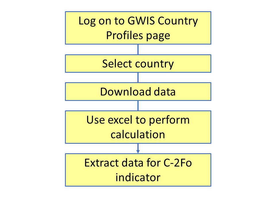
This page provides a practical use of GWIS for national focal points to report on the number of hectares of forests damaged/destroyed by fire in reference to Target C of the SFDRR where country data for estimating directing economic loss is not available.
This procedure is designed to be used by those staff at government agencies in charge of compiling and entering information related to specific Sendai Framework indicators. Specifically, for those who have to enter data on indicator C-2Fo related to the impact of wildfires.
The Sendai Framework for Disaster Risk Reduction 2015-2030 (SFDRR) is the global blueprint for disaster risk reduction (DRR), which recognises that each State has the primary responsibility to prevent and reduce disaster risk, including through international, regional, subregional, transboundary and bilateral cooperation. Member states are encouraged to report on their progress towards the seven Sendai Framework global targets using the online Sendai Framework Monitor (SFM).
Geographical applicability:
This Ad-hoc indicator can be applied in most countries of the world, at the national or provincial level.
Neither UN-SPIDER nor the Regional Support Offices (RSOs) or their partners take any responsibility for the correctness of outputs from this practical use or decisions derived as a consequence.