Japan needs maps. Not just any kind—detailed informational maps georegistered with latitude and longitude and annotated with simple, self-evident details: this bridge is out, this port is damaged, this farm field is scoured; this one is verdant.
Researchers at Rochester Institute of Technology are processing satellite imagery of regions in Japan affected by the 9.0 magnitude earthquake and tsunami that devastated sections of the country's east coast on March 11. The U.S. Geological Survey, a member of the International Charter "Space and Major Disasters," organized the volunteer effort involving about 10 organizations, including Harvard University, George Mason University, Penn State and the Jet Propulsion Laboratory.
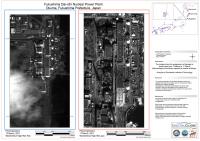
RIT signed on to process images of the Fukushima Nuclear Power Plant and the cities of Hachinohe and Kesennuma. At the request of the Japanese, scientists at RIT created before-and-after images that can be printed on large sheets of paper. The team uploads 30 megabyte PDFs to the U.S. Geological Survey's website for charter members and Japanese emergency responders to access. The RIT team processed imagery looking down into the reactors and the containment shells on March 12, the day after the earthquake and tsunami hit and prior to the explosions at the plant. High-resolution image-maps from March 18 show extensive damage and a smoldering reactor.