A magnitude 7.9 earthquake occurred at 2:46 pm on March 11, 2011 near the east coast of Honshu, Japan. Tsunami warnings are issued along the Pacific coast line. (source: http://glidenumber.net/glide/public/search/details.jsp?glide=19439&record=1&last=4953)
Japan has suffered a massive earthquake and tsunami in its northeast coast. Meanwhile, nations in the western pacific from Indonesia to the Philippines are bracing for the possibility of tsunamies of their own. (source: http://www.dw-world.de/dw/article/0,,14904492,00.html)
UNOOSA/UN-SPIDER
Email: un-spider [at] unoosa.org
Link: http://www.un-spider.org
Satellite imagery and maps on Honshu earthquake and tsunami, Japan.
You have found further data sources? Please get in touch with us: unspider [at] unoosa.org (subject: Data%20sources%20Japan%20earthquake) (unspider[at]unoosa[dot]org)
Status Update: 07 March 2012
Page content:
1.1. Space based rapid mapping products
1.2. Institutional links to further mapping products, geodata, geolinks and databases
- Space-based Resources
- Earthquake/Tsunami Warning Centers
- Emergency Response, Situation Reports
- Media
- Coordinates of affected areas (AOI)
- Contact
please click twice on links above to jump to a section
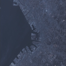
Japan earthquake overview by German Aerospace Center (DLR), Center for Satellite Based Crisis Information (ZKI) (click for high resolution image and KML file)

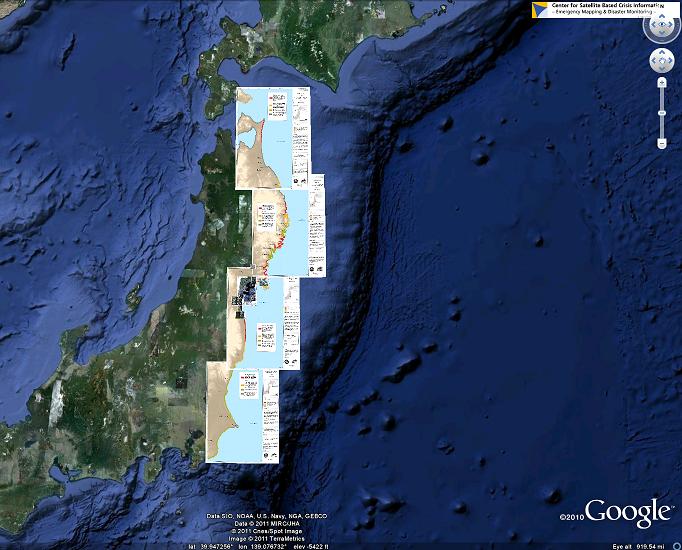
Click on the Google Earth screenshot to get an overview of recent map products (Google Earth required):
A magnitude 7.9 earthquake occurred at 2:46 pm on March 11, 2011 near the east coast of Honshu, Japan. Tsunami warnings are issued along the Pacific coast line. (source: http://glidenumber.net/glide/public/search/details.jsp?glide=19439&record=1&last=4953)
Japan has suffered a massive earthquake and tsunami in its northeast coast. Meanwhile, nations in the western pacific from Indonesia to the Philippines are bracing for the possibility of tsunamies of their own. (source: http://www.dw-world.de/dw/article/0,,14904492,00.html)
In the aftermath of the earthquake in Japan the German Aerospace Center (DLR) is actively involved in emergency mapping efforts in the frame of the International Charter Space and Major Disasters.
In case of any further question concerning DLR’s activities please contact the responsible press relations officer, Mr. Andreas Schuetz. Tel: +49 171 3126466; email: andreas.schuetz [at] dlr.de
1. Emergency Mapping
1.1 Space based rapid mapping products
| Source | Satellite/Instrument | Date | Area | Type | Status | Product/ Link |
|---|---|---|---|---|---|---|
| CHARTER | various actual mapping products | various | various areas | post and pre disaster | delivered | CHARTER |
| AIT (Project Manager of Charter call) | various actual mapping products | various | various areas | post and pre disaster | delivered | Asian Institute of Technology |
| USGS | various | various | various areas | post and pre disaster | delivered | FTP link |
| UNITAR | IKONOS | 12. Mar 2011 | Coastline of Kamaishi | post disaster | delivered | Tsunami Impact Map |
| Radarsat - 2 HH | 17.Mar 2011 | Sendai, Miyagi prefecture | post disaster | delivered | Water mapping | |
| DLR | TerraSAR-X | 16. Mar 2011 | Sendai | post disaster | delivered | Disaster Extent Map/KML |
| 15. Mar 2011 | Sendai | post disaster | delivered | Change Analysis/KML | ||
| RapidEye, TerraSAR-X | 15. Mar 2011 | Miyagi | post disaster | delivered | Disaster Extent Map/KML | |
| 15. Mar 2011 | Minamisoma | post disaster | delivered | Disaster Extent Map/KML | ||
| 14. Mar 2011 | Soma | post disaster | delivered | Disaster Extent Map/KML | ||
| 14. Mar 2011 | Torinoumi | post disaster | delivered | Disaster Extent Map/KML | ||
| 12. Mar 2011 | Higashi-Matushima | post disaster | delivered | Disaster Extent Map/KML | ||
| WorldView-2 | 14. Mar 2011 | Tome | post disaster | delivered | Damage Assessment Map/KML | |
| 13. Mar 2011 | Oshika Peninsula | post disaster | delivered | Disaster Extent Map/KML | ||
| 13. Mar 2011 | Oshika Peninsula: Onagawa | post disaster | delivered | Disaster Extent Map/KML | ||
| 13. Mar 2011 | Oshika Peninsula: Ishinomaki Bay | post disaster | delivered | Disaster Extent Map/KML | ||
| 13. Mar 2011 | Oshika Peninsula: Momonoura | post disaster | delivered | Disaster Extent Map/KML | ||
| 13. Mar 2011 | Oshika Peninsula: Onagawa Nuclear Plant | post disaster | delivered | Disaster Extent Map/KML | ||
| 13. Mar 2011 | Oshika Peninsula: Yagawahama | post disaster | delivered | Disaster Extent Map/KML | ||
| WorldView-2, TerraSAR-X | 14. Mar 2011 | Sendai Airport | post disaster | delivered | Disaster Extent Map/KML | |
| RapidEye, SRTM C-Band | 15. Mar 2011 | Honshu (1) | post disaster | delivered | Tsunami Inundation Assessment Overview/KML | |
| 15. Mar 2011 | Honshu (2) | post disaster | delivered | Tsunami Inundation Assessment Overview/KML | ||
| 15. Mar 2011 | Honshu (3) | post disaster | delivered | Tsunami Inundation Assessment Overview/KML | ||
| 15. Mar 2011 | Honshu (4) | post disaster | delivered | Tsunami Inundation Assessment Overview/KML | ||
| SERTIT | IKONOS | 15. Mar 2011 | Sendai airport | pre disaster | delivered | Rapid Geographic Reference Map |
| SPOT 5 | 14. Mar 2011 | Minamisanriku/Yamada Area | post disaster | delivered | Damage Assessment Map | |
| 14. Mar 2011 | Ofunato Area | post disaster | delivered | Disaster Extent Map | ||
| 13. Mar 2011 | Sohma Areas | post disaster | delivered | Damage Assessment Map | ||
| 13. Mar 2011 | Sendai Area | post disaster | delivered | Damage Assessment Map | ||
| 13. Mar 2011 | Sendai/Sohma Areas | post disaster | delivered | Damage Assessment Map | ||
| SPOT 5, WorldView-1 | 14. Mar 2011 | Honshu Island: Minamisanriku Area | post disaster | delivered | Disaster Extent Map | |
| SPOT 5, LANDSAT 7 ETM+ | 15. Mar 2011 | Coastline Minamisanriku/Hashikami | post disaster | delivered | Damage Assessment Map | |
| 14. Mar 2011 | Miyako/Hashikami Area | post disaster | delivered | Damage Assessment Map | ||
| 14. Mar 2011 | Fukushima/Ishinomaki Area | post disaster | delivered | Damage Assessment Map | ||
| 13. Mar 2011 | Honshu: Minamisoma/Fukushima Area | post disaster | delivered | Damage Assessment Map | ||
| 13. Mar 2011 | Honshu: Miyagi Area | post disaster | delivered | Damage Assessment Map | ||
| 13. Mar 2011 | Fukushima/Ishinomaki Area | post disaster | delivered | Damage Assessment Map | ||
| WorldView-2 | 15. Mar 2011 | Sendai airport | post disaster | delivered | Damage Assessment Map | |
| LANDSAT 7 ETM+ | 14. Mar 2011 | Honshu Island: Minamisanriku Area | post/pre disaster | delivered | Before - After Situation Map | |
| 12. Mar 2011 | Honshu Island: Misawa Area | post disaster | delivered | Rapid Geographic Reference Map | ||
| 12. Mar 2011 | Honshu Island: Miyako Area | post disaster | delivered | Rapid Geographic Reference Map | ||
| 12. Mar 2011 | Honshu Island: Miyagine Area | post disaster | delivered | Rapid Geographic Reference Map | ||
| 12. Mar 2011 | Honshu Island: Hachinohe Area | post disaster | delivered | Rapid Geographic Reference Map |
1.2 Institutional links to further mapping products, geodata, geolinks and databases
2. Space-based Resources
| Source | Satellite/Instrument | Date | Area | Type | Status | Product/ Link |
|---|---|---|---|---|---|---|
| Deimos Imaging | Deimos-1 | 2010/2011 | Various areas | pre/ post- disaster | delivered | FTP available on request |
| 18.Mar 2011 | Sendai area | post disaster | delivered | FTP available on request | ||
| DigitalGlobe | DigitalGlobe | 13. Mar 2011 | Coastal Area between Minamisoma and Iwaki (Including Fukushima) | post disaster | delivered | Google Earth |
| 13. Mar 2011 | Fukushima, Kengaya, Sendai | post disaster | delivered | JPG | ||
| 12. Mar 2011 | Area between Sendai and Ishinomaki | post disaster | delivered | Google Maps | ||
| 12. Mar 2011 | Area between Osaki and Sendai | post disaster | delivered | Google Maps | ||
| 12. Mar 2011 | Area between Hitachi annd Choshi | post disaster | delivered | Google Maps | ||
| GeoEye | IKONOS | 13.Mar 2011 | Minamisanriku | post disaster | delivered | Google Earth |
| 12. Mar 2011 | Kamaishi | post disaster | delivered | Google Earth | ||
| 12. Mar 2011 | Kushiro | post disaster | delivered | Google Maps | ||
| 12. Mar 2011 | Tokyo | post disaster | delivered | Google Maps | ||
| 12. Mar 2011 | Fukushima | post disaster | delivered | Google Maps | ||
| 12. Mar 2011 | Yokohama | post disaster | delivered | Google Maps | ||
| 12. Mar 2011 | Sendai | post disaster | delivered | Google Maps | ||
| 12. Mar 2011 | Oshika, Peninsula | post disaster | delivered | Google Earth | ||
| 12. Mar 2011 | Minamisoma | post disaster | delivered | Google Earth | ||
| 12. Mar 2011 | Iwaki | post disaster | delivered | Google Maps | ||
| 12. Mar 2011 | various areas | post disaster | delivered | ScanEx (JPG) | ||
| GeoEye, DigitalGlobe, GEMDAS, NASA | various | 13. Mar 2011 | Several Areas | post disaster | delivered | Google Earth |
| NASA | various | 12. Mar 2011 | Sendai | post disaster | delivered | JPG |
| EO-1 | 12. Mar 2011 | Sendai Area | post disaster | delivered | GeoTIFF | |
| MODIS Terra, MODIS Aqua | 14. Mar 2011 | Japan | post disaster | delivered | JPG | |
| NASA Goddard Space Flight Center | EO-1 | 18. Mar. 2011 | Sendai (snow cover) | post disaster | delivered | ALI Level 1G (GeoTiff), Hyperion Level 1R 600+Mbyte HDF file |
| NDRCC | HJ-1A; HJ-1B | 13. Mar 2011 | East Coast of Honshu | post disaster | delivered | FTP available on request |
| Dubaisat | Dubaisat | 19. Mar. 2011 | Sendai area | post disaster | delivered | Tiff, Details, Meta |
| 19. Mar. 2011 | Sendai area | post disaster | delivered | Tiff, Details, Meta | ||
| 19. Mar. 2011 | Sendai area | post disaster | delivered | Tiff, Details, Meta | ||
| 19. Mar. 2011 | Sendai area | post disaster | delivered | Tiff, Details, Meta | ||
| 19. Mar. 2011 | Sendai area | post disaster | delivered | Tiff, Details, Meta | ||
| 16. Mar. 2011 | Fukushima | post disaster | delivered | Tiff, Details, Meta | ||
| 28. Mar. 2011 | Fukushima | post disaster | delivered | Tiff, Meta | ||
| 14. Mar. 2011 | Chiba-Oil | post disaster | delivered | Tiff, Details, Meta | ||
| USGS | LANDSAT ETM+ | 13. Mar. 2011 | Sendai area | post disaster | delivered | FTP link |
| LANDSAT TM | 13. Mar. 2011 | Sendai area | post disaster | delivered | FTP link | |
| ASTER | 14./19. Mar 2011 | Sendai area | post disaster | delivered | FTP link | |
| IKONOS, GeoEye, Qucikbird, WorldView | various | Sendai area | post disaster | delivered | FTP link (available on request) | |
| Image coverage shapefiles | various | Sendai area | post disaster | delivered | FTP link |
3. Earthquake/Tsunami Warning Centers
| Tsunami Warning Center | Link | Remarks |
|---|---|---|
| NOAA | http://bit.ly/gbRwMM | Google Earth KML: Estimated Tsunami Arrival Time, based on NOAA forecasts |
| http://www.ndbc.noaa.gov/ | National Data Buoy Center | |
| http://www.weather.gov | Pacific Tsunami Warning Center | |
| USGS | http://earthquake.usgs.gov/earthquakes/ | Latest Earthquakes in the World |
4. Emergency Response, Situation Reports
| Institution / Provider | Link | Remarks |
|---|---|---|
| ADRC | http://www.adrc.asia/view_disaster_en.php?NationCode=392&lang=en&KEY=1497 | Details of Disaster Information, Japan: Earthquake, Tsunami |
| ReliefWeb | http://www.reliefweb.int/rw/dbc.nsf/doc108?OpenForm&rc=3&emid=EQ-2011-000028-JPN | Situation Reports and Latest Updates |
| GFZ Potsdam | http://www.gfz-potsdam.de/portal/gfz/Public+Relations/M40-Bildarchiv/001_+Japan | Images, Maps and Videos about the Earthquake and the Tsunami |
| http://www.google.co.jp/intl/ja/crisisresponse/japanquake2011.html | Google Crisis Response (available in Japanese, English, Korean and Chinese) | |
| http://www.google.com/crisisresponse/japanquake2011.html | ||
| USGS | http://earthquake.usgs.gov/earthquakes/eqarchives/poster/2011/20110311.php | Japan Earthquake, tectonic summary |
| DigitalGlobe | http://www.digitalglobe.com/downloads/DG_Analysis_Japan_Daiichi_Reactor_March2011.pdf | Imagery Analysis Report on Fukushima Daiichi Nuclear Power Plant |
5. Media
6. Coordinates of affected areas (AOI)
Google Earth KML: Estimated Tsunami Arrival Time, based on NOAA forecasts: http://bit.ly/gbRwMM
7. Contact
UNOOSA/UN-SPIDER:
E-Mail: unspider [at] unoosa.org (unspider[at]unoosa[dot]org)